Sponsored
Sponsored
This adventure provides a chance to see the Borrego Valley and the Anza-Borrego Desert from a new perspective. Once you reach the top of the shoulder, the view extends east to the Santa Rosa Mountains and the Salton Sea, as well as south to the Borrego Badlands and Borrego Mountain.
Most of the hike is on a former jeep trail built over half a century ago that has been closed to motorized vehicles for many years. The old road is visible while climbing up the slope west of the area for the recommended parking on Rockhouse Canyon Road. Start hiking across the sand and rocks, heading toward the road at the base of the mountain. Once you reach it, you will see a sign indicating the road is closed to motorized vehicles but offering no further information. Although extensively eroded in places, the old road is no problem for hikers.
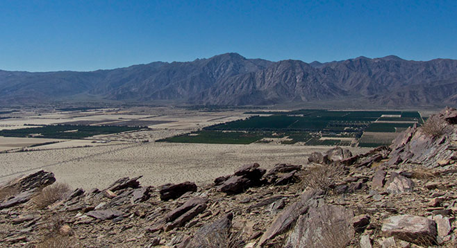
Shortly after climbing hundreds of feet above the valley, there is a raven’s-eye view of the Borrego Valley and the magnificent San Ysidro Mountains to the west of it. Continue west on the road for 1.25 miles, until you see a road coming up from the valley that crosses your trail. Go to the right on that road, continuing upslope and staying on the upper road when it branches. At 1.44 miles from Rockhouse Road there is a well-marked (with ducks) hiking trail going up the hillside. Follow it up to another former jeep road. Go left on this road. It will take you to the top of the South Shoulder, 2.59 miles from your car.The views from here are dramatic on a clear day. Looking to the east, the Santa Rosa Mountains rise as a wall on the other side of Clark Valley down below. To the southeast is the blue of the Salton Sea, while the Borrego Badlands undulate like crumpled cardboard to the south. After taking in the view, return the way you came.
This hike is not the best way to get to the peak of Coyote Mountain, but it could be extended to include a hike to the top if you have the time and an interest in getting there. There is some possibility of seeing bighorn sheep near the top. Wildflowers will depend on the rains and may or may not be part of your enjoyment. Hazards include extreme heat and rattlesnakes, but there are few cacti and no poison oak on this hike. The most comfortable time to go is from late winter to spring but the view can be enjoyed anytime it is not too hot.