Sponsored
Sponsored
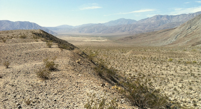
Lute Ridge is a dramatic feature in the San Jacinto Fault Zone that is easily accessible. Situated at the southeastern end of Clark Valley, it is a strike-slip pressure-ridge fault scarp that is 2 miles in length along the Clark Fault, with a high point of 1172 feet. Lute Ridge is a classic fault scarp and the largest known of its kind on the North American continent, developed in recent unconsolidated sediments.
This is a place where you can see the results of earth movement along a fault scarp. Visible is about 2100 feet of recent displacement along a right-lateral, left-stepping fault. This ridge is being moved to the northwest in respect to the rest of the alluvial fan and mountains, which are moving to the southeast. This resulting pressure ridge is continuing to be uplifted.
Begin the hike by heading north about .6 mile toward the east foot of Lute Ridge. Before ascending the ridge, hike around to the north side of the ridge to view the fault trace along the alluvial fan created from debris from the Rattlesnake Canyon area. This is where the earth has been uplifted and tipped away from the slope. On this side of the ridge, note the trail that heads northwest toward Rattlesnake Canyon and Villager/Rabbit peaks. After exploring the fault trace, backtrack to the ridge and begin climbing up the ridge. It is about .7 mile to the top of the ridge. Continue for another .1 mile and look for a cairn that marks a survey point called “Lute” on this ridge.
From the top of the ridge there is a clear view up Clark Valley, which is situated on the Clark Valley Fault. This fault extends on into Rockhouse Canyon to the northwest and to Arroyo Salado to the southeast. There is also a clear view of the approach leading to Villager Peak.
From here, retrace your route to return to your vehicle or work your way down from the ridge heading southwest to meet the old dirt Truckhaven Trail route and follow this road to the east, back to the parked vehicles.
Plants encountered on this hike are typical of the area and include creosote, cholla, and brittlebush. Along the trace of the fault scarp there is milkweed, acacia, desert lavender, desert trumpet, barrel cacti, and krameria.