Sponsored
Sponsored
An early-morning start is recommended because of the limited amount of day-use parking near the falls. Follow the signs to the Green Valley Falls Trail, taking time to explore the cascading falls from the top by traveling down the trail while making forays to the ponds with some boulder scrambling for the best pictures. The Sweetwater River water flows over granitic boulders with the longest drop at 15 feet. The pools are at different depths and sizes with rock slabs and boulders creating people magnets for a snack or sunning spots after wading in the cold water.
Toward the base of the falls, follow the Green Valley Falls Trail signpost direction to the Falls Fire Road in 0.1 mile. Turn left at the Falls Fire Road, stopping for a view at the Tom Crandall Memorial Bird Station bench and panel. This is one of the four Birds of Cuyamaca Rancho State identification stations in the park in honor of a volunteer interpreter. Look for northern flickers, Anna’s hummingbirds, Steller’s jays, and western flycatchers among the hawks and other birds found in the riparian, chaparral, and meadow habitats.
Continue south on the Falls Fire Road for a total of approximately 0.8 mile, passing the right (or west) branch of the South Boundary Fire Road. The road seems to still be the Falls Fire Road due to the “T” intersection, but at this point it becomes the “left turn” of the South Boundary Fire Road for a short distance, where the trail crosses to the east side of Sweetwater River. Check on both sides of the road for branches or stones to keep dry; wading may be required, depending on the water depth. There is then an abrupt turn to the right, onto the Sweetwater Trail, to continue in a southern direction on the east side of the river. Watch for hawks over the river gorge and chaparral plants that include Keckiella ternata, mountain mahogany, sugar bush, and Indian pinks. The trail will descend to a meadow, where you keep to the right until a Falls Fire Road appears on the left to return you the falls parking lot.
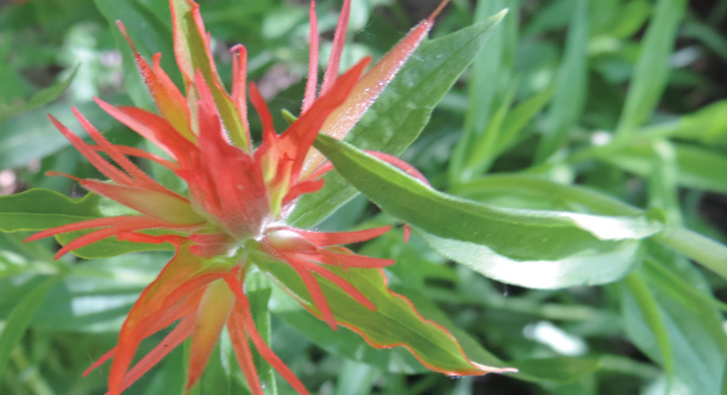
Take note of the signs found in the meadow that will help guide you on this loop. The trail passes a Sweetwater Trail sign. Continue to the right as you pass a Merrigan Fire Road post. Again continuing to the right, there will be a Saddleback Trail sign that will lead back to the Falls Fire Road. There will also be signs marking the State Wilderness Boundary and other signs indicating that no bicycles are allowed. The trail along the west side of the creek is a good place to stop for a snack or to observe Indian paintbrush, if in bloom.
Continue on the Saddleback Trail through meadow, note a large fallen oak. The trail, lined with juncus grass, leads to another “T” crossing; take a right turn toward Green Valley Falls on a section of the California Riding and Hiking Trail/Dead Horse Trail. Turn right after approximately 0.5 mile onto the South Boundary Fire Road, then turn left on the Falls Fire Road to complete the loop.