Sponsored
Sponsored
One of the more interesting hikes in the Santa Rosa Mountain area of Anza-Borrego Desert State Park is a hike up Rockhouse Canyon to Jackass Flat where Mountain Cahuilla Indians continued to live in a village area named Ataki until the late 1800s. Many deep mortero holes and slicks are scattered in the area as well as pottery shards that may be seen on the ground. Do not collect or move the shards as exact location of pottery shards is important to archeologists who study Indian sites, and they are protected by the American Antiquities Act of 1906.
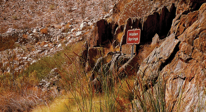
The first part of the hike follows the rough, rocky four-wheel drive road 3.1 miles up Rockhouse Canyon. At the road’s end, a foot trail begins up the narrowing canyon, which is part of the Santa Rosa Wilderness. Less than a mile up this foot trail is Hidden Spring, which is signed and may have some water that is not potable. Bees may be encountered around this spring. Look for a trail just short of the sign that leads up the ridge to Jackass Flat. At the top of the trail, El Toro Peak, the highpoint of the Santa Rosa Mountains at 8716 feet, will be visible to the north. This eastern edge of Jackass Flat was the site of the village. The trail forks at this point. Head left or west toward the head of Butler Canyon, which is the return route via a magnificent, narrow, high-walled serpentine gorge through Butler Canyon.
Plants growing in Jackass Flat include desert broom, cheese bush, creosote, Mormon tea, cactus, agave, and ocotillo. Butler Canyon has palo verde trees. A long-abandoned two-wheel cart may still be seen in the canyon, causing some conjecture as to how it ever was transported to this very remote location. As Butler Canyon begins to narrow and twist, the granite and schist walls become smooth and polished from the force of water that has swept down this canyon during occasional floods. The mouth of the canyon opens up on a boulder field that needs to be carefully negotiated down to the end of the Butler Canyon Road. It is a mile down this road to the junction with Rockhouse Canyon to finish the loop.
This mountainous area was formed by the action of faults within the San Jacinto Fault System. The Clark Lake Fault in Rockhouse Canyon is separated from the Coyote Canyon Fault by a spur of the Santa Rosa Mountains that has slipped down forming Coyote Mountain. Rockhouse Canyon takes its name from the remains of rock houses found in Rockhouse Valley where the canyon opens up. Butler Canyon takes its name from an old prospector who did mining in the area. Jackass Flat, presumably named for a feral donkey that was found in the area, is a bench separating Rockhouse Canyon from Butler Canyon.
Distance from downtown San Diego: About 108 miles. Allow 3 hours driving time. Drive to Christmas Circle in Borrego Springs via I-8, SR-79 to Julian, SR-78, and SR-3; or via Ramona, SR-78, SR-79, San Felipe Road, and SR-22. From Christmas Circle drive 7.2 miles east on SR-22 to the signed turnoff for Rockhouse Canyon Road just past post mile marker 26. High clearance or four-wheel drive vehicle recommended on this dirt road. Drive 1.6 miles and turn left (west) at the Rockhouse Canyon sign, continuing on for another 7.7 miles, crossing Clark Dry Lake and skirting around the northeast wedge of Coyote Mountain to the junction of Butler Canyon and Rockhouse Canyon and park. (Do not attempt to cross Clark Dry Lake if it is wet or muddy — you will get stuck.) No facilities.
Hiking length: 10-mile loop. Allow 6-8 hours.
Difficulty: moderately strenuous. Elevation gain/loss, 1000 feet. Carry at least one gallon of water, snacks, and wear hiking shoes or boots.