Sponsored
Sponsored
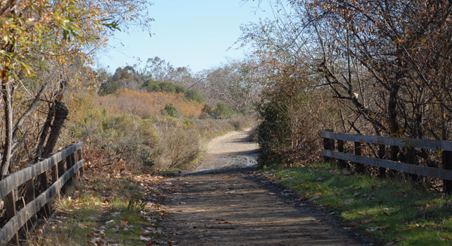
Rose Canyon is one of the many local canyons set aside for walking, jogging, and bike riding. Views of the canyon from the bridge show its diversity, with four different habitats easily distinguished: chaparral, coastal sage scrub, riparian, and oak woodlands. The canyon was named for Louis Rose, who purchased over 600 acres to ranch and run a tannery in 1853. Until his death in 1888, Rose advanced the interests of the county through his active participation in city government as a trustee, postmaster, and land speculator who developed Roseville in Point Loma. In 1913, George Sawday’s cattle operation included Rose Canyon, with the last of the ranch structures evident until the 1960s.
In winter months, frost covers the south side where shaded areas are slow to warm and cold air pools at the canyon’s base. Rose Creek, visible in small glimpses from the wide trail, centers the riparian plants that include willows, toyon, and sycamore trees that provide sporadic shade. The 23,427-acre Rose Canyon Watershed starts from runoff on the western slopes of Scripps Ranch through MCAS Miramar, joining with San Clemente and Stevenson Canyons and their tributaries while Rose Creek enters Mission Bay at the Kendall Frost Marsh.
Nature trails put in by the La Jolla Rotary Club start near the bridge and are an interesting side trip through an elfin forest. California sagebrush, currants, and toyon are among the native plants included.
Heteromeles arbutifolia commonly called toyon or Christmas berry, is a member of the rose family that includes apples, cherries, peaches, almonds and strawberries. Toyon, a tall evergreen scrub, is easily noticed during the winter months when the pulp carbohydrate levels increase, turning berries from green to a vivid red. The ripened fruit with the toxic cyanogenic glucosides shifted from the pulp into the seed are now an attractive meal to robins, mockingbirds, and cedar waxwings that assist in seed dispersal when feasting.
A good turnaround point is after crossing a bridge at 1.5 miles, when the trail veers along railroad tracks, Interstate 5, and the Rose Canyon Fault. Evidence of the Scripps Formation and Bay Point Formation margin can be viewed after a 15-minute drive south to West Tecolote Canyon.
Distance from downtown San Diego: 13 miles. Allow 20 minutes’ driving time (University City). From Hwy. 52 or Clairemont Mesa Blvd. take Genesee Ave. north to Decoro St. Park on Decoro St. on the west side of Genesee Avenue. Walk south on Genesee back to the trailhead. No facilities.
Hiking length: Three miles total, returning on the same route.
Difficulty: Easy. Elevation change up to 200 feet.
Canyoneers are San Diego Natural History Museum volunteers trained to lead interpretive nature walks that teach appreciation for the great outdoors. Schedule of free public hikes.