Sponsored
Sponsored
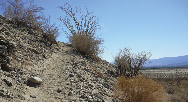
The steep winding, twisting trail climbs a rocky ridge 0.8 mile up to the northwestern saddle of Coyote Mountain that connects the entrance of Coyote Canyon with Clark Valley in Anza-Borrego Desert State Park. Just before reaching the crest of this saddle is a register with a log book that records the comments of the many visitors who have hiked up to this saddle. Although the hike returns from here back down to the trailhead, the trail does continue down into Clark Valley and Rockhouse Canyon. Indian artifacts found along the trail indicate that the Cahuilla Indians originally used this route as a short cut between Coyote Canyon and settlements in Clark Valley. In later years the route was also used by early residents of the area is save almost 6 miles from going around Coyote Mountain to get to Clark Valley. It may have been named Alcoholic Pass because of the winding trail, although one source indicates the name of the pass is a reference to the drinking habits of these early settlers and cattlemen of the Clark Valley area that liked “to wet their whistles” in Borrego Springs.
The trailhead is signed and the hike begins at an elevation of 900 feet. Head north, northwest to the ridge directly ahead only a 0.15-mile. The trail winds up the Coyote Mountain ridge. The trail is rough and rocky with loose gravel. Surrounding vegetation includes creosote, ocotillos, cheesebush, staghorn cholla, teddy bear cholla, and indigo. As the elevation increases, there is a wide view of both upper Coyote Canyon and Borrego Valley. The relatively straight line of Coyote Canyon follows the northwest-tending San Jacinto Fault Zone—one of the most active fault systems in California. Across the canyon the massive San Ysidro Mountains block the full view of Borrego Valley.
Just below the saddle at elevation 1,565 feet is the site log with a pen in a plastic bag within an old ammo can. Take some time to read the many visitor comments. Krameria, which was not seen at the lower elevation, is found here at this higher elevation. It is only a short distance up another 10 feet to the top of the saddle. The Coyote Mountain ridge separates the parallel Clark Mountain Fault, which is also part of the San Jacinto Fault Zone. The high mountain range to the east on the other side of the valley is the Santa Rosas with its 8,716 highpoint of Toro Peak clearly visible.
If you have time, after returning to the trailhead, follow the Coyote Canyon dirt road up another 0.6 miles to the Desert Gardens area of the canyon. There are picnic tables and a very short trail to another viewpoint with a bench. A sign placed here in 1971 indicates that the area was once a private inholding within the park. The Anza-Borrego Committee of the Desert Protective Council, the predecessor of the Anza-Borrego Foundation, raised funds to purchase this private land and transferred ownership to the state park.
Canyoneers are San Diego Natural History Museum volunteers trained to lead interpretive nature walks that teach appreciation for the great outdoors. For a schedule of free public hikes, refer to the San Diego Natural History Museum website.
Distance from downtown San Diego: About 100 miles (Anza-Borrego Desert State Park). Allow 2.5 hours driving time. Drive to Christmas Circle, the intersection of SR-22, SR-3, and Borrego Springs Road in Borrego Springs via Julian or Ramona. From Christmas Circle drive east 0.5 mile on SR-22 to DiGiorgio Road and turn north on DiGiorgio. Drive 4.7 miles to end of pavement and begin driving the Coyote Canyon dirt road. The Alcoholic Pass trailhead is 2.4 miles from pavement. Total mileage from Christmas Circle to the trailhead is 7.6 miles. The road may have areas of soft sand. Park in one of the roadside turnouts. No facilities. Bathrooms and water at Christmas Circle.
Hiking length: 1.7 miles out and back. Difficulty: Moderately strenuous because of the steep, rocky trail climb. Elevation gain/loss 675 feet. Trekking poles recommended. Carry water.