Sponsored
Sponsored
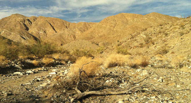
Palo Verde Canyon is aptly named for the many green-stemmed palo verde trees found in this desert canyon that leads down from the Santa Rosa Mountains. A hike up this canyon leads to an old abandoned mine long thought to have been a molybdenum prospect. The return hike has a small loop that follows a portion of an ancient Indian trail between Palo Verde Canyon and Smoke Tree Canyon to the east. Although the most opportune time to hike this canyon is late spring when bright yellow blooms festively decorate the palo verde trees, it is always a delight in any desert season because of the variety in both the plants and geologic features found in this canyon.
The hike begins at Hwy S-22, across from the entrance to Palo Verde Wash. Follow the gradually ascending canyon, being careful of the rocky, braided outwash that is strong evidence of what the force of water can move and churn as it spills from a canyon mouth. Head north, not straying off course into a smaller canyon to the east of Palo Verde.
After beginning the hike, note the many lime-green palo verde trees that line the wash and continue up into the canyon. Palo verde is Spanish for “green stick,” referring to the bark of this tree. Palo verdes have the ability to photosynthesize in the bark as well as in the leaves. This is an unusual feature also seen in the wand-like ocotillo found in this canyon. Ocotillo bark is also green, and like the palo verde, a leafless plant can generate food under dry conditions, thereby saving moisture normally lost in other plants through their leaves. This is one type of adaptation that desert plants employ to save water. The ocotillo also blooms in April, providing even more canyon color with its flame-tipped tubular flowers.
The canyon narrows at about 1.5 miles. Begin looking for a steep rocky trail up the granitic canyon wall on the right (east) side of the canyon, where a large palo verde tree is found in a small alcove. This is where the return trail will rejoin the canyon. This ancient Cahuilla trail ascends the ridge separating Palo Verde from Smoke Tree Canyon. It is part of a Native American trail leading to Wonderstone Wash, where rocks were quarried. If taking this trail to Smoke Tree Canyon, the Moly Mine is visible to the north from the trail.
Plants found in the lower part of the canyon wash include creosote, palo verde, ocotillo, krameria, teddybear cholla, and barrel cacti. Smoke trees and lavender become visible at higher elevations. Follow the canyon around to the northeast, where it opens into a bowl at 2.0 miles. Look for a trail up the ridge on the east side of this bowl that will lead to the entrance of the Moly Mine at 2.28 miles into the hike. If you have a flashlight, you can carefully peak into the mine entrance, being careful to watch out for cholla balls that will easily attach to your hiking boots. The mine entrance faces toward the west. Carefully work your way down from the mine entrance and up the ridge to the other side where the Indian trail crosses. Follow the Indian trail down 0.3 mile to rejoin the canyon floor and to begin the trek back to the trailhead on S-22.
Directions from downtown San Diego: About 100 miles (Anza-Borrego Desert State Park). Allow 2.5 hours of driving time. From Julian, drive east on Hwy 78 to S-3. Turn left (north) and follow S-3 to Christmas Circle and S-22. Turn right (east) on S-22 and drive 14 miles to Mile Marker 33 and the turnoff for Palo Verde Wash and park. From Ramona, drive east on Hwy 78 to Hwy 79. Turn left (north) on Hwy 79 and drive to S-2. Turn southeast on S-2 to S-22. Turn left (east) on S-22 and drive to Borrego Springs and Christmas Circle. Follow directions above to Palo Verde Wash.
Hiking length: 4.5 miles round trip. Allow 3 hours.
Difficulty: Intermediate. Elevation gain 650 feet. No facilities.
Canyoneers are San Diego Natural History Museum volunteers trained to lead interpretive nature walks that teach appreciation for the great outdoors. For a schedule of free public hikes:
http://www.sdnhm.org/education/naturalists-of-all-ages/canyoneer-hikes/