Sponsored
Sponsored
The recent opening of Highway 39 high above Azusa, after years of repair, allows hikers and campers to once again enjoy the beautiful Crystal Lake Recreation Area. Troubles began with the destructive Curve Fire of 2002, but now the recreation area has been spruced up and is open again for business. First, let’s note that the entire area lies within the Angeles National Forest, which means that a National Forest Adventure Pass must be posted on your car whenever it is parked.
This week’s “Roam-O-Rama” focuses not on Crystal Lake, but rather on a side trip on the way up there: the hike to Lewis Falls, a.k.a. Soldier Creek Falls. The current year’s abundant as well as relatively late rain and snowfall should ensure a generous flow of water over the falls through most of the summer. The hike to the base of the falls is short (only 20 minutes or so), but rough and rocky in places.
To reach the starting point, exit Interstate 210 at Azusa Avenue (Highway 39) in Azusa. Go north on Azusa Avenue, which becomes San Gabriel Canyon Road. (As that happens, note the San Gabriel Information Station on the right — adventure passes can be obtained there.) From Azusa, continue a total of about 20 miles. Use the roadside mileage markers to identify the starting point — a small, shaded turnout on the right at mile 34.8, where Soldier Creek tumbles through a culvert under Highway 39.
From the turnout, make your way up a beaten-down but non-official trail on the east side of the creek, under a canopy of trees still recovering from the Curve Fire. Higher up, the path becomes sketchy and your route is simply up the flood-scoured bed of Soldier Creek. A final 200-yard scramble over rocks along the stream takes you to the base of the falls.
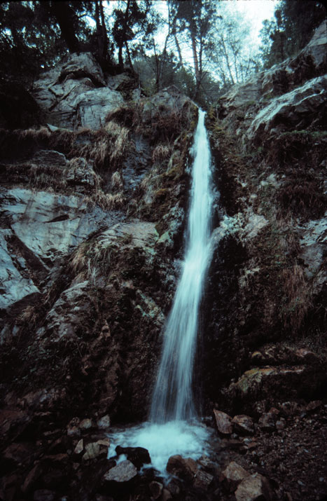
Some 50 feet above you, Soldier Creek cascades down a two-tiered rock face. The volume of water splattering on rocks and sand below is seldom dramatic; but the cool spray and the sounds of falling water are refreshing.
Above Lewis Falls, Soldier Creek tumbles over half a dozen smaller cascades. Adventurous hikers may want to try to approach this area by way of an old dirt road, intersecting Highway 39 at mile 36.8. Beyond the end of that dirt road there’s an improvise-as-you-go route down to the creek below.
This article contains information about a publicly owned recreation or wilderness area. Trails and pathways are not necessarily marked. Conditions can change rapidly. Hikers should be properly equipped and have safety and navigational skills. The Reader and Jerry Schad assume no responsibility for any adverse experience.
Lewis Falls
Discover an obscure waterfall on your way to Crystal Lake Recreation Area.
Distance from downtown San Diego: 155 miles
Hiking length: 1 mile round trip • Difficulty: Moderate