Sponsored
Sponsored
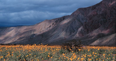
The desolate ridge of Coyote Mountain rises like the dark, furrowed flank of an elephant over the sand-drowned Borrego and Clark valleys in the north part of Anza-Borrego Desert State Park. Scattered amid slabs of granitic and metamorphic rocks of 100- to 300-million-year age, skeletal creosote-bush shrubs, soft, globular brittlebush plants, and various cacti well armored with spines cling with tough roots to tenuous pockets of granular soil. The attraction for hikers here is not so much what lies at their feet (though late-winter displays of brittlebush flowers can be eye-popping), but rather it’s the pseudo-aerial views afforded in nearly every direction. The higher you go on the mountain, the broader and better the view.
Of the many possible routes to or toward Coyote Mountain’s 3192-foot summit, here are two. For either route, be sure to wear sturdy boots and take along snacks plus plenty of water. If you go as far as the summit, the elevation gain in either case is about 2600 feet.
• East route, four miles round trip. This is a strenuous “elevator” route to the summit, with very little effort wasted on horizontal travel. First, the driving directions: From Borrego Springs follow Highway S-22 (Palm Canyon Drive, Pegleg Road, and Borrego Salton Seaway) generally east for 7.5 miles to mile 26.7, where you’ll find the turnoff for Clark’s Well Road on the left. After 1.5 miles, Clark’s Well Road branches right and you stay left on Rockhouse Truck Trail. Continue another 2.0 miles to a clearing on the left, near the base of Coyote Mountain.
On foot, go straight up the steep slope to the west. This is basically a walk-up ascent, though quite steep. You’ll need strong legs, a good wind, and a good sense of balance. Outcrops of solid, dark, desert-varnished rock provide good footing on the lower slopes. Higher up, a veneer of small stones underfoot makes climbing more difficult. While you are climbing, pause now and again to look behind you. Beyond the dry Clark Lake basin seemingly lying at your feet, the ravine-slashed Santa Rosa Mountains rise abruptly into the sky some 6000 feet. Contemplation of this scene is a stupefying exercise guaranteed to make you feel small. After reaching the summit, return by way of exactly the same route, hopefully not veering off in wrong directions that might cost you extra time and trouble.
• South route, eleven miles round trip to the summit. Park at the Pegleg Monument at Pegleg Road and Henderson Canyon Road, seven miles northeast of Borrego Springs. On foot, head northward up the remains of a now-abandoned four-wheel-drive road up along the flank of the mountain. After a couple of miles, you reach a point on the steep southwest escarpment of Coyote Mountain offering a fine view of Borrego Valley. Down below, a flat patchwork of tamarisk windbreaks, open fields, citrus orchards, palm nurseries, golf-course fairways and greens, and scattered houses stretches several miles. Near the base of the mountain, along Henderson Canyon Road, you may see lots of sightseers checking out the carpets of wildflowers that often bloom here between February and March.
If you are a casual hiker, you’ll want to turn around at the viewpoint. Strong and motivated hikers can continue another 2.5 miles up the more sketchy remnants of the same road and then hoof it cross-country over the remaining mile of ridge to the summit.
This article contains information about a publicly owned recreation or wilderness area. Trails and pathways are not necessarily marked. Conditions can change rapidly. Hikers should be properly equipped and have safety and navigational skills. The Reader and Jerry Schad assume no responsibility for any adverse experience.
Anza-Borrego’s Coyote Mountain
Pick your route up the Coyote Mountain ridge overlooking Borrego Springs.
Distance from downtown San Diego: 100 miles
Hiking length: 4.0 miles round trip (short, steep option)
Difficulty: Strenuous