Sponsored
Sponsored
The Encinitas city council has voted unanimously to deny an appeal of a seismic monitoring project at Beacon's Beach, which followed a cliff collapse in May.
As neighbors see it, the overnight landslide didn't warrant the emergency repairs the city launched in response, partnering with Scripps Institute of Oceanography to place temporary and permanent monitoring devices on the bluff.
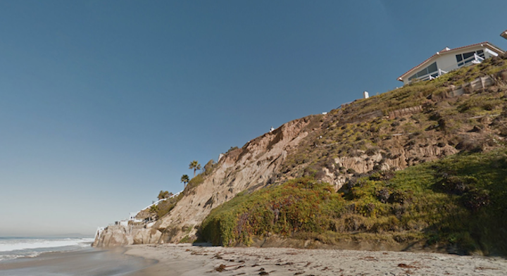
The site at 948 Neptune Avenue is known to be a risky area. According to a staff report, Beacon’s Beach was historically created by a series of massive landslides between faults that run through its access path.
In 1982 and 1983, previous stairways were damaged by slides during winter storms, and there was more bluff sloughing in April 2020. Then, on May 1, 2022, the northern portion of an old landslide reactivated, creating numerous visible cracks in the slope, and damaging the trail that goes from the parking lot down to the beach.
The very next day, the city contacted the state coastal commission to pursue an emergency permit to close the bluff and public trail immediately. The same day, fences went up and equipment went in - "unpermitted work," argues appellant Matthew Gordon, who lives on the south side of the beach.
In addition to temporary sensors and equipment for bluff stability and monitoring, temporary fencing was placed at the top of the bluff, and the parking lot was closed to block entry to the failure area.
Over a few days starting on June 20, the city repaired the existing public access trail to the beach, which they say is exempt from a coastal development permit.
The lot is zoned residential, and falls within the ecological resource open space park zone, the coastal bluff overlay and the California Coastal Commission's appeal jurisdiction.
As the $406 appeal of the county planning commission's approval of the major use and coastal development permits argues, the coastal commission didn't issue the emergency permit until June 29.
Was the work done properly? In addition to questioning the amount of unpermitted work on the bluff, the $2.5 million project – a portion of which is used for the monitoring – soil disturbance, beach closure and the installation of equipment, critics said no private property owner would be allowed to disturb a bluff without the proper permits.
According to the city, no permit was needed because repair and maintenance of existing structures are exempt from a coastal development permit.
California Department of Parks and Recreation, which owns the beach, is aware of the scope of the work being done and has given authorization for the work, city staff said.
"With an emergency permit we're given the authority to move forward" with decisions and a timeframe set by the city, said Councilmember Joy Lyndes.
Another issue was grading, which is generally prohibited on coastal bluffs. But the city said they initiated repairs of the public access trail after the slide was found stable by Geopacifica, the city's third party consultant - and the work was exempt from an emergency coastal development and city coastal development permit.
The consultant recommends that the existing public access to the parking lot be reopened to the public.
The proposed work will require shallow trenching in the parking lot, some excavations, and borehole drilling to install seismic measuring devices along the bluff and beach trail.
Adam Young, a researcher with Scripps – the project applicant – said the trenching and other work shouldn't damage the bluffs. "There's already a few bore holes in the area that didn't cause any problems." The Beacons work plan was reviewed independently by professional engineers, he added.
Del Mar is another focus site of the same monitoring project, but nothing is installed in the bluffs yet. The researchers are currently in the planning and permitting stage to install similar sensors along the Del Mar train tracks.
As for visibility of the equipment, researchers said much of it will be underground, except in the northwest corner where there will be a mast with a GPS receiver.
Permanent monitoring equipment on the bluff face will measure seismic activity at the beach, data the city can really use when it comes to providing safe pedestrian access.
"The landslide encompasses virtually all of the coastal bluff below the parking lot down to the beach, including the public parking and public access."