Sponsored
Sponsored
Port officials looking to expand local aquaculture heard some good news this month. A two-year project by federal scientists that mapped the potential for aquaculture in the U.S. found ample promise in San Diego. And zeroing in on those spots is getting easier. "We think this is the most exhaustive analysis ever done at the estuary scale in the U.S.," said James Morris, a marine ecologist with the National Oceanic and Atmospheric Administration who presented the results to the Port.
The Exclusion and Opportunities Analysis for Aquaculture in and Around San Diego Bay draws on ten years of ocean data to tap suitable sites, while ruling out others. The Port has been doing its own studies since 2015, and joined forces with the California State Lands Commission on a pilot project known as the San Diego Ocean Planning Partnership. All of the efforts have yielded a new assessment of local waters, along with an app they were to release on April 22, Earth Day.
Coastkeeper, which has kept a wary eye on local aquaculture, at least the sort dubbed "floating feedlots" for their echoes of factory farm issues (in this case, sea-lice, chemicals, and infectious diseases unleashed on wild habitats) previously commented on the draft report last Dec. "While a mapping tool may be useful" to show what extractive, protective, or other uses exist, "we urge great caution to the Port and SLC not to allow such a tool to be used in a way that facilitates industrial or other development which would further strain our coastal and ocean resources."
The commercial fishing industry sent a slew of comments on the new competition proposed in the ocean sphere. Among their worries: the Port decides on future uses, and at the same time is an economic partner in several aquaculture ventures within, or proposed for, the project area. "This conflict of interest will limit their ability to be an impartial arbiter of competing uses when one of the uses is aquaculture," wrote the San Diego Fishermen's Working Group. The same applies to the SLC, "should it be in the position of weighing non-lease uses over income-producing new lease applications."
Fishing industry groups aired concerns that the new tools might be used to implement ocean zoning — which the port says is not the case. "There are a lot of opinions about aquaculture," Morris said. The NIMBY stance is "one of the biggest challenges." Hence, the need to pinpoint suitable sites. But where should a fish farm go? Can it co-exist with commercial fisheries, with the Navy? Can it mesh with public uses and avoid environmental harm?
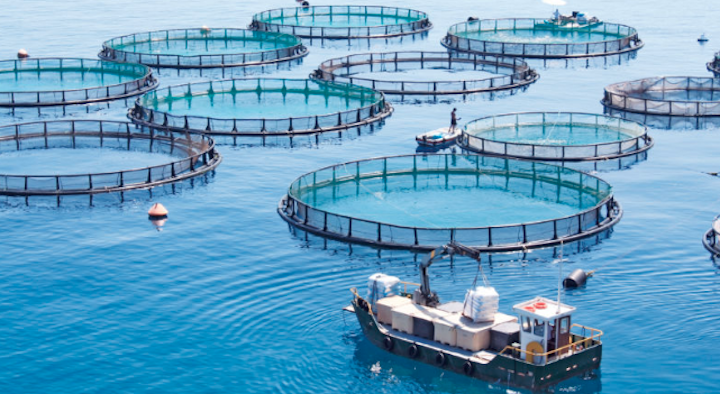
Until now, the answers were scattered in a range of official databases. "We knew we needed more," he said. "An app, that's essentially what we created. A Zillow for the nation." While San Diego already has several aquaculture projects, most are shellfish. That may change. It turns out, the controversial Rose Canyon Fisheries, which has now morphed into Pacific Oceans Aquafarms, has big plans for a farm with open ocean fish pens near Mission Beach, in federal waters less than four miles off the coast (regulation by state and local municipalities ends three miles out). "We've been working with one of your collaborators, Pacific Ocean Aquafarms, to consider a partnership in trying to develop an offshore aquaculture industry. To find the right spot for that farm," Morris said.
The ocean maps collect data on things like temperature and salinity, nutrients, vessel traffic, endangered species. They note tribal lands, federal statutes, nearby beach renourishment projects; all in a split second. Climate change isn't accounted for because it would require much "higher resolution" data.
The app can be used by anyone. NOAA worked with port staff to find "things compatible with aquaculture, and those that aren't." They mapped in and just outside the bay, a total planning area of 50,000 acres. Within the bay, they began with 11,000 acres; in the coastal ocean, 38,000 acres. An exclusion analysis left 1,800 farmable acres inside the bay, and about 7,000 acres outside the bay. Thresholds for each species, as well as the gear used to cultivate them, were developed, and a list of candidate species, such as giant kelp and red algae, was made. In the end they found "almost 40 different opportunities."
Within the busy bay, the searching is needle in a haystack level. "We're literally looking for small polygons of space," he said. "There is opportunity in San Diego bay, though, to develop an aquaculture industry." For example, shellfish, making use of the "Flupsy" nursery system, and algae. "Both provide significant ecosystem services that can help habitat and water quality." Start small, build on success, Morris advised.
"What we see across the nation, there's been a lot of money lost in aquaculture because the adequate planning rarely takes place." But there are now "thriving shellfish operations on both coasts" they can learn from. The commissioners are ready. "It looks like we have, from the map, 7,800 acres we can farm free and clear," said commissioner Merrifield. "If we were to put a million bucks or so into our experimentation and initial deployment, we're probably getting close, within six months to a year to expand."
"We used to have abalone growing naturally in the bay. They got over-farmed by scuba divers...So we know this can work. We want to scale it the right way."