Sponsored
Sponsored
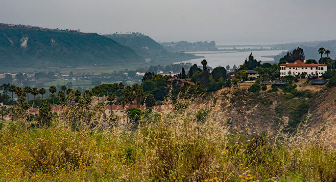
The Ridgeline Trail is a highly scenic trail through native chaparral and coastal sage scrub habitat. It has inspiring views of the Batiquitos Lagoon and the Pacific beyond as it takes you along a ridge high above the dramatic cliffs of San Marcos Creek’s Box Canyon. It is one of the most interesting of the many trails within Carlsbad’s Rancho La Costa Preserve.
Begin hiking on the gravel road leading east-northeast from the El Fuerte Street Ridgeline Trailhead. Initially the trail is on the west side of a small tributary canyon. After 0.3 mile, the trail crosses an intermittent stream then turns south and becomes a well-marked dirt trail. As you descend, views down into Box Canyon open up. In some places, the walls of the canyon are sheer cliffs. It appears to contain a vigorous riparian forest habitat. Note: Hiking into Box Canyon is prohibited and is marked with no trespassing signs. Violators face a heavy fine.
Further on, the trail crosses an intermittent stream with riparian habitat containing southern cattails, mule fat, black willows, and arroyo willows, as well as flowing water after rains. This will be your best opportunity to enjoy a close encounter with the riparian habitat.
After hiking about 0.6 mile, the trail bends toward the east and more or less follows the power lines. Don’t forget to look behind you to the west. On clear winter days you will have excellent views of Batiquitos Lagoon and the Pacific beyond, although on hazy June mornings they may be obscured by coastal fog or overcast.
One mile after leaving the trailhead, you will come upon a picnic table under a ramada — a good place for lunch or resting in semi-shade. It is also a good place to observe the habitat the trail has been traversing. The dominant shrubs are California sagebrush, black sage, coyote brush, chamise, and flattop buckwheat, all common plants of coastal sage scrub. One of the more unusual plants here is spine-shrub (Adolphia californica). It is relatively rare in other locations and considered to be endangered but is common here.
The trail now heads in a northeast direction. In another 0.36 mile it forks. Taking the loop trail to the right will lead to the top of a rounded hill, giving you more views into Box Canyon and views of the lands to the east where Denk Peak and Double Peak dominate the horizon. From here, another fork in the trail on the right leads to a dead end. Take the trail to the left, marked by a post with a red arrow. In another 0.1 mile it merges with the main trail and then continues for another 0.15 mile before turning sharply east (right).
In another half mile you will come to the Corintia Trailhead and the end of the Ridgeline Trail. You could arrange to be picked up here for a one-way 2.14 miles hike or go back the way you came for the recommended out-and-back hike. If you elect the out-and-back hike, be prepared for the last 0.35 mile of the trail, which is steep and paved with concrete.
Driving Directions: From I-5, exit at Palomar Airport Road and drive east 4 miles to El Fuerte Street. Make a right turn and continue for 2.5 miles on El Fuerte to the Ridgeline Trailhead, on your left. There is unrestricted parking along the curb near the trailhead.
Hiking length: 4.2 miles, out and back. Allow 2 hours.
Difficulty: Moderate. Elevation gain/loss of 1400 feet.
Other: Leashed dogs and bicycles are allowed. The trail is open from sunrise to sunset. The trail is best in winter for views and spring for wildflowers.