Sponsored
Sponsored
The San Elijo Ecological Reserve protects one of the largest remaining wetlands in Southern California as well as the bordering hills containing dense stands of maritime chaparral and coastal sage scrub. The Stonebridge Trail takes you through these chaparral-covered hillsides as it descends to and then crosses the marsh before ascending to the Stonebridge plateau, where you find grasslands and coastal scrub. The plateau provides lookouts to open water, with a chance to see a variety of beautiful wading birds and other domestic waterfowl. Be sure to bring your binoculars or spotting scope.
From the trailhead at the end of Santa Helena Drive, start hiking down the dirt service road going north. The chaparral on either side of the trail is dominated by large lemonadeberry, black sage, buckthorn ceanothus, California sagebrush, broom baccharis, and flattop buckwheat. There are scattered Torrey pines and oaks further up the hillsides. Closer to the wetlands, numerous arroyo and Gooding’s willows, mule-fat, and some cottonwood trees intermingle with chaparral and coastal sage species. La Orilla Creek discharges into the lagoon near here, bringing fresh water after winter rains.
Continue due north on the trail. After walking 0.4-mile, you come to the marsh crossing. From about May through the summer, the marsh crossing should be dry and uneventful. However, after rains and during winter and early spring, you could sink up to your knees in mud. Thus, it is prudent to stop here to avoid losing your boots and wait for a dry day in May before proceeding. You may find an improvised bridge across these muddy waters, but the Reserve considers the trail closed at this point until this stretch is dry.
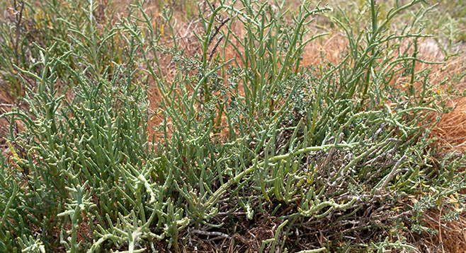
While you are waiting for the mud to dry, look at the vegetation growing here. These marsh plants include highly salt-tolerant species, especially pickleweed, alkali heath, and salt grass. They can thrive here because their physiology allows them to take up brackish water, filter out the salt, and sequester the salt in special cellular organelles where it won’t interfere with essential metabolic cellular functions.
When you can safely cross the marsh, continue up the trail, now periodically marked with signs, which will take you up onto the Stonebridge mesa. The mesa is mostly flat with swales periodically cutting down to the wetlands below. The swales are thickly vegetated with large lemonadeberry shrubs, elderberry trees, California sagebrush, black sage, and other coastal scrub species. The mesa itself is covered with filaree and non-native grasses, interspersed with widely scattered clumps of coastal cholla, prickly pear cactus, and lemonadeberry.
The trail forks about 0.5 mile from the trailhead. Keep to the left and in about 0.3-mile, you will come to a bench overlooking pools of brackish water where waterfowl can be observed. Birds that have been observed in the San Elijo Lagoon include both snowy and great egrets, double-crested cormorants, common loons, pied-billed grebes, northern shovelers, mallard ducks, and several others. The pied-billed grebe builds a floating nest anchored to marsh plants, and the young chicks ride on the parent’s back after hatching. One of the most unusual birds that may inhabit the marsh is the least bittern, a beautiful small bird. There are records of least bittern nests in the San Elijo Lagoon, but you are unlikely to spot either its nest or the bird as it moves slowly and hides in dense cattail and sedge thickets. If you do, consider yourself very lucky.
Continue on the trail as it snakes around the Stonebridge mesa, eventually crosses the heads of two adjacent swales, and then proceeds due west down a peninsula separating the wetlands from Escondido Creek. It ends 1.3 miles from the trailhead at a point on the peninsula overlooking Escondido Creek’s entrance into the wetlands of the lagoon. Although no flowing water is evident, there is a dense riparian growth following the creek bed with an abundance of sycamores and willows festooned with a luxurious growth of wild grape. The trail officially ends here. Return the way you came for a 2.6-mile hike or explore some of the many use trails that meander around the mesa.
Driving directions: (Solana Beach) From I-5 N, take exit 37, Lomas Santa Fe Dr., and continue straight across Lomas Santa Fe Dr. to Santa Helena Dr. From I-5 S, take exit 37, Lomas Santa Fe Dr., and turn left onto Lomas Sant Fe Dr., then turn left at the 1st cross street onto Santa Helena Dr. The trailhead, named “Santa Helena” on Lagoon signs, but “Stonebridge Trailhead” on Google maps, is at the dead end of Santa Helena Dr.
Hiking length: 2.6 miles, out-and-back. Allow 1.5 hours hiking time.
Difficulty: Easy. Elevation gain/loss 500 feet. Leashed dogs allowed. No bicyclists.