Sponsored
Sponsored
Start hiking up the short, steep trail through somewhat degraded coastal sage scrub habitat. If making this journey after a long rainless summer, many of the shrubs will be leafless or nearly so. They are not dead but dormant. With the onset of winter rains, the black sage, California sagebrush, and buckwheat will come back to life, joining the evergreen lemonadeberry, laurel sumac, and toyon that are the main signs of plant life in the coastal sage community during our annual long summer drought.
However, there are a few scattered coyote bushes that are not only green but also may be in full flower. Also, look closely at some of the leafless stems and you may find they have small lavender-tinted or white ligulate flowers. These are San Diego wreath-plants (Stephanomeria diegensis), a member of the sunflower (Asteraceae) family. It loses all its leaves during the summer, but the plant is still alive and flowers long after it has taken on the appearance of the completely dead black mustard. What appears to be a single Stephanomeria flower actually is a head. Each head is composed of up to 11 ligulate flowers.
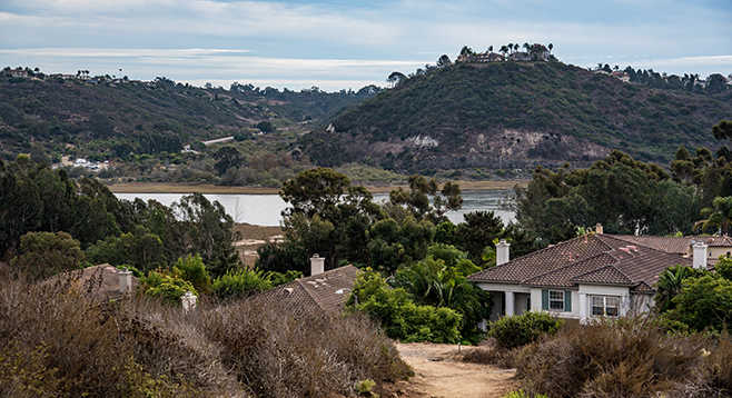
Pause to take in the views down to the Batiquitos Lagoon and west to the ocean upon reaching the top of this first hill. The views can be quite striking, particularly after a rainstorm has cleared the air.
Continuing down the hill, in 0.2 mile there is a cross street, Calidris Lane. The trail continues on the other side of the street, enters a eucalyptus forest, and then proceeds up a shallow canyon. Eucalyptus trees now dominate the upper slopes, large clumps of lemonadeberry and toyon flank the trail, while patches of star thistles, cheat grass, and Russian thistles fill much of the space between the larger shrubs.
The trail crosses Kestrel Drive 0.47 mile from the Savannah Lane Trailhead. In another tenth of a mile, it appears to split. The short trail to the left leads to a viewpoint on a hill with an excellent ocean panorama, but it’s a trail stub that does not go further. After enjoying what could be a highlight of this hike, go back to the trail junction and continue up the main trail. You have nearly another mile to go to reach the turn-around on Kestrel Drive, near Aviara Parkway.
The middle segment of the trail is somewhat less interesting than the beginning. It is close to the backyards of homes on a hillside just above and parallel to Kestrel Drive. The native vegetation has been replaced with non-natives; ice plant and myoporum as ground cover, melaleuca and acacia dominate the shrubs, while trees are mainly scotch pine and eucalyptus.
However, it is worthwhile to persist. The final segment departs from the close proximity of homes and enters another area of comparatively healthy coastal sage scrub. In addition to the usual species, look for coastal bushmallow (Malacothamnus densiflorus), Orcutt’s goldenbush (Hazardia orcuttii), and coast cholla (Cylindropuntia prolifera). There may even be a few rare plants, such as Parish nightshade (Solanum parishii), found here.
The trail makes a right turn when you reach the bottom of the hill, proceeds just below Aviara Parkway, turns right again, and ends with a short, paved climb up to Kestrel Drive. You could arrange to be picked up here for a 1.3-mile hike, but it is assumed to be an out-and-back hike, so return to the starting point.
Views from the hilltops include Batiquitos Lagoon and the ocean.
Distance from downtown San Diego: 32 miles (Carlsbad). Allow 35 minutes driving time. From I-5N take exit 45 at Poinsettia Lane and go east. In 0.10 mile, turn right on Batiquitos Drive and continue 2.3 miles to Goldenstar Lane. Turn left (north) on Goldenstar Lane, then another left (west) onto Savannah Lane. The trailhead is on the right, near the intersection of these two lanes.
Hiking length: 2.6 miles out and back.
Difficulty: Moderate. Elevation gain/loss 700 feet, with several short, steep hills.