Sponsored
Sponsored
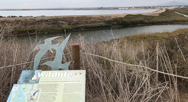
A new birding trail has been opened at the very bottom of San Diego Bay in Imperial Beach within the San Diego Bay National Wildlife Refuge. There is a well-marked dirt path stemming from the west end of the parking lot where you will find yourself surrounded by California flat-topped buckwheat. Right outside the western edge of the parking lot is a sign describing a rail line that went from the Hotel Del Coronado looping along the bay into San Diego, known as the Coronado Beltline Railroad.
The new trail extends to the west for 0.4 mile. Plant life on this walk is sparse and stressed from traffic and the weather. The real pay-off here is the birds. This is the western-most flyway in North America, called the Pacific Flyway. Migrating birds from their spring/summer breeding areas in Canada and South America use this part of San Diego Bay as a stop-over or destination. The largest number and variety of birds are seen in the winter. You can choose to make this a monthly stop and watch as the bird populations change with the seasons. There are two large viewing platforms with benches that provide an unrestricted view. You don’t have to do anything but sit and wait for the different varieties of birds to whiz by. It is especially rewarding in late winter/early spring as different varieties of terns use the bay for nesting and breeding. This past April (2018), there were an estimated 16,000 terns in one area alone. Birds that are resident here are: Snowy Egrets, Great Blue Herons, Black-Necked Stilts, Black Skimmers; and let’s not forget the terns: Fosters, Elegant, and Caspian terns that come from Canada and South America to winter here. Keep your eyes peeled and you’ll pick up an Osprey or a Northern Harrier. A state and federally protected bird that you will find here is Belding’s Savannah Sparrow, a rare subspecies of the Savannah Sparrow. If you have binoculars, be sure to bring them!
If you need a plant fix, head back three blocks to 13th Street. Again, go to the north end, where there’s plenty of parking at a new commercial area that has been very well done. Between the bike path and the building is an excellent native plant garden where you’ll find flat topped buckwheat, Mexican elderberry, bush penstemon, coast paintbrush, spike sedge, and pokeweed. Pokeweed or pokeberry (Phytolacca americana) is a non-native, naturalized, poisonous herbaceous perennial that is a grape look-alike. To a child, it looks like a cluster of purple grapes. Beware! Pokeberries have red stems instead of the woody stems of grapes. Although poisonous to humans, birds love them.
You have the option of staying on the south side of the bike trail and enjoying the native garden, or crossing the bike trail (use caution and watch for on-coming bikes) to find another bayside viewing area with benches. This will give you an excellent view of the bay looking towards Coronado and the South Bay Salt Works, which has been in continuous operation since 1860! Both of these walks and bird- watching sites make for a nice, easy morning outing.
The San Diego Bay National Wildlife Refuge has a second distinct area from the walk described above in South San Diego Bay. This second area is the Sweetwater Marsh in Chula Vista where the Living Coast Discovery Center is located (Reader Roam-O-Rama 8-7-2013) and where regular bird walks are held. The walks are free and a good way to learn about the birds that frequent this part of the Pacific Flyway. For more information about these walks, check this website: https://www.fws.gov/refuge/San_Diego_Bay/visit/visitor_activities.html
BAYSIDE WALKING AND BIRDING TRAIL (Imperial Beach)
Do this walk seasonally to view different bird populations.
Driving directions: From I-5, take exit 5A toward Palm Avenue/CA-75. Go west onto Palm Avenue for 1.4 miles, then turn right onto 11th Street. In 0.3 mile, turn slightly left onto Cherry Avenue and onto 10th Street. Park in the lot next to the Imperial Beach Public Works Department. Hiking length: 0.8 mile out-and-back. Allow one-half to one hour hiking time. Difficulty: Easy with little evaluations gain/loss. Use caution crossing the bike path as this is heavily used on weekends.