Sponsored
Sponsored
Tucked away in a quiet neighborhood of Ramona is a seldom-visited picturesque spot known as Luelf Pond. The pond and County Preserve were most likely named after Oscar Luelf, who was a member of the County’s Farm Bureau in the mid-20th century.
Regardless of the origin of the name — or its pronunciation, usually “Loolf” — this is truly one of the area’s hidden gems, which is especially amazing because over 90% of the preserve was burned in the 2003 Cedar Creek Fire, which covered more than 270,000 acres and remains one of the State’s largest and most devastating wildfires. The intervening 15 years have allowed much of the vegetation here to recover, and you may have to look closely to find clear evidence of the 2003 fire.
After parking on the street, find the trailhead at the south end of the cul-de-sac. Since you are in the midst of a residential neighborhood, please be considerate and do not disturb those living nearby. This first section of the trail is short, less than a quarter mile, and is mostly under the shade of stately coast live oaks. This makes for a pleasant walk on all but the warmest of days. Oaks are fire-adapted, and while immediately after the fire many of these trees looked to be dead or badly damaged (with blackened bark and brown dead leaves), within a year they were already showing signs of new growth.
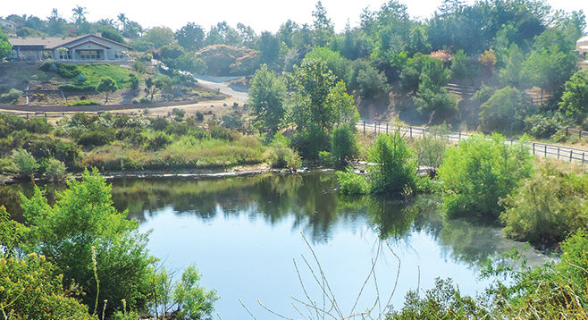
Emerging from under the oaks, you will find yourself back on a paved road (Duck Pond Lane). Turn left and you will quickly be rewarded with the sight of Luelf Pond. After a rainy season the pond will be filled to overflowing. Waterfowl, insects, frogs, and a variety of water-loving plants find refuge here. After enjoying the pond, cross the road and re-enter the preserve. This location can also serve as a parking spot from which to begin your hike if you wish to skip the first section of the trail. Here you’ll be walking beside a small seasonal creek. If there is water or damp soil, be on the lookout for some interesting and showy plants such as the yellow-flowered seep monkey flower with the tiny red spots in its throat, or the spectacular scarlet monkey flower, which lives up to its name. Continue on for about half a mile until you come to a metal gate that has clear signage to proceed no further.
You may use this as your turn-around point, or if you are in the mood for some uphill climbing and longer views, go back about 200 feet and turn uphill. The trail here is steep with no switchbacks and is often overgrown and rutted. The plant community surrounding the trail is chaparral dominated by chamise. This may be the most widespread chaparral community in southern California, and chamise itself is the most common California native plant species found west of the Sierra Nevada Mountain range. The tiny needle-like leaves help to conserve water but can also make chamise extremely flammable in wildfire conditions. After 0.75 mile, you will come to the end of the preserve and another locked gate. This will be your turn-around point, but first enjoy the views of Ramona and the Santa Maria Valley.
Driving directions: (Ramona) Take CA-67 towards Ramona and turn right onto Dye Road. Go 1.0 mile. Turn right on Southern Oak Road and go 0.7 mile. Turn right on Oak Shade Lane and go 0.2 mile. Park at the end of the street.
Hiking length: Under 3 miles out and back. Allow 2 hours.
Difficulty: Moderate out-and-back route. Elevation gain/loss: 400 feet. Hikers, leashed dogs, and horses allowed.