Sponsored
Sponsored
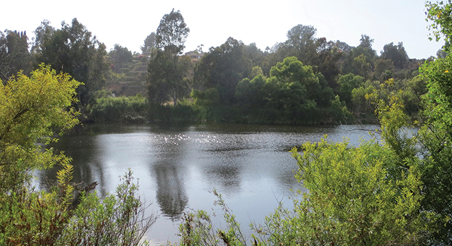
Once the site of a sand and gravel quarry, Morrison Pond is now a partially-secluded spot within the Sweetwater Regional Summit Park that is great for nature watching. It is an open preserve with multiple trails that run along the Sweetwater River. Although Sweetwater Road can be seen from Morrison Pond, the traffic noises recede in the quiet of this place. The trail is a short loop that can be extended by taking one of the many connecting trails. This hike offers a great opportunity to sit and enjoy nature, especially birdwatching.
While the trail has more of a coastal sage scrub environment, Morrison Pond has lush vegetation and a riparian environment. One can see amphibians, cottontails, and birds such as yellow warblers, black-headed grosbeaks, least Bell’s vireos, and Nuttall’s woodpeckers. The most prolific pond waterfowl here are coots, herons, and egrets. There are 64 species of heron, but the main herons seen at the pond are the great blue heron and the great egret. The great blue are medium-large, tall, wading water birds with long necks, long dagger-like beaks, and long skinny legs similar to storks and cranes. Great egrets are biologically the same as other herons but are slightly smaller and are white or a pale yellow-brown color. Coots are small water birds, commonly mistaken for ducks, with predominately black feathers on their bodies, a colorful beak, red to dark-red eyes, and a decorated forehead. Besides their outward appearance, coots differ from ducks in that they do not have webbed feet. Their toes fold back to help them walk on dry land, and they have lobed scales on their lower legs.
Fish have also been spotted in the pond, and fishing is allowed. It is alleged that blue gill, catfish, and bass can be had, but the story is that most fishing folks have not been able to catch anything as of late. Still, you are welcome to bring your pole and try your luck.
A kiosk with a map of the park marks the trailhead, and a rock-lined path designates the beginning of the trail. Follow this path until you reach a junction with a willow tree and bench on your left. As this is a loop hike, you can go in either direction; but for today turn to your right. The trail itself is very sandy and has minimal elevation change, with multiple benches and informative displays strategically placed around the pond. About halfway around the loop, you will approach another junction. This section of the trail is still sandy and lined by a three-railed wood fence on one side. Go left to stay on the Morrison Pond loop.
About three-quarters around the loop, you come to a junction marked by a trash can. Once again, stay left to finish the Morrison Pond loop. You will cross a dry riverbed with rocks. Follow the loop to return to your starting point. Although the last part of the trail is well-shaded by large willow and pepper trees, the majority of the loop is exposed to the sun, so make sure to wear sunscreen and bring water.
Driving directions: (Bonita) Take I-5 south to CA-54 east and go 4.4 miles. Take Exit 5 for Briarwood Road and turn right. In 0.6 mile, turn left onto Sweetwater Road. The park entrance will be on your right about 200 feet after making the turn onto Sweetwater Road, designated by a Sweetwater Regional Summit Park sign. No facilities.
Hiking length: 0.85 mile round-trip. Not wheelchair accessible. Leashed dogs, mountain bikes, and horses allowed on the trails.
Difficulty: Easy with little elevation gain/loss. Good for beginners.