Sponsored
Sponsored
The Tijuana River Estuary is unique in California as the only estuary that does not have a road, railway crossing, or bridge across the river mouth. The salt-marsh estuary has remained connected to the sea. To reach the other side, you must go around the entire Tijuana Slough National Wildlife Refuge, over seven miles around. Depending on what you would like to see, there are four main areas to visit. A great place to start is the visitors’ center, at 301 Caspian Way in Imperial Beach.
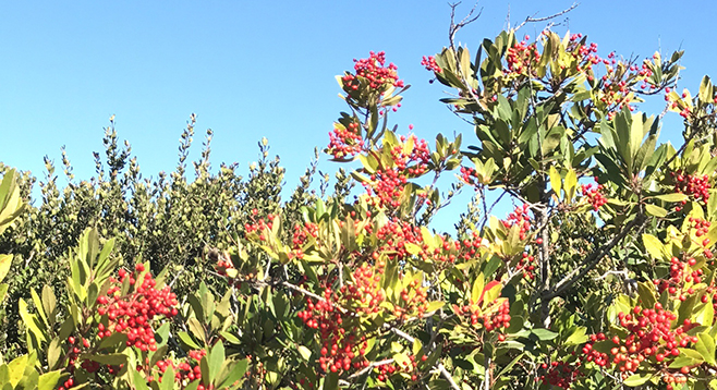
You will find local vegetation along the pathway down to the visitors’ center. The plants with the rust-colored flowers near the parking lot are wild buckwheat (Eriogonum fasciculatum). Along the path to the visitors’ center broom baccharis (Baccharis sarothroides) grows. Broom baccharis is one of the species that has male and female plants that are identified by their flowers. The Canyoneers have a saying: “white bride, yellow fellow” because the male plants bloom in yellow flowers while female plants have white flowers. Around the time the baccharis is in bloom, the toyon (Heteromeles arbutifolia) bush is full of red berries.
The edge of the sidewalk leading from the parking lot to the visitors’ center is the beginning of a map indicating the U.S.-Mexico border. As you follow the border line toward the visitors’ center walking west, the path enters a map of the Tijuana River watershed. The binational watershed is 1/3 in San Diego County and 2/3 in Tecate and Tijuana municipalities. The visitors’ center is open Wednesday–Sunday and is a great place to discover which birds have been recently sighted or to check displays and field guides to identify local species.
Continue out the back door (or walk around the visitors’ center building if closed). From the patio, the hills of Tijuana, the beach of Playas de Tijuana, plus the Coronado Islands (just south of San Diego Bay) are visible. There are multiple routes, but the paved path due west goes toward the ocean, bird-viewing sites, and the weather station. The pavement ends just past the patio and the trail continues across a little wooden footbridge; turn left (southeast) at the intersection to continue. Here you can listen for birds or look for them in the water or across the salt marsh. There is a bench and a footbridge along this route. Continue along the water’s edge, until the path turns right to head south.
Up ahead the trail splits. Trails to the north return to the visitors’ center and parking lot. The other option is to go straight east where the path loops around to Grove Avenue (Imperial Beach) and the River Mouth Trail. Keep this in mind if continuing to explore the estuary on foot.
Anticipate incredible viewing areas by heading right, continuing south down the North McCoy trail. The trail will pass goldenbush (Ericameria sp.), lemonadeberry (Rhus integrifolia), California sagebrush (Artemisia californica), coast cholla (Cylindropuntia prolifera) and other native species. Near one of the most significant bridges on the trail, you will find laurel sumac (Malosma laurina). In the water, you will likely see snowy egrets (Egretta thula), great egrets (Ardea alba), great blue herons (Ardea herodias), or black-crowned night herons (Nycticorax nycticorax).
Beyond the bridge, the short (less than 0.3 mile) North McCoy trail continues past salt-marsh plant species such as pickleweed (Salicornia virginica), cactus species, and several amazing viewing areas, to look for resident or migratory birds, depending on the time of year. The Tijuana Estuary is home to 398 bird species, including the California least tern, the clapper rail, and least Bell’s vireo, and 21 other sensitive and endangered species.
The North McCoy trail ends at a viewing area, a good time to look for birds that are there. You may notice there is a viewing area across the tidal estuary channel. That viewing area is at the end of the South McCoy trail. If you would like to get there on this trip or see the river’s mouth, head back, walking north along the McCoy trail to the junction just past the footbridge and turn right, heading east toward the houses. Either you can remain in the reserve on a side trail at the back of the houses, temporarily leave the reserve at Grove Avenue and walk through a neighborhood in Imperial Beach as you head south and re-enter the reserve at Iris Avenue, or drive from the visitors’ center to the Iris Avenue trailhead.
Re-enter the reserve, heading south from Iris Avenue, and walk along the one-mile River Mouth Trail, turn right, and head west. There will be a junction ahead. The viewpoint is to the left and overlooks the Tijuana River’s mouth. From here, walk north along the South McCoy trail, an additional 1.5 miles round trip, or retrace your steps back to your parked vehicle.
There is more to see in the Tijuana River Valley. The 1.5-mile-long (round trip) North Beach Trail leads straight along the dunes and coast to the estuary mouth (trailhead at the end of Seacoast Drive, just south of Imperial Beach pier and businesses). In the south, Border Field State Park (accessible along Monument Road, open to vehicles Friday–Sunday) offers views of the official U.S.-Mexico Border Monument. South Beach Trail (3.0 miles round trip) mirrors the North Beach Trail, providing a third viewpoint of the river mouth. In addition, there are miles of horse and hiking trails throughout the river valley, with trailheads on the eastern edge of the reserve.
Distance from downtown San Diego: Approximately 19 miles (Imperial Beach). Allow 30 minutes driving time. From I-5 South, take exit 4, Coronado Avenue, then continue west as it becomes Imperial Beach Boulevard. Turn left (south) on 3rd Street and continue as the road turns left (east) and becomes Caspian Way. Turn right (south) at the Tijuana Estuary sign and park in the Visitors Center parking lot. Hiking length: Variable. 0.6 mile along North McCoy trail only or approximately 4 miles round trip following the River Mouth Trail to the South McCoy Trail.
Difficulty: Easy, with less than 50 feet elevation change.
Facilities at the visitors’ center. Binoculars recommended.