Sponsored
Sponsored
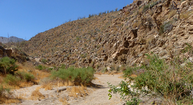
Hornblende Canyon twists and turns as it climbs the shoulder of Granite Mountain. It has a great variety of plants, some dry waterfalls, old mines, plus Native American sites with morteros. As part of the Granite Mountain complex, the dominant rock here is hornblende-biotite tonalite, a granitic, which is an intrusive igneous rock consisting of feldspar, quartz, mica and/or amphibole minerals (like hornblende). Hornblende is a dark rock-forming mineral. Biotite is black mica. Another rock found here is the gray-brown Julian schist, a metamorphic with twisted, streaked bands of darker and lighter material that originated as seafloor sediment millions of years ago and underwent great pressure and heat to recrystallize into its present form, which is a biotite mica schist. This area sits in the Elsinore fault zone and is subjected to major tectonic forces.
The canyon walls quickly rise from the trailhead. About a mile up the canyon is the first dry waterfall that needs to be scaled. Soon after passing the waterfall, begin looking for tailings from an old mine on the left. This mine and others in the area are probably digs from prospectors looking for gold or tourmaline in areas of Julian schist and pegmatite dikes. Do not enter the mines, as they could be dangerous or you could disturb bats that might reside in them.
Just over two miles from the trailhead is a second dry waterfall. Carefully climb up the waterfall to view the many morteros found at the top that indicate use of this area by the ancient Kumeyaay. Although this is the recommended turnaround point, the canyon can be explored for another two miles to its end, which would require scaling more dry waterfalls.
What makes this canyon so special, besides the varied colored minerals, granitics, and Julian schist, is the variety of plants including desert apricot, jojoba, California juniper, Mormon tea, Parish’s viguiera, Gander’s and pink teddy-bear cholla (Cylindropuntia fosbergii), brittlebush, creosote, milkweed, agave, barrel cactus, and ocotillo. The barrel cacti are especially large. In spring, this canyon rivals Plum Canyon for a display of wildflowers, and because of its higher elevation, it can be hiked late into the desert season. June is not too late, especially if hiked early morning or late afternoon.
On a late seasonal hike one can see the green curling seed pods on catclaw acacia, fruit on the desert apricot, berries on the juniper trees, and desert willow in bloom at the parking turnout across from the trailhead. Milkweed seedpods will be open, and if you look carefully, there may be small orange and black milkweed bugs clustered on the seedpods.
Distance from downtown San Diego: 81.3 miles (Blair Valley/Box Canyon). Allow 2 hours driving time. From SR-163N, take I-8E to SR-79N/Japatul Valley Road. Turn north toward Descanso and continue just under 3 miles; turn left to remain on SR-79N until it ends just past the post office in Julian. Turn right on SR-78, go approximately 11 miles down Banner Grade to Scissors Crossing, then take a right onto SR-2; after 9.1 miles there is a small pull-out on the south side of the road for parking, 0.4 mile past the Box Canyon Monument. Carefully cross the road to begin the hike.
Hiking length: 4.4 miles.
Difficulty: Moderate with elevation gain/loss of 900 ft. Dogs not allowed. No facilities.