Sponsored
Sponsored
Maple Canyon lovers heard the echo of the freeway building in the early 1960s at the start of summer, when they found about 50 feet of the west entry to the canyon had been paved over with asphalt.
The paving came as a surprise to the Friends of Maple Canyon who are working to protect and enhance the half-mile trail through the canyon floor. The canyon starts at Maple Street, west of State Street, and arcs northeast to Third Avenue between Quince and Redwood, traveling low under the First Avenue and Quince Street bridges.
“The city crew said they thought it would be a place for volunteers to stand,” Friends of Maple Canyon president Roy McMakin said. “It had been paved long ago. Somebody altered what they planned to do and made it bigger — they ran asphalt up the hill there.”
Indeed, the asphalt climbs the side of a hill toward one of the houses.
“It wasn’t the Storm Water Department,” says Tershia D’Elgin, a writer and environmentalist. “It was the open space or parks department. Some previous deputy director must have thought it would be a good idea and he’s gone. It was on some kind of list and they finally got to it.”
City spokesman Tim Graham confirmed that they did the asphalt work.
“Park and Recreation crews requested the work in order to restore an existing asphalted area at the site. Over the past several years the asphalt had deteriorated and large potholes developed, making it difficult to access the canyon for maintenance and patrols and created an unsafe condition for pedestrians,” he said in an email response.
The old asphalt caved because of the water that rips down the hillsides and through the canyon floor when it rains. The water continues downhill and floods the street, McMakin says. “I’m speculating and trying to understand what they did.”
The paving is on a slope that guides the water out and down to Maple Street, where rainwater collects — sometimes to the dismay of the residents.
“It also carries sediment that goes as far downhill as Solar Turbines and it jams the storm drains,” D’Elgin says. “We were lucky to land grant money to plan an open space from the bottom up — including better ways of managing stormwater so it percolates and less sediment is swept downhill with the water."
Maple Canyon doesn’t have a master plan as many other San Diego canyons now do. The city bought the land in the 1960s. Planners designing the 163 freeway wanted a spur to the freeway through the canyon, McMakin says. The historic Truax House, at the west end, was also purchased for that project and remained city property until earlier this year.
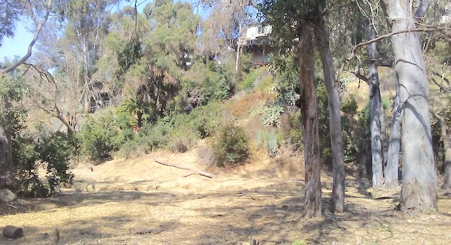
The canyon is full of past attempts to control the downhill waters. The high edges of the canyon are lined with houses, and the sides of the canyon are marked by washes carved by the downhill flow of drainage.
“The story of this canyon is long and strange,” says McMakin. “We are in a continuum from being a leftover piece of unbuildable land to being official dedicated open space…. If the right resources were put into this it could be a remarkable spot.
D’Elgin has been securing grants to plan how to turn the canyon into a proper open space. They’re up against more than picking up trash: they have to develop a master plan that includes matters such as a stormwater drainage plan, a trail map, plans to eradicate the invasive plants, and how to fund all those things. Coastkeeper, the San Diego Regional Water Quality Control Board, the Coastal Conservancy, San Diego Canyonlands, and other groups are all helping the effort.
Just past the paving is a deep drainage ditch carved by the water. The low end has riprap boulders stacked across it to break up and deflect the force of rainwater flowing downhill. None of it even resembles the Storm Water Department’s best practices. Instead, water has carved steep, fast streams at random spots down the hillside and has gouged the bottom of the canyon as it continued downhill.
For now, the city is chipping away at its projects list and there may well be more spot-work like the paving. City records show it has two permits to replace 23,000 linear feet of drain pipes in one spot and another 3100 linear feet in another. They’re going to build new walls and cleanouts and shore up the slopes, the plans say. The permits, approved in October 2016, note that the projects are near environmentally sensitive habitat. The canyon looks well used — and offers a canopy of eucalyptus and native trees. It is full of arundo and castor bean, the region’s most prolific invasive plants. There’s less trash than you’d expect, and a half dozen people walked past in the first ten minutes — a mom with a stroller, a woman with her dog, two men with backpacks.
“This could be one of the most remarkable center city open spaces in the U.S.,” McMakin says. “It’s so dramatic, it’s so scenic, it has the historic landmark bridges over it.”