Sponsored
Sponsored
The Tijuana River Valley Regional Park (TRVRP) provides a wide variety of year-round recreational opportunities within its 1800 acres that include a bird and butterfly garden, community gardens, multi-use open-space turf area, and five ball fields. The park is part of the Pacific Flyway and is bisected by the east/west flowing Tijuana River. The broad, flat flood plain provides an ideal environment to study the diverse vegetation communities that attract transient bird populations as well as herptile species — lizards, skinks, snakes, whiptails, frogs, and toads. More than 340 bird species have been recorded — that is two-thirds of all bird species recorded in the entire county! The meandering trail system provides a lush environment ideal for exploring, with the Nature Observation Area around Dairy Mart Pond providing a well-developed area to introduce the wonders of the natural world.
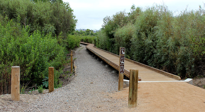
The north trailhead off Dairy Mart Road is the best place to park for visiting the Nature Observation Area, where there is an informational kiosk and the trails are well developed and compact. This area is people-friendly with benches along the trail as well as bird blinds perfect for watching the birds around North Dairy Mart Pond. In addition, a wooden boardwalk borders a nonnative grassland and southern willow scrub. Be on the lookout for snakes and other reptiles. You will see mixed-use trail-markers indicating the developed trails for your enjoyment.
The TRVRP is culturally and naturally rich. This southernmost part of the U.S.A. for centuries served as the fishing grounds by the Kumeyaay Indians. The flat river floor of this park consists of fill, alluvium, recent and old alluvial fan deposits, and terrace deposits. The area is prone to earthquakes and seasonal flooding. The diverse plant community includes: southern mixed chaparral, maritime succulent plants, native grasslands, coastal sage scrub, riparian plant communities, nonnatives, and disturbed habitat. The ponds and surrounding riparian wetlands provide habitat for songbirds, rails, waterfowl, and shorebirds.
Distance from downtown San Diego: 17.5 miles. Allow 25 minutes driving time (Imperial Beach). Take I-5 S and exit at Dairy Mart Rd. and turn right (south). Go south 0.3 mile, passing Servando Rd. on the right and Camino de la Plaza on the left. Just a few feet past Camino de la Plaza will be a “Parks and Recreation, County of San Diego, Tijuana River Valley Regional Park” sign on the right. There is a small parking lot with a trailhead kiosk that leads to the Nature Observation Area around the North Dairy Mart Pond and the Sunset Trail. The north trailhead accesses all of the regional park trails. There is a south trailhead kiosk 0.3 mile down Dairy Mart Rd. on the right. This trailhead provides access to the Beach Trail and all of the TRVRP trails. Continuing southwest, Dairy Mart becomes Monument Rd. There is a ranger station 0.2 mile down Monument Rd. on the left-hand side at 2721 Monument Rd. To get to the visitor center and equestrian staging area, go 0.7 mile west on Monument Rd. and turn right on Hollister St. Go 0.7 mile north on Hollister. Turn left at the Saturn Blvd. stop sign. The visitors’ center is the blue building on the right. The bird and butterfly garden are west of the visitors’ center. The equestrian staging area is ahead 0.3 mile west on Saturn Blvd. Continue 0.3 mile north on Hollister to Sunset. Turn left to visit the community garden area or turn right and go 0.4 mile to the sports fields on your right. To return to I-5, go back to the Sunset and Hollister intersection, turn right, and go north 1.4 miles.
Hiking Length: 22.5 miles of multi-use nonmotorized trails available.
Difficulty: Easy to moderate with little change in elevation. Nature Observation Area trails are wide with a compacted surface. Equestrians, bicycles, and dogs (on leashes) allowed. Open sunrise to sunset daily. Day-use facilities at the visitors’ center include pull-outs for trailers, corrals, and picnic tables. Facilities and water.