Sponsored
Sponsored
Barker Valley, sitting at the southern end of Palomar Mountain and between the peak of Palomar Mountain to the north and Lake Henshaw to the south, is one of the most remote and least-visited locations in the area. Whether for a day-hike or an overnight backpacking adventure, you probably will have this secluded little valley to yourself.
The hike starts with a scenic, though winding 7.8-mile drive to the trailhead. After passing the entrance gate just off SR-79, continue on a well-maintained dirt road. At 1.4 miles there will be a segment of paved, but deteriorating, asphalt road. There is an access control gate at 3.6 miles that may be closed after bad weather to prevent road damage. At 6.2 miles, the pavement ends and the dirt road becomes increasingly rough with the last mile possibly requiring a high-clearance vehicle. Note that at 6.8 miles there is an intersection with Half Way Road (9S06). Make sure on the return drive that this road is not taken, as a locked gate may be encountered before reaching the highway. At 7.8 miles from the highway, there will be a wide section in the road and the sign for Barker Valley. Park and do not block the road. If taking this scenic drive to the trailhead in spring, there may be displays of showy penstemon (Penstemon spectabilis) with their long stalks of light purple, trumpet-like flowers and occasional spiny, prickly poppy (Argemone munita), reminiscent of a sunny-side-up fried egg.
The Barker Valley trail is well maintained and easily followed with the first section gradually descending down the old roadbed of the Barker Valley Spur for 1.7 miles. Then, after a sharp bend to the left, the trail narrows and winds its way to the valley floor, 3.1 miles and 1000 feet below the starting point.
The trail is lined with manzanita, the ubiquitous chamise, and the closely related ribbonwood, so named after the strips of bark that peel like ribbons from its trunk. At times of the year the sides of the trail host a wide variety of wildflowers, including the purple trumpet flower of Canterbury bells, white pincushion, yellow wide-throat monkeyflower, and the diminutive red Fremont’s monkeyflower, growing just inches above the trail.
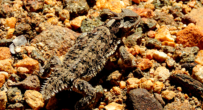
Glance down, as there may be a horned lizard, which resembles a miniature dinosaur, or tracks of mule deer on the trail. Looking up, there are often red-tailed hawks or other raptors soaring on the valley’s thermals in their endless hunt for small prey. The lucky observer may also spot bald eagles in the winter: they have been known to roost near Lake Henshaw.
Across the valley on the ridge to the north are the white domes of several of the California Institute of Technology’s Palomar Observatory telescopes, including the famous 200-inch Hale Telescope — for decades the largest telescope in the world. To the right on the ridge is the High Point fire-lookout tower. Built in 1967, at 67 feet, it is the tallest remaining Forest Service lookout in California.
Once on the valley floor you will soon reach the bed of the west fork of the San Luis Rey River. Here there are several choices; rest in the shade of one of the large coast live oaks and then return uphill for a 7-mile out-and-back trip. Alternatively, if time and energy allows, turn upstream and follow the trail to an open clearing, a nice spot if setting up camp for the night. Another option is turning south to follow the trail downstream for about a mile to discover a rocky area with pools, waterfalls, and more potential campsites where granitic rocks with ancient holes for grinding acorns (morteros) can be found by the observant hiker.
Distance from downtown San Diego: 86 miles. Allow 2 hours driving time (Warner Springs). From Ramona, go east on SR-78 to Santa Ysabel, turn left (north) on SR-79, and drive 21.5 miles. Turn left (west) onto Palomar Divide Rd. (S907), a narrow single-lane mountain road, and drive 7.8 miles to the trailhead on the left (west). Forest Service Adventure Pass required.
Hiking Length: 7 miles.
Difficulty: Moderate with 1000 feet of elevation gain/loss. Dogs (on leashes) allowed. No facilities.