Sponsored
Sponsored
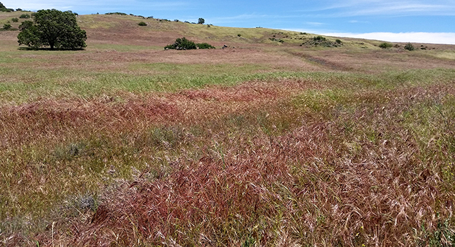
Most visitors to Cuyamaca Rancho State Park see the reservoir, hike Cuyamaca and Stonewall peaks, and visit Green Valley, but fewer set out for the East Mesa, which is strange because this area contains some of the most spectacular and varied terrain in the park. This trail has it all — views of the mountains in the park and the Lagunas to the east, rolling grasslands, dense pine forests, shaded streams, and a steep descent into a rocky gorge, but it is not a hike for beginners. In the spring it abounds with flowers and is almost overgrown in places due to infrequent use. This hike can be done in one long day or as an overnight at the Granite Spring backcountry campground. There is also the option of two smaller loops for less mileage.
The trailhead is at the parking area. Look for the signed Harvey Moore Trail that starts off to the southeast and ascends steeply up 400 feet to a saddle with a nice view of Oakzanita Peak to the south. A trail branches off left (northeast) after 1.6 miles. (This can be taken 1.3 miles back to the trailhead for a short loop or linked up with the Juaquapin Trail for a longer loop past the park headquarters.) Continue up through oak forest to the lovely rolling grassland of the East Mesa. Don’t forget to look over your shoulder for views of Cuyamaca and Stonewall peaks. Pass the Dyar Spring Trail on the left (north), 1.1 miles after the last junction. (The Dyar Trail links back to the Juaquapin Trail for another potential shorter loop back to the trailhead.) Continue up the grassy slopes to the saddle where you are rewarded with a sweeping view of the Laguna Mountains off to the east.
The trail curves down and north, joining the East Mesa Fire Road and eventually the Granite Spring campground, 1.6 miles past the Dyar junction and 4.3 miles from the trailhead. The Granite Spring site has pit toilets, tent sites, horse corrals, and non-potable water.
From the campground, head north up a hill back onto East Mesa, most of which is in a state wilderness area. The trail follows along an old fence to a grove of pine trees where, about 1 mile after the campground, it takes a sharp bend right (east). At this point, take the Harvey Moore Trail junction left (at an old gate, downed log, and faded sign). Wander through the shaded glen, often bursting with wildflowers. The trail soon takes a steep dive into the Harper Creek drainage along rocky switchbacks. Cross the creek and then parallel it as the trail hugs the northern slope of this steep rocky gorge. After 2.2 miles the trail emerges back into the flat lush Sweetwater River valley. Follow the East Side Trail past the park headquarters 2.2 miles back to the trailhead.
As you are hiking, there may be wild turkeys in the area. About 300 of them were introduced into the county by state officials and members of Safari Club International and the Wild Turkey Federation in 1993. Safari Club International paid to have the turkeys hauled to San Diego County from Kansas. With no major predator and abundant food sources, the turkeys have thrived with a population today estimated to be as high as 20,000 ranging from Riverside County to the Mexican border in rural areas. The turkeys are a hybrid mix of a subspecies of Texas Rio Grande and a subspecies of Eastern, common to the Midwest. They roost in trees at night and eat nuts, leaves, and insects. Cuyamaca Rancho State Park is a wild-turkey hotspot. Perhaps they know that they are protected from hunters within the state park.
Distance from downtown San Diego: 47 miles. Allow one hour driving time (Cuyamaca Mountains). Take I-8 E and exit at SR-79/Japatul Valley Rd. Drive north on SR-79, 7.7 miles to the large parking area on the right (east), just before the Sweetwater Bridge and one-half mile past the Green Valley Falls Campground.
Hiking length: 9.8-mile loop, with potential overnight at Granite Spring campground.
Difficulty: Strenuous. Elevation gain/loss: 1100 feet. Trails are rocky. Facilities at the trailhead and at Granite Spring campground. Contact Reserve America for reservations at reserveamerica.com or call 800-444-7275. Untreated water at Granite Spring.