Sponsored
Sponsored
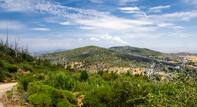
Although Cuyamaca Peak, at 6512 feet, is the second highest peak in the county, its location gives it an unsurpassed 360-degree view that is hard to beat, extending from the Coronado Islands in Mexico to desert mountains in Arizona, as well as to the tallest Southern California mountains in Los Angeles and San Bernardino counties. The hike to the top of the peak is one of the most popular hikes at Cuyamaca Rancho State Park. There is always something interesting to see, but for best views, come after a rainstorm.
From the day-use parking area in the Paso Picacho campground, walk to campsite No. 69, where there is a short trail heading to the Lookout Fire Road. Both the peak and the fire road leading to it are visible from the campsite. Follow the paved trail. Every possible trail junction is adequately signed, so it is difficult to get lost or make a wrong turn.
A paved road can become monotonous; however, there is an abundance of interesting plants and animals living beside the road. Depending on when you go, there may be monarch butterflies visiting the milkweed plants commonly found growing here. Also, when in bloom, the native lilac bushes can put on a colorful floral display, as can the pink bract manzanita that grows here. Other flowering shrubs here include the Sierra gooseberry, wooly blue curls, and chaparral bushmallow. Annual wildflowers include lupines, cryptantha, locoweed, baby blue eyes, phacelia, and San Bernardino asters. Later in the spring and summer, several kinds of goldenbush ragweed and goldenrod lend color to the journey. Deer Spring is on your left, approximately 2 miles into the hike, flowing even in a drought year. Here, look for western blue flag iris, as well as rushes, willows, and other water-loving plants.
Most large trees in the area, including black oaks, pines, and incense cedar, were killed in the 2003 Cedar Fire. The park service has cut down many of the dead trees and planted numerous Coulter pines. Also, there has been considerable natural regeneration of pines and black oaks from seeds that germinated after the fire, but most of these trees are small compared to what was there before the fire. There are a few unburned areas that were either protected by firefighters from the 2003 devastation — such as the Paso Picacho campground itself — or were just fortunate and escaped the capricious flames.
In addition to the campground, much of the forest at the top of Cuyamaca did not burn, so once you reach the peak, there will be some shade. The trees, however, may hide views in some directions. Just keep exploring the mountaintop to be certain that these extraordinary views are not missed. The best viewing usually is found after a winter storm when there is no difficulty seeing 100 miles in all directions, if not further. After exploring the peak area, return the way you came.
Distance from downtown San Diego: About 52 miles. Allow 1 hour driving time. Take I-8 east to its junction with SR-79 near Descanso, a distance of about 40 miles. Exit I-8 and go north on SR-79, 11.8 miles to the Paso Picacho campground in Rancho Cuyamaca State Park. Park in the day-use area to the right of the entrance and pay the day-use fee. Facilities and picnic tables available.
Hiking length: 5.6 miles out and back.
Difficulty: Moderately strenuous because of 1500 feet gain/loss following the paved Lookout Fire Road. The fire road is only open to authorized motor vehicles and is open all year. It is one of the few trails in the park where dogs are allowed on a leash. The trail also is open to mountain bikers and equestrians.