Sponsored
Sponsored
Pyles Peak is mid-way between Cowles Mountain on the south and Fortuna Mountain on the north and is part of a series of peaks that was called Long Mountain on some older maps. It has some unrestricted views of the north, east, and west sections of San Diego. The name of the peak dates from 1989 and is probably named for the Pyle family that has been active in conservation circles, according to Leland Fetzer, author of San Diego County Place Names A to Z.
Pyles Peak is accessed through Cowles Mountain, which has three approaches. The most common is the south approach on the corner of Golfcrest and Navajo Road in San Carlos, which is the recommended approach. At 1591 feet, Cowles Mountain is the tallest peak within the city limits of San Diego.
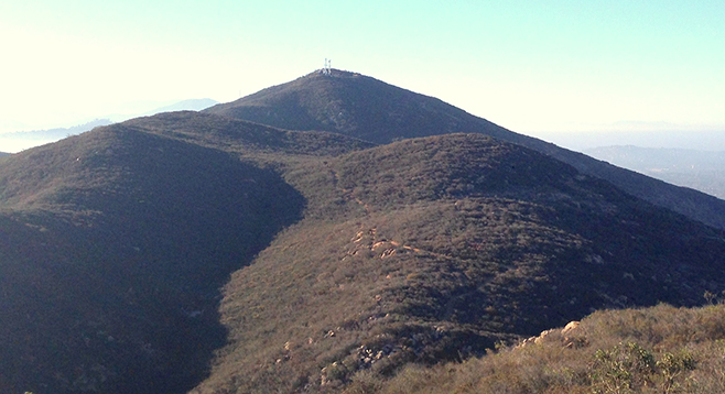
The 1.5-mile trail to the top of Cowles is well marked and is regularly used by nearby residents and at times with their dogs. Upon reaching the summit from any of its three approaches, face north and walk onto the service road that hugs the descending side of the summit. Turn left and walk briefly to its western end where the Pyles Peak trailhead is found on the left. This trail is less traveled.
The Pyles Peak trail is generally well marked and maintained, making for a leisurely and occasionally challenging hike. The trail descends into the chaparral in a northerly direction, followed with multiple ascents and descents along the ridgeline before reaching its destination. The chaparral is low and sparse, dominated by chamise, mission manzanita, and laurel sumac. The elevation, distance from habitation, and the absence of hikers provides quiet, making the call of the occasional wrentit stand out. Scrub jays and Anna’s hummingbirds are frequent companions.
Nearing Pyles Peak, the trail drifts westerly for a bit where a well-marked lookout spot on the lower western corner of the peak is visible. The final ascent to the 1379-foot summit begins here and is fairly straight up to the top. The trail narrows with a loose gravel base, which will challenge even experienced hikers. The reward is an unobstructed view to the north and east, with the Cuyamacas and Lagunas as backdrops.
The return is just over 3 miles, with the first leg to Cowles Mountain a mostly upward hike of 1.6 miles, then a descent for about 1.5 miles back to the trailhead on Golfcrest and Navajo Road.
Distance from downtown San Diego: 13 miles. Allow 20 minutes driving time. Take CA-163N and merge onto I-8E. Exit I-8 at College Ave. and drive north 1 mile, turning right onto Navajo Rd. Continue 2 miles on Navajo Rd. to the Cowles Mountain trailhead on the northeast corner of Navajo Rd. and Golfcrest. Park in the small lot or on the street.
Hiking length: 6.2 miles out and back. Allow 3 hours.
Difficulty: Moderately strenuous because of steep ascents and descents. Elevation gain/loss of 2000 feet. Leashed dogs allowed on trails. Facilities on the corner of Golfcrest and Navajo Rd. in San Carlos. Best in the morning, to avoid heavy use of the Cowles Mountain route. No shade. Trekking poles recommended. Best from October to May, when temperatures are cooler.