Sponsored
Sponsored
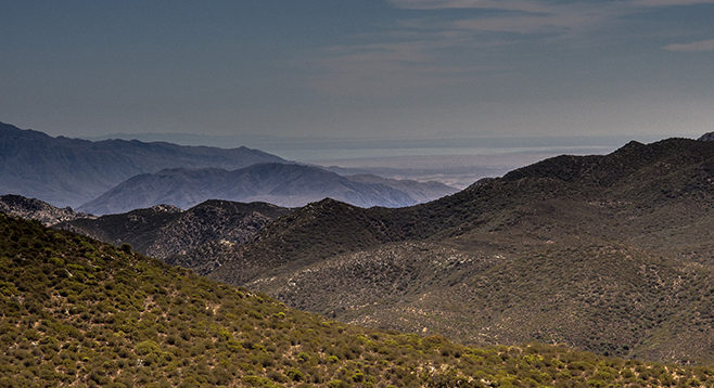
Combs Peak is the fifth highest peak in San Diego County and also one of the most remote. Surprisingly, it is in the Anza-Borrego Desert State Park. From this lofty summit there are views of the two highest peaks in Southern California — San Gorgonio and San Jacinto. There is also a view of the second lowest point on the North American continent — the Salton Sea. The sea’s surface is 227 feet below sea level, 55 feet higher than Death Valley.
A sign designating the PCT marks the trailhead. It indicates that it is 6 miles to the Riverside County line and 24 miles to the nearest facility at Paradise Café. Start hiking north on the PCT as it makes its way up a relatively gradual slope from Lost Valley Rd. to an unnamed saddle, gaining about 600 feet of elevation in 1.8 miles. The Coyote Fire struck this area in 2003, incinerating the scattered Coulter pines that grew among the ribbonwood and chamise-dominated chaparral. Members of the rose family, both ribbonwood or red shank and chamise are the same genus, Adenostoma, with ribbonwood numerous only in small local areas. Both are remnants of ancient vegetation that existed in Southern California before modern chaparral. Leaves are similar in size, although chamise leaves are close to the stem and conspicuously resinous. They both resprout well after a fire. Since the 2003 fire, the chaparral shrubs have made a comeback, particularly on the lower and east-facing slopes. In addition to a few ribbonwood sub-trees nearing 15 feet in height, there is holly leaf redberry, several species of ceanothus, Mexican manzanita, sugar bush, scrub oak and mountain mahogany. Numerous seedling Coulter pines make an appearance near the saddle, but there are no mature pines until the peak, where a single, relatively large pine managed to avoid death by wildfire. Watch for poison oak on this hike and check for ticks.
Once at the saddle, leave the PCT and begin a more arduous but shorter journey from the saddle to the peak over a rarely trod trail, gaining another 600 feet of elevation in half a mile. Many PCT through-hikers camp at this saddle, as it is one of the few relatively flat areas for miles. Look for an obvious camping spot on the left as you cross the saddle. The trail starts west of this camping spot and goes up the ridge. The trail is not always obvious but is well marked with small stacks of rocks, three or more (called either a cairn or duck), to point the way. Once on the peak the reward will be some amazing views, if the weather cooperates. Return the same way, taking care when descending.
Note: Trail angels may provide a drinking-water stash for PCT through-hikers. Please do not use this water unless a PCT through-hiker. Bring enough water for this outing.
Distance from downtown San Diego: About 94 miles (Chihuahua Valley). Allow 2 hours driving time. From Warner Springs, continue north on SR-79, 11 miles past Warner Springs to Chihuahua Valley Rd. Turn right and go east on Chihuahua Valley Rd. an additional 6.3 miles. At this point, Chihuahua Valley Rd. makes a 90-degree right turn. Don’t turn. Continue straight ahead onto the unpaved road that is Lost Valley Rd. Very soon, this road seems to split, with a well-graded road leading off to the left while a rougher dirt road goes off to the right. Take the road to the right and continue for 5 miles. The Pacific Crest Trail (PCT) crosses Lost Valley Rd. near this point. Park on the left where there is room for a few vehicles to begin the hike.
Hiking length: 4.6 miles out-and-back.
Difficulty: Moderate with an elevation gain/loss of 1200 feet, mostly over the well-maintained PCT, but with a relatively short strenuous segment of cross-country climbing. Trekking poles are advisable. There are no facilities or water.