Sponsored
Sponsored
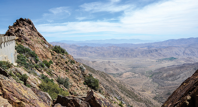
This short segment of the Pacific Crest Trail follows a wide ledge that was hacked out of the near cliff that was once part of the original Sunrise Highway. The ledge drops several thousand feet to the Anza-Borrego Desert below. This segment of the road must have been difficult to maintain and possibly dangerous for motorists. The highway was rerouted to a safer, though less spectacular location, on the other side of a nameless hill in the 1970s. The pavement was largely removed when this became a segment of the Pacific Crest Trail. This trail is one of the most spectacular places to view the transition from mountains to desert. It is also a popular place for trail runners and for hang gliding.
If interested in only visiting Kwaaymii Point and not going on this short hike, then instead of starting at the Pioneer Mail Trailhead, drive to milepost 30.3 on the Sunrise Highway and turn onto Kwaaymii Road on your right. Drive just 0.3 mile down the paved road to its end to arrive at Kwaaymii Point. Parking here doesn’t require an Adventure Pass because it is in the Anza-Borrego Desert State Park rather than in Cleveland National Forest.
From the Pioneer Mail Trailhead, head north on the trail which has all the characteristics of a dirt road as it leads up the slope through low-growing chaparral consisting of shiny-leaf yerba santa, manzanita, buckwheat, chamise, mountain mahogany, and scattered scrub oaks. Continuing up the trail, the drop-off on the right becomes more dramatic and a sense of appreciation begins to grow for the effort that was necessary to chisel a road into this increasingly steep slope. Soon you will be gazing out over a cliff with an unbroken 3000-foot drop down to the floor of Cottonwood Canyon and Mason Valley. The Pinyon Mountains rise up on the other side of the valley and, in the hazy distance, the massive Santa Rosa Mountains loom over the horizon. After a fall or winter storm, the view will be even more spectacular, as you will be able to see much farther.
Kwaaymii Point itself is an aggregate of uplifted, colorful metamorphic rocks, probably Julian schist. These rocks have been used to memorialize a number of fairly recently departed individuals who appear to be known only to their friends and family. The point itself is named for the Kumeyaay band of Indians that lived in the Laguna Mountains and had a reservation there. The Laguna Reservation reverted to private ownership of the Tom Lucas family several years ago. The PCT continues north from Kwaaymii Point an additional 2400 miles. This is a good place to retrace your steps back to the Pioneer Mail Picnic Area.