Sponsored
Sponsored
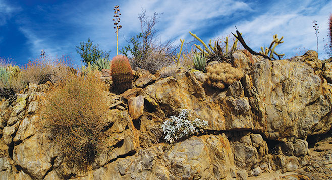
Cool Canyon is unlikely to be cool most of the year as far as the daytime temperature is concerned, but it is definitely cool in the colloquial sense. Hike up this east-west–oriented canyon and observe the change from the Sonoran desert scrub vegetation of Earthquake Valley to the foothill chaparral transition zone where you will find junipers and manzanita in an otherwise arid desert setting. The geology is fascinating, with large exposed expanses of colorful metamorphic schist with numerous intrusions of igneous granite and quartz.
There are no signs other than warnings that dogs and horses are not allowed, and there is no official trail. From the end of the road, start walking up the sandy Cool Canyon wash. The vegetation near the start of the hike includes Mojave yucca, burrobush, cheesebush, creosote bush, ocotillo, and catclaw. Sunflower-like plants commonly in flower here include brittlebush and Parish’s goldeneye, and while in season, there may also be flowering desert apricot and a variety of colorful flowering cacti, including Gander’s cholla, beavertail cactus, hedgehog cactus, and California barrel cactus. Blooming wildflowers might include apricot mallow, tidytips, sweetbush, chia, and phacelia, along with many others. The first mile is easy walking in soft sand with occasional small dry falls. The canyon walls include frequent outcroppings of colorful metamorphic Julian schist, a rock formation that held the gold that attracted miners to the Julian area in the 19th Century.
There is a more formidable barrier about one mile from the trailhead where a series of somewhat larger dry falls are encountered. If concerned, this might be a good place to turn back. The dry waterfalls can be surmounted without climbing skills, but a little bit of care is necessary. The canyon branches beyond these obstacles. Take the canyon to the right that heads in a westerly direction. Here the sandy walk continues with only a modest amount of boulder-hopping. On your left is a beautiful old California juniper with a gnarled trunk and a big berry manzanita growing next to it. Junipers are common here, as is agave, but manzanita is relatively rare.
At a little over 1.5 miles from the start of the hike, there will be thick brush in the canyon bottom. One option is to navigate up onto the ridge on the right and continue to the point where Earthquake Valley can be viewed. A more adventurous alternative would be to hike to the top of Granite Mountain from here, but that is beyond the scope of this trip. This also may be the best place to turn around and head back.