Sponsored
Sponsored
The elephant tree (Bursera microphylla) is rarely found in the United States. It is found in the Gila Range of Arizona and, more commonly, in Baja California and Sonora, Mexico. For many years it was thought not to exist at all in the United States. The first sighting in the Colorado Desert was made in 1911, but its exact location remained a mystery until an elephant tree hunt occurred in 1937 and representatives from the San Diego Natural History Museum and the state park officially recorded this site. Since that time, other stands have been found in the Santa Rosa Mountains near Clark Dry Lake, Indian and Bow Willow canyon areas, Bisnaga Alta Wash, Fish Creek Mountains, and In-Ko-Pah Gorge. (See the “Roam-O-Rama” column for Bow Willow to Mountain Palm Springs for a hike to Torote Bowl, where about 15 elephant trees can be found.)
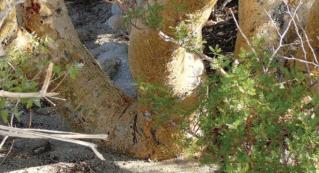
The tree is usually found in rocky areas and on slopes. The common name derives from its swollen trunk, which stores water and has the resemblance of an elephant’s thick, massive leg. It stands 6–10 feet tall and can reach heights of 20–30 feet. The tree has low spreading branches, a yellowish paper-like shedding bark, copper-colored upper branches, green leaves, white flowers, purple fruit, and exudes a pinkish/red resin. It has a strong pungent smell reminiscent of turpentine, pine needles, and tangerines and is in the same family as myrrh and frankincense of the Middle East. It had the same sacred and special medicinal value to Native Americans as myrrh and frankincense had to the early Arabic and Judaic cultures who also found it economically important as a source of incense and perfume. In Mexico it is known as torote, from the Spanish verb torcer, “to twist” — referring to its gnarled branches.
The trail is well-marked and has 13 numbered posts that relate to a free interpretive nature trail guide available at the turnoff to Elephant Tree Trail from Split Mountain Road or at the park’s visitor center. The guide is a good way to learn about common desert plants and strategies they have to survive in the desert. For those interested in annual wildflowers, this is the first place to check each season, as annuals will flower at the lower and hotter elevations first.
The trail has changed from previous years due to flash-flooding in the wash. There is now only one tree on this trail, and it is actually a shorter hike now than it was previously. Large piled rocks and boulders on the sides and in the wash testify to the force of running water and its ability to reshape trails that are in washes. At about the half-mile point, note the many downed ocotillos that were toppled over in a flash-flood. Also look to the northwest for a tall tree that stands out on the side of the wash. That is the lone elephant tree found on this hike a little further at mile 0.65. The tree is large, standing almost 15 feet in height. Other plants that will be noted on this hike include creosote, burrobush, desert lavender, cheesebush, ocotillo, indigo, smoke trees, acacia, and cholla. The trail continues to loop around the wash, rejoining almost at the trailhead at signpost number 2.
Since this is a short hike and a long distance to drive, it could be combined with one or two other short hikes by Tamarisk Grove, off SR-78, that appeared in this column last year. See Cactus Loop (2/21/2013) and Yaqui Well (2/28/2013).