Sponsored
Sponsored
The top of 1094-foot South Fortuna Mountain has sweeping views of all of the major peaks found in the City of San Diego’s largest regional park. South Fortuna is part of a long arced mountain with two peaks that was once called on century-old maps Long Mountain. North Fortuna, at 1291 feet, is separated from South Fortuna by a 910-foot saddle. This long mountain provided physical fitness training for U.S. Marines when Camp Elliott was active. It is still a great place for a workout with many possible approaches and loops possible.
Although not the tallest of the two peaks, South Fortuna has one of the best views and is the most challenging when approached from the south ridge. Instead of switchback that would make the climb easier, there is a steep staircase of about 300 steps fashioned from 4x6-foot timbers and rock leading up to the bench from which there is an easy stroll to the summit.
Begin the hike at the trailhead at Jackson Drive and Mission Gorge Road and follow the wide path to the northwest that is part of the MTRP Visitor Center (VC) Loop Trail. At one point in time, this trail was being considered as an extension of Jackson Drive that would head to Hwy 52.
In less than a half-mile into the hike will be the trail to the right or east that heads to the VC. Straight ahead is the San Diego River crossing. Flowing water here fluctuates seasonally. To avoid getting wet and muddy crossing the river if the flow is high, take a tree-covered path to the left near the junction with VC trail that leads into the riparian area. Walk across a cement piling to a concrete slab path that will reconnect on the opposite side of the river. The riparian area has a variety of trees and shrubs, including mule fat, sycamores, and willows and juncus, which were used by the Kumeyaay for making collection baskets. Watch out for poison oak near the trail.
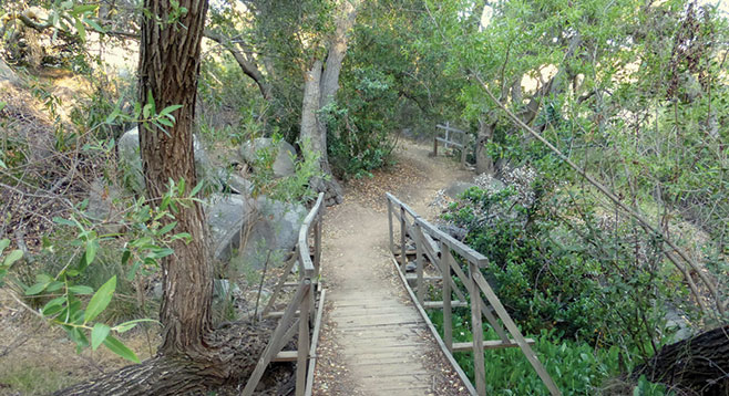
Begin looking for junctions and take all right turns. At about a mile into the hike, go right to head downward toward Suycott Wash; then take another right immediately at mile 1.05 that is signed “Suycott Wash/South Fortuna Mountain Trail.” Follow the trail and signs to yet another junction at the Suycott Wash Trail. Go right to begin the South Fortuna trail, which will lead across a small bridge through an oak woodland with old-growth oaks.
The trail will turn to the left to approach the south ridge of South Fortuna. As elevation increases, the surrounding habitat changes from oak woodland to grassland to sage scrub as the steep wood staircase is climbed close to 560 vertical feet in little over a half-mile to reach the top. Enjoy the view at the top of the staircase at the marked “viewpoint” for one of the best vistas in the park at 1000 feet above Mission Gorge. To the southwest are three tall peaks within MTRP, beginning with the closest that include 1194-foot Kwaay Paay Peak, 1379-foot Pyles Peak, and 1591-foot Cowles Mountain, which is easily recognized because of the antennas on top. North Fortuna is in the opposite direction. After taking in the view, follow the now-flat trail to the real summit at just over 2.5 miles from the start of the hike.
From the summit, hikers can backtrack to the start or continue by following the trail to the saddle for about half a mile. From the saddle, take the steep trail down that leads back to Suycott Wash. At the junction with the wash, turn left and hike past the picnic area to complete the loop. Follow the trail back to the Jackson Drive trailhead.