Sponsored
Sponsored
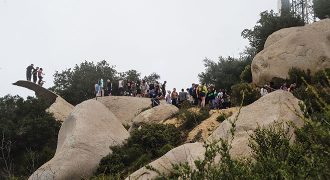
Mt. Woodson has become one of the most popular hikes in San Diego County since Potato Chip Rock made its appearance in YouTube videos. On a typical weekend, there may be a hundred or more people who have hiked up from Lake Poway, milling around this famed rock, waiting for their turn to scamper out on the ledge and capture a photo of their adventure. However, Mt. Woodson has many other things to offer outdoor adventurers if they take the time to experience them. The 3.75-mile out-and-back hike to the top from SR-67 is much shorter and shadier than the route from the Blue Sky Reserve.
If the hike is extended to Potato Chip Rock, it adds another mile to the journey to the peak. An even more interesting possibility is the 5.5-mile loop hike described here that includes the experience of the diverse terrain and life of this unique area. Any of these routes would be considered moderately strenuous because of the trek to the top of the mountain, 1100 feet above the trailhead.
The well-marked trailhead is on the south side of the Cal Fire Station access road, a few feet from SR-67. The hike begins as a short trail through a live oak and sycamore woodland that leads to the paved road that will be the route to the top. Live oaks and occasional Coulter pines periodically shade the road during the steep ascent along with enormous boulders composed of Woodson Mountain granodiorite, a light-colored intrusive rock that weathers into rounded shapes when exposed on the surface. The abundance of these huge boulders has made this a popular place for rock climbers.
More than 50 common chaparral shrubs and wildflowers have been found growing beside the road on the way to the top. These include three kinds of manzanita, laurel sumac, yerba santa, flat top buckwheat, California sagebrush, golden yarrow, white sage, scarlet larkspur, Indian pink, and chamise. The top is 1.75 miles from the SR-67 trailhead. The pines, huge boulders, and a forest of communication towers tend to obscure views from Mt. Woodson’s summit. Continue west down the ridge, leaving the asphalt road, and follow a well-traveled dirt trail where, weather permitting, there are outstanding views of San Diego, Point Loma, and the ocean. Most likely there will also be a crowd waiting to climb out onto Potato Chip Rock, particularly on weekends. Further down the ridge will be the signed junction for the Fry-Koegel (F-K) Trail, 1.3 miles from the summit.
The F-K Trail is the 2.7-mile route back to your parked vehicle on the loop hike. Initially the F-K Trail passes through lush chaparral, dominated by scrub oak, chamise, California sagebrush, manzanita, and ceanothus, fully recovered from a fire seven years ago. Continuing down this well-maintained trail, there is a transition to a cool, shady, coast live oak woodland before reaching the western boundary of Mount Woodson Estates, a suburban development. Follow the trail to the right to skirt the backyards of numerous homes as it leads to SR-67 at a point just beyond the entrance to the Mount Woodson Golf Club. From there it is a short noisy walk south beside the highway to the Cal Fire Ramona station.
The mountain is open year around. The best time to go is when the chaparral shrubs and wildflowers are in bloom, from March through June. If going during the warmer days of summer or fall, plan to hike in the early morning, before the heat of the midday.
Distance from downtown San Diego: 31 miles. Allow 40 minutes driving time (Ramona). From CA-163N, merge onto I-15N, then east onto Scripps Poway Pkwy. Turn left/north on SR-67. Drive past the Cal Fire Ramona Station at 16310 SR-67 (3 miles past the junction of Poway Rd. and SR-67) until you can safely turn around to park on the SR-67 shoulder near the fire station on the Mt. Woodson side of the highway heading west.
Hiking length: 3.75 mile out-and-back or 5.5-mile loop.
Difficulty: Moderately strenuous with 1100 foot elevation loss/gain. The road is open to hikers, with or without dogs, equestrians, mountain bikers, and vehicles owned by various agencies that operate the many communications towers that crown the peak. No facilities or water.