Sponsored
Sponsored
In 1907, General Land Office (GLO) survey records note “Mid Peak” as the peak between North and Cuyamaca peaks. It was not until 1970 that “Middle” Peak appeared on forest maps. Middle Peak used to feature Cuyamaca’s “big trees” until the Cedar Fire. It is slowly recovering. The attraction now is the open view.
To begin the hike, cross SR-79N onto Milk Ranch Road, passing the return to SR-79N, then keep to the right, taking the walk through at the gate. The left road goes to the burned remainder of camp Hual-Cu-Cuish, Kumeyaay wording for “tough (or strong) but flexible.” Built by the California Conservation Corps (CCC) in the 1930s and then used by the Boy Scouts from 1940 to 1998 as a camp, the area burned in 2003 Cedar Fire. The fire burned 90 percent of Cuyamaca Rancho State Park with some areas so hot that tree roots burned. The Cedar Fire covered over 273,000 acres, burning desert and mountain areas and extending west of SR-163 with spot burns as far as I-805.
Once past the gate and approximately 0.3 mile from the parking area, turn right onto Middle Peak Loop Fire Road, which gains elevation via multiple switchbacks. Catch your breath by looking back with clear views of Paso Picacho Campground, Lake Cuyamaca, plus Stonewall and Cuyamaca peaks. Turn left onto the east section of Black Oak Trail after 2.2 miles, descending through burned trunks of pines and oaks to return to Milk Ranch Road.
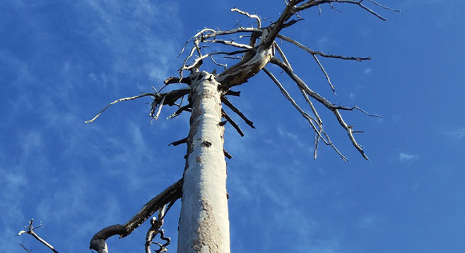
Turn right for a short distance of 0.1 mile to the log-blocked crossroads of Azalea Spring Fire Road/Milk Ranch Road/Black Oak Trail (west). A rest against the raised log makes for a good break. Ascend back to the Middle Peak Loop Fire Road by crossing Milk Ranch Road onto the west section of the Black Oak Trail. On a clear day, the view to the west includes Mount Woodson, with its multiple antennas, and Viejas and El Cajon mountains. A section of the trail is bordered by a ten-year growth of ceanothus and a tree trunk at waist height. Your choice whether to pass under or over the trunk. Among the Jeffrey pine skeletons are a couple of examples of the tall, wide trunks with a crown snaggle of branches of what was a remnant population of mature sugar pines.
The trail ends at the Middle Peak Loop Fire Road. Turn right, then pass the Sugar Pine Trail on the left, then the east Black Oak Trail on the right to return to Trout Pond off-road parking.
An alternative shorter hiking route is to stay on Milk Ranch Road and then ascend the west Black Oak Trail before returning to Trout Pond either by Middle Peak Loop Fire Road; or descend on east Black Oak Trail, turning left on Milk Ranch Road.
Distance from downtown San Diego: 53 miles. Allow 60 minutes driving time (Cuyamaca Rancho State Park). From SR-163N, exit onto I-8 E. Take SR-79N/Japatul Valley Rd. (Descanso), turning left, toward Julian, at the end of the ramp. After just under 3 miles, turn left to follow SR-79N for approximately 10.5 miles. Park off road at Trout Pond across from Milk Ranch Road, just before SR-79N turns right. No facilities.
Hiking length: Approximately 8 miles with an option of 6 miles. Difficulty: Moderately strenuous with 1100-foot elevation loss/gain. The trail is mostly narrow and rocky once leaving the fire road(s). Bikes allowed on Milk Ranch Road and Middle Peak Loop Fire Road. Snow is a possibility during the winter months.