Sponsored
Sponsored
The Tijuana Estuary is one of the few estuaries in Southern California that has natural, daily tidal flushing that enables this wetland to be among the most biologically productive systems. The trails described are in the north section of the Tijuana River National Estuarine Research Reserve, one of 35 designated “Wetlands of International Importance” in the United States, per the Ramsar Convention of 2005.
The trails are well marked and easy to follow out. Return on the same trail. Trails are laid out to protect the multiple habitats that include salt marsh, coastal sage scrub, maritime succulent scrub, dunes, and riparian. These differ in amount of water, salt content, and soil types. Inches of elevation can also add to the habitat differences where indicator species differ from one section to another. Margins of habitats are active as different food sources attract multiple birds and insects. Knowing bird-feeding preferences, nesting sites, and behavior improves enjoyment of this wetland.
Visit the visitors center, where there is a stand with free maps and pamphlets to browse, plus current information on any scheduled walks or updates in the area. Just south of the center there is a native plant garden that includes a low ground mat of heliotrope with curved double rows of small white flowers with purple centers, flat-top buckwheat, California sagebrush, and lemonade berry. The path southwest of the center has a view of a wooden trestle — all that remains of a structure built after WWII to support a sewage-outfall pipe to the mouth of the river when the military no longer used the area for coastal defense.
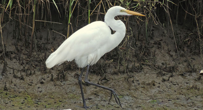
Walk south on the N. McCoy trail, named after Dr. Mike McCoy, who along with biologists Joy Zedler and Paul Jorgensen worked to build support for preserving the estuary in 1971. Pass over the bridge and notice two plants — pickleweed and alkali heath — that tolerate the high salt content of the marsh. The pickleweed has segmented fleshy stems that store the salt until concentrated and then break off when full. The flowers are very small and yellow in color with the leaves reduced to scales. The alkali heath shrub, with its tiny pink flowers, grows on alkali flats or in salt marshes and excretes salt. Watch for egrets, curlews, and night herons feeding along the inlets.
Backtrack over the bridge, turning east, then south along houses and an active naval aviation training facility. Continue on the River Mouth Trail to the end, then west at the water to view shorebirds. Reddish egrets are uncommon and look like they are dancing when feeding.
Return to your car, then drive to Imperial Beach Blvd., turning right to Seacoast Dr. until the end and park. Along the east side of the street, there are small patches of Salt Marsh Bird’s Beak, an endangered annual hemiparasite that is only found in ten locations. Continue down the road to the viewing deck, then cross to the Pacific Ocean shore and turn south to the Tijuana River mouth to watch the birds. It was here that Alan “Dempsey” Holder pioneered California big-wave surfing over a mile from the shore from 1930 through the 1950s. Backtrack to the car to complete this walk.