Sponsored
Sponsored
Bring binoculars and your smartphone on this walk! Park at the Grand Avenue Bridge overlook, and after viewing the area and the birds, imagine in the 1920s there was a Navy emergency airfield named San Dieguito Field, which was alluded to by Bing Crosby in “Where the Turf Meets the Surf”: “...take a plane...” During WWII there were two blimps at the airfield in support of the anti-submarine patrols. The airfield was assigned to the Navy until it was returned to civilian control in 1947, when it was named Del Mar Airport. PSA Flights were $16 from Burbank to Del Mar and back. It was closed in 1959 for the I-5 right-of-way with a remnant of a blimp mooring dock circle seen on the west side until 2006.
Walk northwest, turning right on Jimmy Durante Blvd. until directly over the bridge, then make another right turn to the large San Dieguito River Park sign. This is the current start of the Coast to Crest Trail that follows the San Dieguito River watershed for 55 miles from the source on Volcan Mountain. There are 33 miles of the trail completed, with 12 maps covering 14 trails listed at www.sdrp.org/home.htm and a QR scan code to download information at 20 locations along the first two miles of the trail’s beginning.
The first section is named the boardwalk, where you can see current and remnant urn-shaped swallow nests attached on a vertical section under the Jimmy Durante Blvd Bridge. They are built of mud pellets and fibers and are used by birds that fly with open mouths, scooping up both insects and water as needed.
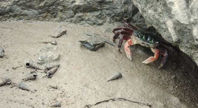
Near the shore is a mix of California horn snail shells, shore crabs with symmetric claws, and fiddler crabs named for the males that have one large claw. When waving it to attract females or picking up small chunks of sediment and moving to its mouth, it looks like it is playing the large claw like a fiddle. As they shift through the sediment for anything edible, these detritivores form small balls that are either scattered or stacked in piles along the waterline.
Continue on the Lagoon Trail under I-5, then past San Andres Drive where the path there is a slight incline onto the Salt Marsh Bird Trail; then follow the Horse Park Trail section and view the river as able when not hidden by the taller riparian plants. There is a riding school and horses in paddocks on the north side until El Camino Real, where you can turn left to follow the fence line to a stop sign and the Del Mar Horsepark entry. Turn around with the option of walking back on the Coast to Crest Trail portion above the Salt Marsh Bird Trail (though this section is under restoration and level with the cars so not as interesting at this time).