Sponsored
Sponsored
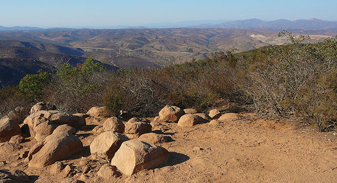
Kwaay Paay Peak is a good alternative to Cowles Mountain for anyone who wants a good climbing hike without a crowd. It is the fourth highest peak in Mission Trails Regional Park, at an elevation of 1194 feet. The name of the peak is from the local Kumeyaay Indian word referring to a leader, and a leader it is, in terms of its difficulty because of the vertical climb and elevation gain. The top of the peak is a large level area with many flat-topped rocks that allow one to rest and take in the panoramic view extending out to Miramar, Point Loma, and Coronado. Santee and La Mesa are below the peak.
There are two trails leading from Father Junípero Serra Trail. The recommended route begins across from the Mission Dam parking area (the Mission Dam entrance) and ends at the other trailhead on Father Junípero Serra Trail, 0.2 mile east, across from the entrance to the Kumeyaay Lake and Campground, which is known as the Bushy Hill entrance. The Mission Dam route is less steep and merges with the Bushy Hill trail at mile 0.7. At this point, there is a single trail to the peak. In addition to the Mission Dam route and the Bushy Hill Trail, there is the option of following a third trail back to Father Juñipero Serra Trail. Continuing on, the trail to the peak passes through some sage scrub and grassland habitats and continues to the peak through typical chaparral. Plants encountered en route to the peak include laurel sumac, chamise, California lilac, buckwheat, chaparral broom, sugar bush, black sage, nolina, and manzanita.
At mile 1.26, the steep trail reaches a small flat crest where there is a view of the gorge dropping down toward the visitor center. Two peaks are visible from here, as is the trail that heads straight up. Kwaay Paay is the second peak.
Now begins the really steep part that does not level off until mile 1.65. The return through this section is challenging and this is where trekking poles really make a difference. The peak is only 0.15 mile ahead from this point. After enjoying the views, head back down to the trail junction at mile 2.6.
There are three options at the trail junction. The trail to the left is the trail back down to Mission Dam. The middle trail is the signed Bushy Hill trail. The trail to the right is signed the Canyon and Lake Trail, which also leads back to the Bushy Hill entrance, but it is more interesting. Go right. The trail immediately heads down into the canyon and over a bridge. It climbs a small ridge and heads to a housing area, following a fence down to the junction with the Bushy Hill trail at mile 3.4. This route follows drainage where there are riparian plants such as mule fat, willow, sycamores, and oak. Note the mistletoe on the sycamores. Grasslands are found above the riparian area. The trail ends at Father Junípero Serra Trail.