Sponsored
Sponsored
The Indian Creek Trail is full of surprises but does not give them up too easily. The trail meanders through oak woodlands and down narrow canyons to streamside meadows, then climbs up to the chaparral, ending with magnificent views of the desert below. A trail for all seasons, it is exemplary in the spring for wildflowers, in the fall for the changing leaf colors, in summer for workouts, and magical after a winter snowfall. Plan your gear accordingly.
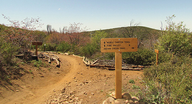
This description begins from the western (clockwise) approach. The trail and junctions are well marked with Cleveland National Forest signposts and distance markers. Parts of the trail are multipurpose, so keep an eye out for mountain bikes and horses. From Penny Pines, take the Noble Canyon trailhead west for approximately 2 miles, first gaining then losing elevation to reach the Indian Creek trail junction toward Champagne Pass. Go right at the Indian Creek Trail, down a series of switchbacks for about a mile to reach the namesake creek at a stream-crossing reminiscent of an alpine meadow with soft grasses and colorful wildflowers. This makes a good resting spot before embarking on the steepest climb of the trail — or as a turnaround point. At the top of a steep quarter-mile climb is Champagne Pass. This is the junction with Pine Mountain Trail on the right; go straight for the continuation of Indian Creek Trail. An unmarked narrow trail on the left, across from the Pine Mountain trailhead, goes uphill to the Champagne Pass Viewpoint barely 100 yards away. After catching your breath, it is worth the detour for a great 360-degree view of the surrounding peaks.
Returning to the junction, take the well-marked Pine Mountain Trail, heading north climbing toward Pioneer Mail approximately 1.5 miles away, across from Sunrise Highway. The Pioneer Mail picnic area has restrooms but no water. Here you will join the Pacific Crest Trail heading south (to the right) for a four-mile hike back to Penny Pines. The PCT runs parallel to and behind the picnic area. The signpost is on the far edge of the dirt parking area. Be sure to head south toward Garnet Peak and not in the direction of Kwaaymii Point. The trail continues to climb to the highest point on the hike at almost 5600 ft. Several spots offer great views of the Anza-Borrego Desert and the Salton Sea to the east. Hearty folks can take the short side-trip to Garnet Peak for a panoramic view of the desert and mountains.
This hike crosses several plant communities in close proximity, from mixed conifer-oak woodlands to riparian (streamside) habitats, to chaparral transitioning into desert. Among notable trees and shrubs are Jeffrey pine, black oak, chokecherry, mountain mahogany, service berry, chamise, mountain manzanita, and ceanothus. Perennials and spring flowers include bush poppy, buttercup, meadow rue, yucca, summer snow, baby blue eyes, mountain violet, scarlet bugler, sun cups, western wallflower, and mariposa lily. Bird-watchers will recognize black-headed grossbeak, Nashville warbler and several flycatchers, along with Steller’s jay, western bluebird, and red-tailed hawk. The PCT section of the hike shows in dramatic fashion how the rise of the Laguna Mountains 1.5 million years ago created the “rain shadow” that resulted in the present-day desert to the east.