Sponsored
Sponsored
The 1574-acre Mt. Gower Open Space Preserve has recovered nicely from the 2003 Cedar Fire that raged through the area. It remains a pristine wilderness area offering a variety of habitats, including oak woodlands with seasonal streams, isolated mountain meadows, and chaparral-covered hillsides. There is also the challenge of climbing to the 3103 summit of Mt. Gower, which can be an alternate to hiking to the southernmost viewpoint in the preserve. Mt. Gower is actually east of the preserve, in the Cleveland National Forest, but accessible from the preserve trail.
Note that the county map for this open space advertises 8 miles of trails within the preserve. However, the actual mileage one hikes is much further. Indicated mileage does not include the half-mile walk from the parking area to the staging area and to the trail junction, where preserve miles begin, nor does it accurately reflect the distance to the southern viewpoint. Plan on a long hike of about 12 miles round trip from your car to the southernmost viewpoint or shorten the hike by turning back after viewing the hoodoo rock formations on the granite slabs below Mt. Gower. The views from the higher elevations are also spectacular.
From the information kiosk in the staging area, follow the trail to the junction, then head right (or south). At mile 0.93 from the junction are two large boulders that lean against each other, forming a teepee-like structure known as Teepee Rock. A bench and shade are here. Predominant plants in this area include buckwheat, chamise, and sugar bush. The short view trail from Teepee Rock will add a half-mile to your hike. From this peaklet are views of San Vicente Valley and the San Diego Country Estates. Benches are also here. From Teepee Rock, the trail dips into Swartz Canyon, where coast live oak, willow, and sycamore trees provide shade. Poison oak and wild cucumber are also here. When climbing out of the canyon, notice both white sage and black sage along the trail as well as nolina, laurel sumac, ceanothus, manzanita, and scrub oak. There is plenty of coyote scat visible along the trail, displaying the fact that they eat manzanita berries.
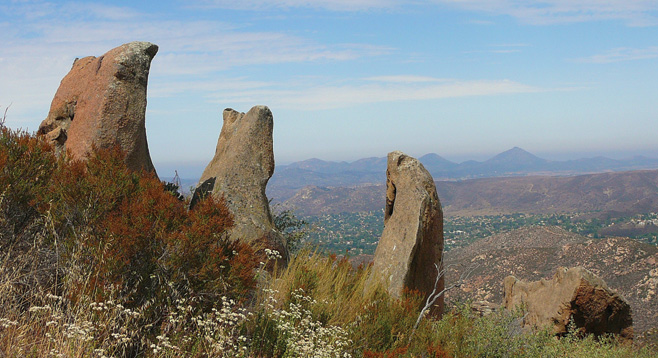
The trail continues to wind along the ridges and comes to the first of two meadows. Cross the meadow climbing up to a rock shelf to the upper meadow. The real attraction here is the unusual rock formations butting into the air. Note the great variety of lichen and moss found on the rock slabs. Lichen is a mutualistic symbiotic association of a fungus with an algae and or a cynobacterium. The fungus provides an environment through attachment to the rocks and protection from elements for its partner(s) that provide the food via carbohydrates by photosynthesis.
Reach the top of Mt. Gower either by climbing east across the granite slabs and scramble to the top of the southernmost ridge or continue following the trail for another 1.5 miles to the 2300-foot peak for another overview of San Diego Country Estates. Follow the trail back to the parking area.
Animals that may be seen in the preserve include coyote, mule deer, raccoons, foxes, and bobcats. Common birds include ravens, California thrashers, scrub jays, lesser goldfinches, and red-tailed hawks.
Best time to visit the preserve is November through April, when it is cooler for hiking. The preserve is open 8 a.m. to sunset. If hiking later in the season, pick a cloud-covered day or come early in the morning.
Distance from downtown San Diego: 40–45 miles. Allow one hour. Via I-8 and SR 67N: turn east (right) on Willow Road and then north (left) to Wildcat Canyon Road. After 12 miles, turn right on San Vicente Road and then after 1.7 miles, turn left onto Gunn Stage Road. Drive 1.9 miles to the end of the road and park. Via Ramona: turn south on 10th Street, which becomes San Vicente Road. Drive 5.5 miles and turn left on Gunn Stage Road. Drive 1.9 miles to the end of the road and park.
Hiking length: Up to 12 miles round trip if hike begins from the parking area at the end of Gunn Stage Road. Shorter distances possible.
Difficulty: Strenuous because of the distance and undulating trails. Starting elevation is about 1700 feet, and maximum elevation is about 2693. Facilities and water at the staging area only. It can be hot and dry. Carry at least a gallon of water and trail snacks. Trekking poles recommended. Trail open to equestrians, mountain bikers, and leashed dogs.