Sponsored
Sponsored
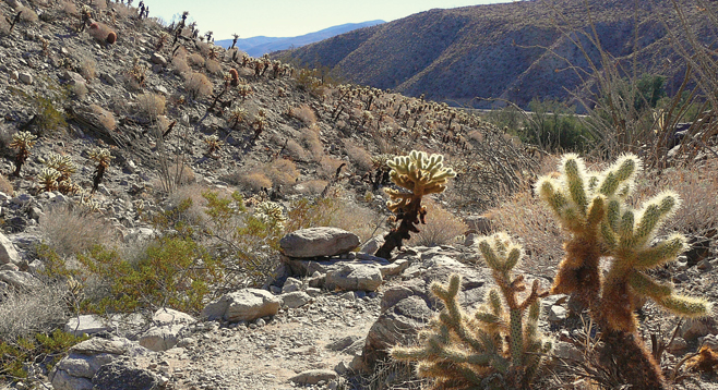
One of the easiest ways to compare the differences between the various types of cacti and to learn how plants survive on steep, rocky slopes is on the Cactus Loop Trail. A nature-trail guide, available at the trailhead, provides interpretive information at 14 numbered stops along the loop.
Cacti found on this trail include hedgehog, fishhook, Gander’s cholla, beavertail, teddy bear cholla, pencil cholla, and barrel cactus. The most notable is the teddy bear cholla, which is literally a forest of shrubs on this trail with some specimens almost six feet tall. Contrary to its name, it is not a cactus that one would cuddle. It is fiercely armed with joints that easily detach, hence its other name of “jumping cholla.” Mature specimens are surrounded with cholla balls that can easily and quickly catch a ride on hiking boots, clothing, and passing wildlife. The fallen balls are able to root and grow into a new plant. Look for small teddy bear plants surrounding mature larger plants.
Use caution when extracting cactus, as thorns easily pierce the skin. A comb and/or tweezers are recommended gear for desert hiking but are not enough for an encounter with a beavertail cactus. The beavertail is deceptive in its appearance, with its flat, rounded pads. There are no visible long thorns. Instead, it has very tiny, almost microscopic barbed bristles called glochids that can easily penetrate the skin. The best way to remove these barbed bristles is with a piece of duck tape.
One desert animal that is seemingly unaffected by cactus thorns is the desert pack rat, which gathers cholla balls around its burrows as a defense against predators. Look for burrows on this hike.
The Cactus Loop trail gradually climbs up and over a ridge. From the top of this ridge there are views out toward the Mescal Bajada — overlapping alluvial fans — to the southeast that are covered with agave (mescal). The trail also provides a close-up view of the San Felipe fault trace. One of the numbered stops overlooks a desert wash that clearly shows the work of water during flash floods that can move massive amounts of material to help form the landscape.
This trail is also a study on how perennial plants are able to survive the extremes in temperature found in the desert. Some plants have tiny leaves or even a shiny, oily coating on their leaves to reflect sunlight, like the creosote, while another will have a hairy leaf surface that provides shade when it is hot, like the brittlebush. Other plants will quickly drop their leaves if dry and grow leaves anew if they receive moisture, like the ocotillo. The barrel cactus expands to store water during dry times, and the agave has thick leaves that also store water. The spines and thorns of cacti help protect the plant from browsing animals. All of these are examples of some of the techniques plants use to survive desert heat and the lack of moisture.
Another thing to note on this hike is the rust-colored stains found on the rocks. Known as desert varnish, it is not clear as to how it has formed over thousands of years, but it is conjectured that bacteria that live on the rocks absorb manganese and iron oxide, giving the reddish hue. It is further believed that the bacteria cements tiny particles of clay to themselves to prevent drying out, also giving a brownish hue.
Canyoneers are San Diego Natural History Museum volunteers trained to lead interpretive nature walks that teach appreciation for the great outdoors. For a schedule of free public hikes, refer to the San Diego Natural History Museum website.
Distance from downtown San Diego: 81 miles. Allow 1 hour and 45 minutes of driving time. From Julian, drive east on SR-78, down Banner Grade, across Scissors Crossing to the junction with SR-3, the Yaqui Pass Road. Drive 0.3 mile to the entrance of the Tamarisk Grove Campground and park on the road. The trailhead is across the street from the entrance to the campground. Facilities available in the campground when open.
Hiking length: 0.6 mile round trip. Allow 30 minutes.
Difficulty: Easy, but steep and rocky in places. Elevation gain/loss 220 feet. Okay for children. Watch for cactus.