Sponsored
Sponsored
This is one of the most popular hiking trails in the Anza-Borrego Desert. Where else can you camp in comfort with full facilities, including hot showers, and soak in pools of geothermally heated mineral water after a vigorous hike through a beautiful canyon? Agua Caliente is a small county park tucked into the much larger Anza-Borrego Desert State Park. It is located on a spur of the very active Elsinore Fault that causes heated water to percolate to the surface in springs that dot this portion of the Tierra Blanca Mountains.
The hike described here reverses the normal designated Moonlight Trail loop that begins across from the shuffleboard courts and next to campsite #140. The reverse loop avoids the boulder-hopping and scrambling over short, dry falls in places that are found at the beginning of the designated trail. The reverse loop allows everyone to experience Moonlight Canyon while giving the option of turning back at the more challenging section.
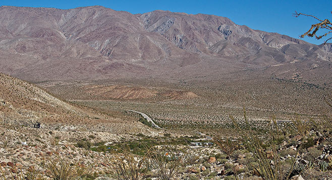
From the signed “Moonlight Trail End,” near the caravan area and campsite #63, head in a southeasterly direction across the flat, sandy desert, through tall ocotillo, burrobush, agave, creosote bush, cholla, and possibly masses of wildflowers if the timing of your visit is right. The trail turns south as it enters Moonlight Canyon. The canyon becomes progressively narrower as you proceed. After you have hiked about half a mile you come to “the Narrows,” where the canyon walls are only a few feet apart. As you go through the Narrows, note the white granite rocks for which the Tierra Blanca Mountains and Moonlight Canyon were named. This is also a wet area where year-around water permits lush vegetation to grow. Plants here include mesquite, catclaw, willows, apricot mallow, chuparosa, and desert lavender. While some of these are rather prickly, you can enjoy the scent of the desert lavender and the colorful chuparosa almost year around. In less than 0.2 mile, the canyon widens somewhat and you resume hiking over soft sand. Turn back here if you want to avoid the more challenging section of the trail.
The trail leaves Moonlight Canyon 0.85 mile from the start and proceeds up a smaller tributary canyon. If you are still in Moonlight Canyon beyond this point you will come to a large red sign that reads, “DO NOT ENTER.” If you find yourself there, you missed the turn. Back up a bit and look for the trail nearer the west side of the canyon. The trail rises more steeply in the next quarter of a mile until it reaches the top of a saddle. As you are climbing, note the numerous large barrel cactus and abundant agave. It is downhill from this point to the campground, but take care getting down the dry falls.