Sponsored
Sponsored
Mt. Woodson is one of San Diego’s favorite places for a day hike. Many people make the climb on the asphalt-paved road on the east side of the mountain off SR 67 that rises steeply to the top. Other hikers take the somewhat longer but more scenic west side trail that starts from Lake Poway. A less traveled option, presented here, is to start your ascent at the Blue Sky Reserve, adding a few more miles but giving you a chance to stroll through one of San Diego’s more scenic oak woodlands while experiencing a diversity of vegetation types on your way up. The Blue Sky Reserve, jointly managed by the California Department of Fish & Game and the City of Poway, directly connects to Poway’s extensive network of hiking trails.
This is a moderate to strenuous 11-mile round-trip hike on well-marked and maintained trails. Start hiking on the Blue Sky Reserve Trail, at the south end of the parking lot. Although this trail continues 2.4 miles to the Ramona Dam, turn south (right) 0.9 mile from the trailhead onto the Lake Poway Recreational Area trail. Much of both of these trails pass through a beautiful coast live oak forest and near a lush riparian community with mature western sycamores, black willows, and mule fat, as well as oaks. In another 0.25 mile is the Poway Wilderness Picnic Area with picnic tables, water, and toilet facilities. From there, the trail switchbacks up a coastal sage scrub-covered hillside to take you over the east side of the Lake Poway Dam and into the recreation area.
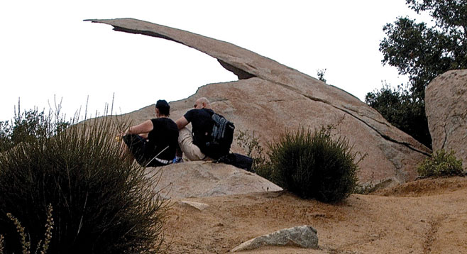
The Lake Poway Trail loops around the lake, but leave the lake when the Mt. Woodson trail branches off to the left, 0.4 mile ahead. For the first mile, the trail is a nearly straight, somewhat steep, dirt road whose saving grace is the view behind of the lake that recedes as you climb. A little over one mile from the lake is Warren Canyon–Mt. Woodson Trail junction. From this point on the trail is more interesting, extending up the chaparral-covered hillside, initially through a series of switchbacks, but then straightening out to climb up a ridge to the top of Mt. Woodson, 1.9 miles ahead. On your way are some amazing well-weathered boulders, including the famous potato chip rock. Do not forget to check out the vegetation, including big berry manzanita and several kinds of ceanothus that add interest and color to the hike. Long before reaching the top, a forest of tall metal communications towers rise from the peak and define your goal. After exploring the peak area, return the way you came.