Sponsored
Sponsored
On any given day, the main route up Cowles Mountain, the highest point in the city of San Diego, is busy. A route with less traffic and easy parking is the Mesa Trail route that may be accessed via Mesa Road in Santee or Lake Murray Boulevard on the western side of El Cajon near Grossmont College. The advantage of this route, besides being less traveled, is greater variety in the landscape, including creek crossings with riparian plants, chaparral-shaded trails, and a meadow crossing. This area of Mission Trails Regional Park is easy to stay on trail, as it is so well signed!
At the Lake Murray Boulevard trailhead, begin hiking down the old service road that is an extension of Mesa Road in Santee. After 0.57 mile, look to the west for the beginning of the Mesa Trail that is signed. Cross the small bridge over the creek and begin the hike up the mountain, noting a variety of typical chaparral plants that include laurel sumac, scrub oak, chaparral broom, chamise, California buckwheat, ceanothus, curley dock, and San Diego goldenbush. During spring, blooms of bush monkeyflower and California poppy can be seen. The trail is rocky and uneven. As you increase elevation, red-barked manzanita trees will provide shade and the odor of black sage will be in the air.
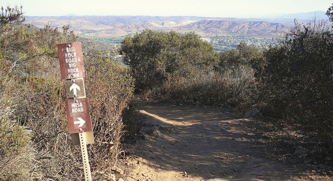
At mile 1.36 will be the signed junction of Big Rock Road that will lead down to Big Rock Park in Santee; at 890 feet, this is the high point of this hike. Big Rock Road continues up the mountain to Barker Way and the back road up to Pyle’s Peak, which is the Cowles Mountain summit, a distance of about 2.5 miles. To do the peak in this loop will add 5 miles to the overall trip.
Take the down trail and notice the great view toward SR-52 and Santee as the trail descends toward a small meadow. At mile 2.31 is a small intermittent creek crossing that may be dry during summer. Sycamores and mule fat are found here.
After crossing the creek, Big Rock Park will soon be visible where there are restrooms and water. The trail entrance to Big Rock Trail is at mile 2.46. This is the lowest elevation on the hike — 370 feet. At the trail entrance, turn right (south) and begin hiking up Mesa Road to return to your vehicle. No vehicles are allowed on the road past mile 2.91. The route will pass the entrance to Mesa Trail at mile 3.05, and a half-mile further will be the top of Lake Murray Boulevard.