Sponsored
Sponsored
The trail to the Eagle Rock formation passes by huge old live oaks and what may be San Diego’s oldest and largest sugar bush. From March to May there can be fields of wildflowers. It is also an opportunity to hike a little over a 3-mile segment of the Pacific Crest Trail (PCT), which stretches 2627 miles from Mexico to the Canadian border.
From the trailhead, follow the well-marked PCT signs south and east up Canada Verde Creek as it passes through open oak woodland with huge old coast live oaks. Notice that some of the oaks are marked as bee trees.
The creek runs strong after rains and is lined with dense riparian vegetation, including willows, alders, sycamores, snowberry, and abundant poison oak.
The trail follows the creek, but it is largely out of the creek bottom, making the hike through the woodland very easy. At intervals the oak woodland is interspersed with chaparral shrubs, including eastwood manzanita, redshank, holly leafed cherry, mountain mahogany, and golden gooseberry. The dense chaparral found here is dominated by chamise (Adenostoma fasciculatum), a plant of the rose family that was used by indigenous people for kindling and torches. Look for one of the oldest and largest sugar bush plants (Rhus ovata) that appears to be more like a tree than a shrub.
After about 1.25 miles, the trail leaves the oak woodland and begins a gradual climb up a hillside sparsely covered with chaparral. In an exceptional year this area can put on a stunning display of annual wildflowers, including goldfields, desert dandelion, baby blue eyes, cream cups, owl’s clover, ground pink, wine cup, and California poppy. As this is the west side of the San Ysidro Mountains, the display will come a little later than on the hotter, dryer east side.
After 2.0 miles, the trail goes over a gentle rise and crosses open grassland with much evidence of cattle, possibly including the cattle themselves. Here in this open rangeland are sporadic occurrences of annual wildflowers, including ground pink and blue larkspur and non-native grasses. At the peak of the season, whole hillsides may be painted blue, yellow, red, or golden with wildflowers.
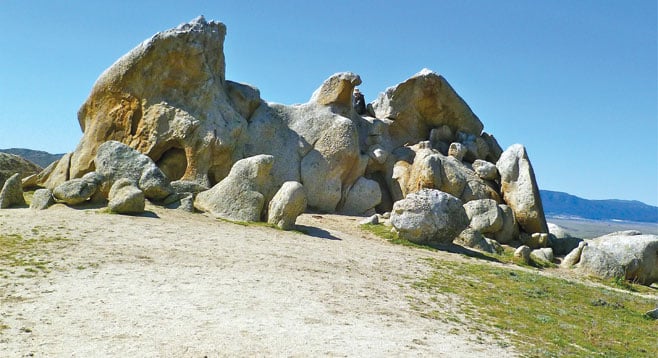
At about 3.4 miles from the start, an outcropping of boulders on the hill up ahead will become visible. Here there is a fork in the trail with the PCT going to the right. Take the spur trail to the left (east) that heads for the rocky outcrop and circles around it. Eagle Rock is among these rocks. For a startling view, walk around the backside of the outcrop about 30 to 40 feet beyond the formation before turning around to view the eagle. From this vantage point there is no doubt why it is named Eagle Rock. After viewing the eagle and having lunch or a snack, return to your car via the same route.
This trail is not suitable for the handicapped. Be sure to take plenty of water, as it can be rather warm in the meadow area where there is no shade. Remember to stay on the PCT except for the jaunt to the rock formation.
Distance from downtown San Diego: About 70 miles. Expect to drive 1 hour and 35 minutes. From
San Diego, drive to Ramona and take Hwy 78 east to Santa Ysabel. Turn left (northeast) on Hwy 79 and drive 14 miles. Park next to the fire station. The trailhead is about 10 yards south of the Warner Springs fire station on the east side of Hwy 79. Look for a gate and the Pacific Crest Trail sign. There are no facilities.
Hiking length: 6.5 miles round trip.
Difficulty: Easy to moderate, with elevation gain/loss of about 1530 feet.
Canyoneers are San Diego Natural History Museum volunteers trained to lead interpretive nature walks that teach appreciation for the great outdoors. For a schedule of free public hikes:
http://www.sdnhm.org/education/naturalists-of-all-ages/canyoneer-hikes/