Sponsored
Sponsored
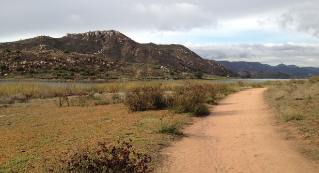
The aptly named Piedras Pintadas (“painted rocks”) trail in Escondido explores a small part of the rich San Diego County Kumeyaay Indian culture and habitat by following a well-marked trail with interpretive plaques. The trail wraps around Bernardo Bay on Lake Hodges, which is an important habitat refuge for many native and migratory animal species, especially birds.
Walking through the boulder-strewn hills that circle Lake Hodges, it’s easy to see why the native Kumeyaay peoples were inspired to use these natural canvases for the ceremonial rock art that this area is well known for today. Although the purpose of these pictographs is not entirely known, they were likely important for the spiritual or religious practices of the Kumeyaay. The Kumeyaay were a people that were deeply in tune with the land they inhabited, both spiritually and physically. Although things have changed in the 500–1000 years since the rock art was created, including the creation of Lake Hodges itself, it is still possible to explore this area and picture a much different time.
Although one can sample several of the habitat types important to the Kumeyaay on this hike, the actual pictograph site is now off limits to the public due to vandalism. However, interpretive signs along the trail provide fascinating insights into Kumeyaay culture and daily life, including information about edible and medicinal plants, use of natural resources, and the technologies they developed to survive in this harsh environment.
A large boulder that was used as a food processing center still contains depressions, or “mortars,” in which acorns and other grains were ground by a hand-held pestle. Many of the most important Kumeyaay plant species are still abundant along the trail as well.
Lake Hodges was not originally part of this Kumeyaay landscape. There was once a river before it was impounded by Lake Hodges Dam to the west. The lake has since become a crucial habitat for the endangered California gnatcatcher in addition to supporting raptors, wetland birds, and many other species. A visit in the winter months should provide great birding opportunities, as many winter residents and stop-over migrating species may be seen. A summer hike may afford more reptile sightings. Hikers should be wary of rattlesnakes that might be in the vicinity.
This 3.8 mile looping trail is just off I-15 on the south side of Lake Hodges. Depart from the southwest corner of the parking lot off West Bernardo Road, directly across the street from a large retirement complex. Pick up a map at the trailhead information center and work your way south and west, circling south of Bernardo Bay. Enjoy the wetland plants and wildlife and notice the changing vegetation as you climb a short but steep section into the coastal sage scrub of the hills overlooking the lake. After passing a small waterfall, go through a gate and work to the right to climb the scenic Ridge Loop Trail. The entire hike will take anywhere from 1–2.5 hours, depending on the number of stops for reading signs or viewing bird life.
Distance from downtown San Diego: Approximately 30 minutes. Take I-15 to the West Bernardo Dr./Pomerado Rd. exit. Head west on West Bernardo Dr. for about a half-mile and turn into the dirt parking lot on the right.
Hiking length: 3.8 miles round trip.
Difficulty: Easy; up to 200 ft. elevation change. Suitable for children.
Canyoneers are San Diego Natural History Museum volunteers trained to lead interpretive nature walks that teach appreciation for the great outdoors. For a schedule of free public hikes:
http://www.sdnhm.org/education/naturalists-of-all-ages/canyoneer-hikes/