Sponsored
Sponsored
The County of San Diego’s brand-new Flume Trail linking El Monte Park to Blossom Valley is hardly flat, as the name “flume” might imply. On the contrary, it darts relentlessly upward on a zigzagging route, gaining some 1100 feet of elevation. Another strange thing about this trail is the name of the destination, Blossom Valley. At the top end of the trail, you end up at the northern border of the unincorporated community of Blossom Valley, which happens to be the top of a ridge.
What’s the flume connection? The trail crosses, but does not follow, the remains of the century-plus-old, redwood-planked flume, or aqueduct, that once brought the waters of the Cuyamaca Mountains to Grossmont Summit (La Mesa) and farther west. Much of the flume’s 36-mile-long grade is hard to identify today, since little fill-dirt was used to maintain the flume’s uniform fall of 4 feet, 8 inches to the mile. Instead, workers employed numerous cuts, several tunnels, and more than 300 trestles. The completion and filling of El Capitan Reservoir in the 1930s put an end to the flume’s usefulness. The nine million board-feet of lumber used for the flume itself and for the trestles was scavenged a long time ago.
To get to the trailhead from Lake Jennings Road in Lakeside, drive east on El Monte Road for about four miles. On the left is a just-opened, spacious trailhead parking lot/equestrian staging area. On the right lies El Monte County Park, a beautiful picnic and recreation park set among live oaks, all below the soaring south face of El Cajon Mountain (known as El Capitan). Take your pick: park in the staging area for free or enter El Monte Park and pay a $3 day-use fee.
The Flume Trail starts by wrapping around the west boundary of El Monte County Park. It slips through a break in a chain-link fence, and then begins its relentless ascent. The trail’s nearly uniform four feet width accommodates horses and hikers.
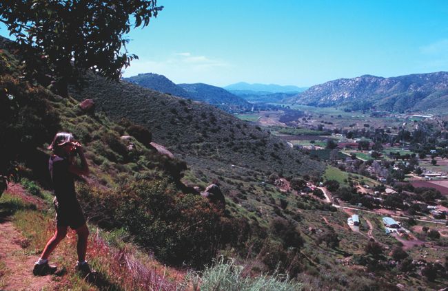
At about 0.6 mile into the hike, the trail levels out (the unrecognizable flume grade once crossed here), drops down a short series of switchbacks to avoid a parcel of private land, and then starts climbing again. You see the task ahead: put one foot after another on the clearly visible upward zigzags imprinted on the hillside to the south.
As you climb, there are jaw-dropping vistas of El Capitan rising in the east and a beautiful panorama of the agricultural El Monte Valley stretching west. On the distant hillside to the left of the valley, you’ll spot the unmistakable trace of the flume grade. Cut-and-fill construction was possible along that stretch, and the scar remains.
At nearly two miles, the trail levels, descends slightly, and you end up at the edge of Creek Hills Road in Blossom Valley, next to the common driveway serving addresses 15222 and 15234. There’s only one way back to El Monte Park: retracing your steps. On the other hand, consider having a friend drop you off at one end of the trail and later pick you up at the other end. Go up if you want intense exercise. Head down if you don’t, but at the possible expense of sore knees.
This article contains information about a publicly owned recreation or wilderness area. Trails and pathways are not necessarily marked. Conditions can change rapidly. Hikers should be properly equipped and have safety and navigational skills. The Reader and Jerry Schad assume no responsibility for any adverse experience.
East County’s Flume Trail
Earn your exercise points on the new Flume Trail out of El Monte Park.
Distance from downtown San Diego: 25 miles
Hiking length: 4 miles round trip • Difficulty: Moderately strenuous