Sponsored
Sponsored
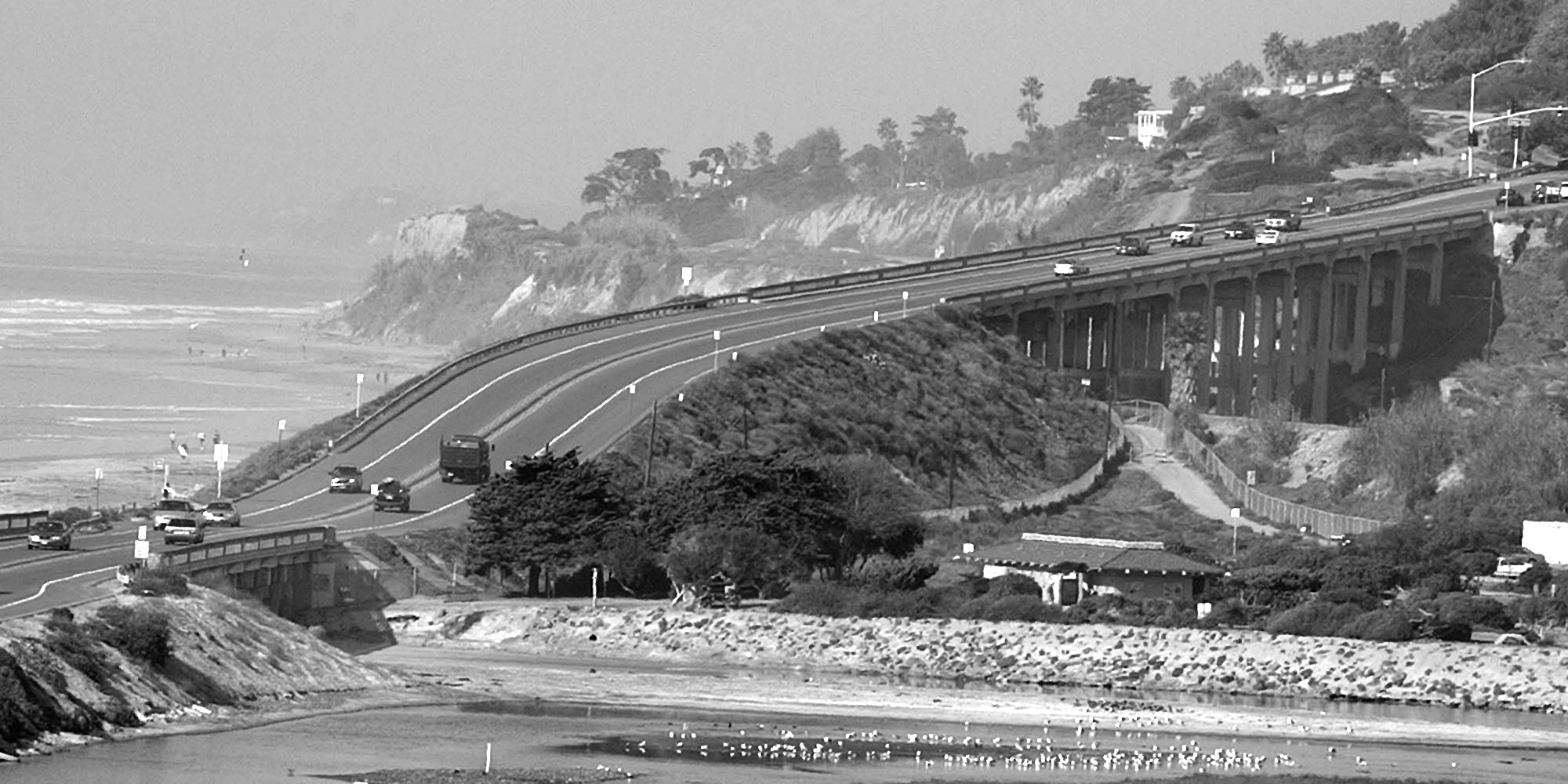
The three lanes of Torrey Pines Road between the state reserve of the same name and Del Mar crown a half-mile sand berm separating the Pacific Ocean to the west and Los Peñasquitos lagoon to the east. Near the north end of the berm, the road narrows to two lanes as it crosses a concrete bridge erected in 1932. The bridge, about 100 yards long, spans the mouth to the lagoon. From underneath, it doesn't take a structural engineer to see it needs replacing. The 72 concrete piles holding it up are heavily weathered. Constant tidal flows have cut away at the columns so that the portion below the high tide line is thinner than above. "The current bridge is in bad shape," says Kris Shackelford, a senior civil engineer with the City of San Diego's Engineering and Capital Projects department. "The sufficiency rating is 19 out of a 100 possible. And anything under 50 is in need of replacement. We need to replace it badly."
A plan to do just that is in the works. In fact, the $12.5 million project -- $10 million in federal highway funds, and $2.5 million of city money -- has been in the works for nearly a decade. In July, the California Coastal Commission approved the city's plans. After pending approvals from the federal National Environmental Protection Agency and the state of California Environmental Quality Agency -- better known as NEPA and CEQA -- the city council will vote on the project, which is not without its critics. One is Diana Bergen, president of a local preservation group called the Torrey Pines Association. Standing in the North Torrey Pines Beach parking lot, just east of the bridge in question, Bergen points to the decaying span. "The bridge needs rebuilding. There's no question about that. The bridge is in really bad shape."
What Bergen does question is the city's design, which calls for three lanes instead of two. The plan dates back over a decade, to a time when the City of San Diego owned half of the higher bridge, a quarter mile to the north. The City of Del Mar owned the other half. Crossing over the railroad tracks, the "north bridge" — or "high bridge," as it is variously known by locals — is now owned solely by the City of Del Mar.
"When the City [of San Diego] started in the early 1990s to redo these bridges," Bergen explains, "they had in mind that they would make these into three- or four-lane-wide bridges. It was part of their whole plan regarding Carmel Valley and the 56. The City of Del Mar didn't like that idea because they have been fighting to have the main road through their little town be just a two-lane road. They even just recently redid the bridge on the north side of their town, and it's a two-lane road. They used Laguna as an example, because Laguna just kept widening their road until they had a four-lane highway going through their little town. I don't know all the details, but the City of San Diego, in an effort headed by [former councilman] Harry Mathis, said, 'Del Mar, give us a dollar. You now own the North Bridge, and you can take care of the fiscal responsibility for that bridge.' Del Mar accepted, and they proceeded to have it named a historical bridge."
Robert Gilleskie serves as chairman of the Torrey Pines Community Planning Board. "We oppose widening the bridge because there is no need to do it," he says. "The city adamantly wants to stick with an old plan which was made obsolete several years ago when the City of Del Mar decided to keep their bridge at two lanes. Either because of hubris or because of some silly reason that I don't know of, they want to maintain the idea of making it three lanes wide, and we are going to have a much wider bridge there than is necessary."
Gilleskie, who is an engineer, agrees that the bridge must be replaced. "For two reasons," he explains, "one, for seismic requirements, and two, to improve flushing of the lagoon. But either design is the same with regard to tidal flushing. In either case -- three-lane or two-lane -- they go from 72 supports down to 4." The high number of supports on the current bridge causes sand to accumulate and block the lagoon opening. "But there is as much as an acre of extra concrete," Gilleskie continues, "in their three-lane design. That's an acre of unnecessary concrete in a well-protected preserve. For the coastal commission to say that is okay is, I think, scandalous. It is a terrible thing."
Gilleskie and Bergen attended the July coastal commission meeting in Huntington Beach, where the city's plan to build a wider bridge was approved. "Frankly, that was a whitewash," Gilleskie says. "They had their minds made up before we even got in there. They said [their design] was going to improve tidal flushing in the lagoon. But our plan would improve it just as much. As I said before, it is irrelevant whether the bridge is two lanes or three lanes wide, as far as the flushing of the lagoon goes. The understructure would be identical. So they basically played with words to make it sound like they were doing something good for the environment, when in fact they were allowing the City of San Diego to build a bridge much wider than they should."
Gilleskie adds another complaint, "[The City] told us that it would be $3 million more expensive to build a two-lane bridge than a three-lane bridge. Does that make sense to you?"
Shackelford believes it does make sense. "When the project was first conceived in 1990," she explains, "it was a plan for both the south bridge as well as the north bridge to be widened, for that whole corridor to be widened. So the bridge was designed for the three lanes. [To redesign for two lanes] would be very costly, and it's money that we don't have. It would also set the timing of the process back. We would have to do both the CEQA and the NEPA environmental documents again, because the two-lane bridge would require a totally different document. More important is [the question of] how to move the existing traffic without disrupting it. And part of the beauty of doing a three-lane bridge is that we are going to be doing stage construction. So we are going to move the traffic to one side and demo part of the bridge and then build the other side. So there will be no disruption in traffic during construction at all. And we won't have to build temporary bridges, which would encroach into the lagoon or into the beach and which require totally different environmental documents."
Shackelford continues her explanation. "And building a three-lane bridge is what we have to do in order to keep the traffic moving [in the future]. It backs up every day; everybody knows that. So the bridge was designed for the three lanes, and that is what we are pursuing."
Bob Lewis, former chairman of the Torrey Pines Planning Commission, doesn't buy the traffic-flow arguments. "Traffic circulation will not improve," he says. "The choke point will still be there because Del Mar has made the statement, 'We will not widen our bridge.' "
Shackelford concedes that Del Mar has no plans to widen the north bridge. "They had it named a historical landmark," she says, "and their plan, when I last spoke to them, was to retrofit the existing bridge."
Owens, Gilleskie, and Bergen all speculate that the City of San Diego is building the wider bridge in the belief that Del Mar will someday relent and widen its bridge. Shackelford declines to address such speculation directly but offers, "This bridge that we are building will have a life span of 75 to 100 years."