Here's something you might be interested in.
Ask a Hipster — Advice you didn't know you needed
Big Screen — Movie commentary
Blurt — Music's inside track
Booze News — San Diego spirits
Classical Music — Immortal beauty
Classifieds — Free and easy
Cover Stories — Front-page features
Drinks All Around — Bartenders' drink recipes
Excerpts — Literary and spiritual excerpts
Feast! — Food & drink reviews
Feature Stories — Local news & stories
Fishing Report — What’s getting hooked from ship and shore
From the Archives — Spotlight on the past
Golden Dreams — Talk of the town
The Gonzo Report — Making the musical scene, or at least reporting from it
Letters — Our inbox
Movies@Home — Local movie buffs share favorites
Movie Reviews — Our critics' picks and pans
Musician Interviews — Up close with local artists
Neighborhood News from Stringers — Hyperlocal news
News Ticker — News & politics
Obermeyer — San Diego politics illustrated
Outdoors — Weekly changes in flora and fauna
Overheard in San Diego — Eavesdropping illustrated
Poetry — The old and the new
Reader Travel — Travel section built by travelers
Reading — The hunt for intellectuals
Roam-O-Rama — SoCal's best hiking/biking trails
San Diego Beer — Inside San Diego suds
SD on the QT — Almost factual news
Sheep and Goats — Places of worship
Special Issues — The best of
Street Style — San Diego streets have style
Surf Diego — Real stories from those braving the waves
Theater — On stage in San Diego this week
Tin Fork — Silver spoon alternative
Under the Radar — Matt Potter's undercover work
Unforgettable — Long-ago San Diego
Unreal Estate — San Diego's priciest pads
Your Week — Daily event picks
You Are Here, Or So
Often I get confused looks, even from longtime San Diego residents, when they ask where I live. "South Park...heh heh...they killed Kenny!" Ha. "No really, where is that?"
"Near downtown, on the other side of the park," I say. Or, "South of North Park."
"Oh yeah? Huh."
I air-draw Balboa Park as an upright rectangle, swirl around the area beyond the bottom-right corner. "Down here by the golf course. You ever play Balboa 9?"
These descriptions provide a general idea, but because this hood isn't really in between or on the way to anything, you don't stumble upon it and lots of folks don't know where the hell "South Park" is, other than late-night Cartoonland. Which is just fine, thanks. Don't bother. The neighborhood sucks. No services, rinky-dink old houses, bad cell reception, diverse ethnic mix (gasp), you wouldn't like it. Seriously.
But for the diligent among thee, where is there, exactly? South Park Neighbors provides a historical description:
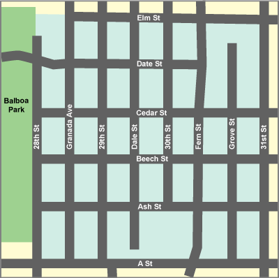
"South Park is one of downtown San Diego's first suburbs. A subdivision called the South Park Addition was registered on May 17, 1870. Its original boundaries were a rectangle formed by Park St. (now 28th St.) on the west, A St. on the south, a canyon running along the line of 32nd St. on the east and an arbitrary line between Cedar and Date streets on the north."
If we impose those boundaries on the current grid, South Park OG Rectangle looked something like this:

The South Park That Time Forgot. This original subdivision leaves out a lot of what is definitely South Parkian. Hmm. Maybe SOHO (Save Our Heritage Organisation) can give us a little guidance:
Whoa. We lost ground to the East but gained a block and a half to the North. How did...a-ha. SOHO isn't describing a neighborhood but a historic district:
"The district is called "South Park," and is roughly North of A Street, South of Elm Street, West of 31st Street, and East of Balboa Park. ... A survey conducted in 1996 of the area buildings proposed a historic district boundary that lies within the original South Park subdivision map and also includes part of the Seaman and Choate subdivision map. These maps adjoin in the middle of several blocks."
Cool. But where's the rest? Help me, City of San Diego. What does the actual city government consider the neighborhood to be?

That's helpful, sort of. Balboa Park to the West and A street to the South, ok. And...a panhandle to the Southeast, a squiggly line to the East, and somewhere about halfway up the park to the North. Clearly not an exact science. We're getting closer but still don't have a definitive map.
Tune in tomorrow, or so, when I manually draw what South Park seems to be. Consider thyself Whetted.
Here's something you might be interested in.
Previous article
Blue Whales: Return of the Giants, North Park Salsa Fest, Lime Cordiale
Events April 19-April 20, 2024
You Are Here, Or So
Often I get confused looks, even from longtime San Diego residents, when they ask where I live. "South Park...heh heh...they killed Kenny!" Ha. "No really, where is that?"
"Near downtown, on the other side of the park," I say. Or, "South of North Park."
"Oh yeah? Huh."
I air-draw Balboa Park as an upright rectangle, swirl around the area beyond the bottom-right corner. "Down here by the golf course. You ever play Balboa 9?"
These descriptions provide a general idea, but because this hood isn't really in between or on the way to anything, you don't stumble upon it and lots of folks don't know where the hell "South Park" is, other than late-night Cartoonland. Which is just fine, thanks. Don't bother. The neighborhood sucks. No services, rinky-dink old houses, bad cell reception, diverse ethnic mix (gasp), you wouldn't like it. Seriously.
But for the diligent among thee, where is there, exactly? South Park Neighbors provides a historical description:
"South Park is one of downtown San Diego's first suburbs. A subdivision called the South Park Addition was registered on May 17, 1870. Its original boundaries were a rectangle formed by Park St. (now 28th St.) on the west, A St. on the south, a canyon running along the line of 32nd St. on the east and an arbitrary line between Cedar and Date streets on the north."
If we impose those boundaries on the current grid, South Park OG Rectangle looked something like this:
The South Park That Time Forgot. This original subdivision leaves out a lot of what is definitely South Parkian. Hmm. Maybe SOHO (Save Our Heritage Organisation) can give us a little guidance:
Whoa. We lost ground to the East but gained a block and a half to the North. How did...a-ha. SOHO isn't describing a neighborhood but a historic district:
"The district is called "South Park," and is roughly North of A Street, South of Elm Street, West of 31st Street, and East of Balboa Park. ... A survey conducted in 1996 of the area buildings proposed a historic district boundary that lies within the original South Park subdivision map and also includes part of the Seaman and Choate subdivision map. These maps adjoin in the middle of several blocks."
Cool. But where's the rest? Help me, City of San Diego. What does the actual city government consider the neighborhood to be?
That's helpful, sort of. Balboa Park to the West and A street to the South, ok. And...a panhandle to the Southeast, a squiggly line to the East, and somewhere about halfway up the park to the North. Clearly not an exact science. We're getting closer but still don't have a definitive map.
Tune in tomorrow, or so, when I manually draw what South Park seems to be. Consider thyself Whetted.
Sponsored