Here's something you might be interested in.
Ask a Hipster — Advice you didn't know you needed
Big Screen — Movie commentary
Blurt — Music's inside track
Booze News — San Diego spirits
Classical Music — Immortal beauty
Classifieds — Free and easy
Cover Stories — Front-page features
Drinks All Around — Bartenders' drink recipes
Excerpts — Literary and spiritual excerpts
Feast! — Food & drink reviews
Feature Stories — Local news & stories
Fishing Report — What’s getting hooked from ship and shore
From the Archives — Spotlight on the past
Golden Dreams — Talk of the town
The Gonzo Report — Making the musical scene, or at least reporting from it
Letters — Our inbox
Movies@Home — Local movie buffs share favorites
Movie Reviews — Our critics' picks and pans
Musician Interviews — Up close with local artists
Neighborhood News from Stringers — Hyperlocal news
News Ticker — News & politics
Obermeyer — San Diego politics illustrated
Outdoors — Weekly changes in flora and fauna
Overheard in San Diego — Eavesdropping illustrated
Poetry — The old and the new
Reader Travel — Travel section built by travelers
Reading — The hunt for intellectuals
Roam-O-Rama — SoCal's best hiking/biking trails
San Diego Beer — Inside San Diego suds
SD on the QT — Almost factual news
Sheep and Goats — Places of worship
Special Issues — The best of
Street Style — San Diego streets have style
Surf Diego — Real stories from those braving the waves
Theater — On stage in San Diego this week
Tin Fork — Silver spoon alternative
Under the Radar — Matt Potter's undercover work
Unforgettable — Long-ago San Diego
Unreal Estate — San Diego's priciest pads
Your Week — Daily event picks
Enjoy lunch at Agua Caliente Creek on the Pacific Crest Trail
Take this hike for Lake Henshaw views and a wilderness experience
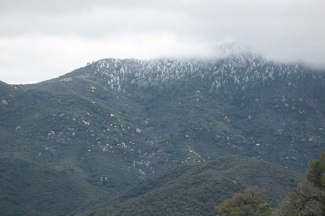
Hot Springs Mountain looms over the landscape
The Pacific Crest Trail (PCT) is a well-traveled 2,650-mile trail from the Mexican border to the Canadian border. Along this trail are many day-hike or overnight backpacking possibilities. Here in San Diego County, we have 133 miles of the trail. Along this section of the trail, you can experience untouched wilderness, with Hot Springs Mountain looming above. This area is home to mountain lions, bobcats, deer, and smaller mammals and reptiles, although you will most likely not see them. In the warmer months, rattlesnakes may be seen. The sky is home to hawks, California scrub-jays, and more.
From the parking area, walk through the gate and up the abandoned road for 0.4 mile until you reach the PCT and follow the trail to your right (south). The road will gradually turn into a trail. At 1.5 miles, there is a junction with a signed trail to water. Hike to the right and continue uphill; do not descend unless you need water or want to explore. As you hike, the views of Lake Henshaw and the expansive valley become more and more picturesque. The trail circles around a 5,000-foot peak where Volcan Mountain and Palomar Mountain come in and out of view as you continue on the trail, winding your way around ravines and, in rainy years, trickling streams.
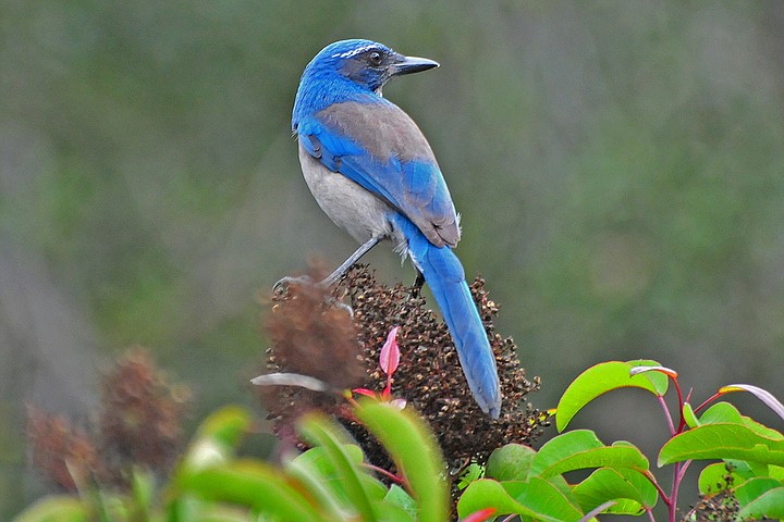
Look for California scrub-jays near oak trees
As you reach a saddle, there is an obvious rocky peaklet on your left and a side use trail where it is pleasant to stop for a snack and enjoy the views. Continue to climb around another ravine and around another tall peak. The intimidating north slope of Hot Springs Mountain, San Diego County’s highest peak at 6,533 feet, comes into view. The summit can be enshrouded in clouds with trees below sometimes encapsulated in ice.
Continue along the PCT and enjoy views of the valley below. There are no signs of civilization; it is just you and the trail. At approximately 3 miles, the trail descends to meet Agua Caliente Creek. Look for a grassy area along the seasonal stream to enjoy your lunch before continuing on.
The tall trees through which the trail passes include Coulter pine, California black oaks, and coast live oaks. Acorns from the oaks were a favorite food of Native Americans who had competition for the acorns from a variety of mammals, insects, and birds. Acorn woodpeckers (Melanerpes formicivorus) collected and stored their acorns for later use in granary trees in which thousands of holes were drilled. Acorns were shoved into the drilled holes for storage and later consumption. California scrub-jays (Aphelocoma californica) also collected and stored acorns, but instead of storing the acorns in drilled holes in trees, they buried them for later use. This was also a means of seed dispersal for oaks, as the jays sometimes did not retrieve them.
The red-barked shrubs seen on the trail are manzanita. The genus name of the manzanita (Arctostaphylos) contains the Greek name for bear (arktos). “Staphylos” means bunch of grapes, which manzanita berries resemble. Another name for manzanita is bearberries, referring to the fact that this is a favorite food of both the brown and black bears that once roamed this area. Another common shrub seen in this area is ceanothus.
After 7.5 miles, you reach Hwy. 79, where you will turn right and walk a short distance to the car you parked here. Drive back up Indian Flats Road to retrieve your other vehicle.
The best time of the year to do this hike is in spring when the wildflowers and manzanita are blooming and temperatures are cooler.
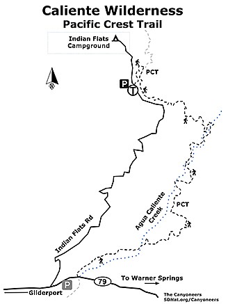
Caliente Wilderness map
CALIENTE WILDERNESS — Pacific Crest Trail
Take this hike for Lake Henshaw views and a wilderness experience.
Driving directions: (Warner Springs) The hike as described requires 2 cars. From Hwy. 79 in Warner Springs, drive north to just past mile marker 36.5 and park one car in the open area to the left. Continue in your other vehicle north for another 0.25 mile until you reach the paved Indian Flats Road on the right. A USFS signboard for Indian Flats Campground marks the start of this road, which is also called Lost Creek Road or Lost Valley Road on various maps. If you reach the Warner Springs Glider Port, you have gone too far. Continue 4.5 miles as this road winds its way through chaparral and views of the valley below, and then park (and display your National Forest Adventure Pass) in the parking area on the right. Hiking length: 7.5 miles as a one-way through hike. Difficulty: Moderately strenuous. Elevation gain up to 1,700 feet. Trekking poles recommended. Dogs and horses allowed. Suitable for backpacking. No facilities.
Here's something you might be interested in.
Enjoy lunch at Agua Caliente Creek on the Pacific Crest Trail
Take this hike for Lake Henshaw views and a wilderness experience
Enjoy lunch at Agua Caliente Creek on the Pacific Crest Trail
Take this hike for Lake Henshaw views and a wilderness experience
Hot Springs Mountain looms over the landscape
The Pacific Crest Trail (PCT) is a well-traveled 2,650-mile trail from the Mexican border to the Canadian border. Along this trail are many day-hike or overnight backpacking possibilities. Here in San Diego County, we have 133 miles of the trail. Along this section of the trail, you can experience untouched wilderness, with Hot Springs Mountain looming above. This area is home to mountain lions, bobcats, deer, and smaller mammals and reptiles, although you will most likely not see them. In the warmer months, rattlesnakes may be seen. The sky is home to hawks, California scrub-jays, and more.
From the parking area, walk through the gate and up the abandoned road for 0.4 mile until you reach the PCT and follow the trail to your right (south). The road will gradually turn into a trail. At 1.5 miles, there is a junction with a signed trail to water. Hike to the right and continue uphill; do not descend unless you need water or want to explore. As you hike, the views of Lake Henshaw and the expansive valley become more and more picturesque. The trail circles around a 5,000-foot peak where Volcan Mountain and Palomar Mountain come in and out of view as you continue on the trail, winding your way around ravines and, in rainy years, trickling streams.
Look for California scrub-jays near oak trees
As you reach a saddle, there is an obvious rocky peaklet on your left and a side use trail where it is pleasant to stop for a snack and enjoy the views. Continue to climb around another ravine and around another tall peak. The intimidating north slope of Hot Springs Mountain, San Diego County’s highest peak at 6,533 feet, comes into view. The summit can be enshrouded in clouds with trees below sometimes encapsulated in ice.
Continue along the PCT and enjoy views of the valley below. There are no signs of civilization; it is just you and the trail. At approximately 3 miles, the trail descends to meet Agua Caliente Creek. Look for a grassy area along the seasonal stream to enjoy your lunch before continuing on.
The tall trees through which the trail passes include Coulter pine, California black oaks, and coast live oaks. Acorns from the oaks were a favorite food of Native Americans who had competition for the acorns from a variety of mammals, insects, and birds. Acorn woodpeckers (Melanerpes formicivorus) collected and stored their acorns for later use in granary trees in which thousands of holes were drilled. Acorns were shoved into the drilled holes for storage and later consumption. California scrub-jays (Aphelocoma californica) also collected and stored acorns, but instead of storing the acorns in drilled holes in trees, they buried them for later use. This was also a means of seed dispersal for oaks, as the jays sometimes did not retrieve them.
The red-barked shrubs seen on the trail are manzanita. The genus name of the manzanita (Arctostaphylos) contains the Greek name for bear (arktos). “Staphylos” means bunch of grapes, which manzanita berries resemble. Another name for manzanita is bearberries, referring to the fact that this is a favorite food of both the brown and black bears that once roamed this area. Another common shrub seen in this area is ceanothus.
After 7.5 miles, you reach Hwy. 79, where you will turn right and walk a short distance to the car you parked here. Drive back up Indian Flats Road to retrieve your other vehicle.
The best time of the year to do this hike is in spring when the wildflowers and manzanita are blooming and temperatures are cooler.
Caliente Wilderness map
CALIENTE WILDERNESS — Pacific Crest Trail
Take this hike for Lake Henshaw views and a wilderness experience.
Driving directions: (Warner Springs) The hike as described requires 2 cars. From Hwy. 79 in Warner Springs, drive north to just past mile marker 36.5 and park one car in the open area to the left. Continue in your other vehicle north for another 0.25 mile until you reach the paved Indian Flats Road on the right. A USFS signboard for Indian Flats Campground marks the start of this road, which is also called Lost Creek Road or Lost Valley Road on various maps. If you reach the Warner Springs Glider Port, you have gone too far. Continue 4.5 miles as this road winds its way through chaparral and views of the valley below, and then park (and display your National Forest Adventure Pass) in the parking area on the right. Hiking length: 7.5 miles as a one-way through hike. Difficulty: Moderately strenuous. Elevation gain up to 1,700 feet. Trekking poles recommended. Dogs and horses allowed. Suitable for backpacking. No facilities.
CommentsPuremelda
This comment was removed by the site staff for violation of the usage agreement.
Aug. 15, 2019