Here's something you might be interested in.
Ask a Hipster — Advice you didn't know you needed
Big Screen — Movie commentary
Blurt — Music's inside track
Booze News — San Diego spirits
Classical Music — Immortal beauty
Classifieds — Free and easy
Cover Stories — Front-page features
Drinks All Around — Bartenders' drink recipes
Excerpts — Literary and spiritual excerpts
Feast! — Food & drink reviews
Feature Stories — Local news & stories
Fishing Report — What’s getting hooked from ship and shore
From the Archives — Spotlight on the past
Golden Dreams — Talk of the town
The Gonzo Report — Making the musical scene, or at least reporting from it
Letters — Our inbox
Movies@Home — Local movie buffs share favorites
Movie Reviews — Our critics' picks and pans
Musician Interviews — Up close with local artists
Neighborhood News from Stringers — Hyperlocal news
News Ticker — News & politics
Obermeyer — San Diego politics illustrated
Outdoors — Weekly changes in flora and fauna
Overheard in San Diego — Eavesdropping illustrated
Poetry — The old and the new
Reader Travel — Travel section built by travelers
Reading — The hunt for intellectuals
Roam-O-Rama — SoCal's best hiking/biking trails
San Diego Beer — Inside San Diego suds
SD on the QT — Almost factual news
Sheep and Goats — Places of worship
Special Issues — The best of
Street Style — San Diego streets have style
Surf Diego — Real stories from those braving the waves
Theater — On stage in San Diego this week
Tin Fork — Silver spoon alternative
Under the Radar — Matt Potter's undercover work
Unforgettable — Long-ago San Diego
Unreal Estate — San Diego's priciest pads
Your Week — Daily event picks
Lightning Ridge Trail: find Horse Heaven Group Campground off Laguna Mountain
Despite the name, this is not a horse camp.
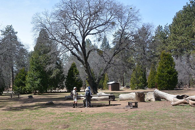
Horse Haven Campground is a good place to relax
Lightning Ridge Trail is accessible and enjoyable during all seasons, but especially beautiful in the spring and summer, when flowers and shrubs are blooming. This is a good time to hike this trail, especially with the rain that we have had this year. Particularly delightful are the ceanothus, manzanita, and chokecherry. Pine, cedar, and oak trees shade the trail as it winds upwards through the forest.
The trail is a little uneven where it is covered with small rocks; otherwise, the ground is soft forest debris. About a half mile up the road from the trailhead, you will see the trail where it crosses the rocky road. Turn to the right and take the small trail up the gently-sloping hillside. Be aware of your surroundings and watch for snakes.
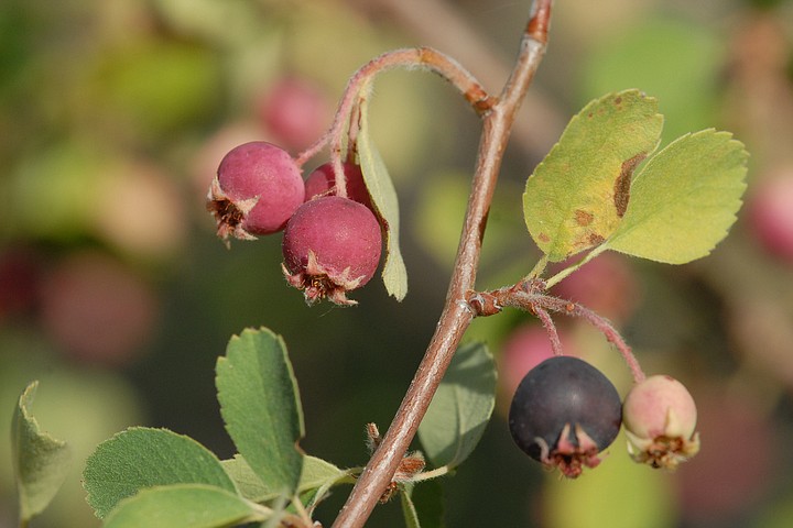
Chokecherry berries were harvested by the Kumeyaay
From this beautiful narrow trail, you will begin to get glimpses of the adjacent hillside and of the mountains in the distance. As you climb, you will notice that there are fewer trees but more shrubs and flowers, such as lupine, sunflowers, and mallow. You will know that you have reached the top of the ridge when you see the very large water tank. This is the Chula Vista Reservoir, which is the water source for that city.
From the top of the ridge, you can enjoy wonderful views of the surrounding peaks, the Laguna Meadows and the desert to the east. On the way down, you will have views of the Little Laguna Meadow and the Laguna Campground. When you reach the rocky road that you left when you reached the trail on your way up, you have a choice of either going back the same way or staying on the trail and enjoying a visit to three small group camp sites, called Lupine, Hollyhock and Buttercup, which are part of Horse Heaven Group Campground. Despite the name, this is not a horse camp. The Cleveland National Forest campsites have vault toilets, water, and campfire circles. It is designed for groups of 40, 70, or 100 people who want to stay at the sites, which are surrounded by a pine forest.
In this setting, one could imagine native peoples sitting in groups under the trees preparing food: the Kumeyaay and their ancestors traveled through the Laguna Mountains on their annual journey from the ocean to the desert and back, and there are many pre-historic archaeological sites and artifacts throughout the Laguna Mountains: grinding rocks, pottery shards, and flakes. Remember, all artifacts are legally protected—you must leave them where you find them. The Native Americans were able to feed and clothe themselves using only the plants, animals, and rocks around them.
Major food crops harvested by the Kumeyaay in years past in this area included acorns from oaks and pine nuts from pine trees. They also harvested manzanita berries, chokecherries, and the corms of wild hyacinth/blue dicks/school bells (Dichelostemma capitatum).
Once a year, the Laguna Mountain Volunteer Association presents the history of the peoples of Mt. Laguna, both the original peoples and those who arrived more recently. If you participate in one of the presentations about the Kumeyaay people, you will discover why these hunter-gatherers called these mountains a land of plenty.
By following the loop around these three group camp sites, you will find yourself back on the rocky road that you left earlier. If you follow this road east, you will find your way back to the highway and the parking area. On the way down from the mountain, you might wish to stop for a snack or ice cream at the Laguna General Store, which is just past the Ranger Station.
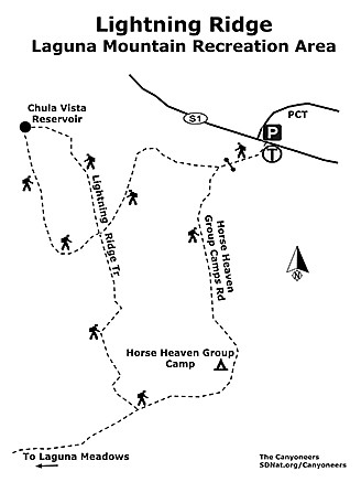
Lightning Ridge map
LIGHTNING RIDGE—LAGUNA MOUNTAIN RECREATION AREA
Enjoy amazing views of the mountains and desert.
- Driving directions: From I-8 E, exit on the Sunrise Highway (S-1). Turn left and go to mile 24.7. Park in the small parking area (space for about 8 cars) on the east side of the highway; it is opposite the road leading to Horse Heaven Group Camps. An Adventure Pass is required. Cross the highway and take the Horse Heaven Group Camps road. About an 1/8th of a mile from the highway and a little beyond the locked gate, there is a spur to the right. This is the beginning of the Lightning Ridge Trail. Hiking length: 2 miles, loop trail. Allow 1.5 hours. Hikers only; no dogs. Difficulty: Elevation at trailhead 5500 feet. Elevation gain of 200 feet. No facilities.
Here's something you might be interested in.
Lightning Ridge Trail: find Horse Heaven Group Campground off Laguna Mountain
Despite the name, this is not a horse camp.
Lightning Ridge Trail: find Horse Heaven Group Campground off Laguna Mountain
Despite the name, this is not a horse camp.
Horse Haven Campground is a good place to relax
Lightning Ridge Trail is accessible and enjoyable during all seasons, but especially beautiful in the spring and summer, when flowers and shrubs are blooming. This is a good time to hike this trail, especially with the rain that we have had this year. Particularly delightful are the ceanothus, manzanita, and chokecherry. Pine, cedar, and oak trees shade the trail as it winds upwards through the forest.
The trail is a little uneven where it is covered with small rocks; otherwise, the ground is soft forest debris. About a half mile up the road from the trailhead, you will see the trail where it crosses the rocky road. Turn to the right and take the small trail up the gently-sloping hillside. Be aware of your surroundings and watch for snakes.
Chokecherry berries were harvested by the Kumeyaay
From this beautiful narrow trail, you will begin to get glimpses of the adjacent hillside and of the mountains in the distance. As you climb, you will notice that there are fewer trees but more shrubs and flowers, such as lupine, sunflowers, and mallow. You will know that you have reached the top of the ridge when you see the very large water tank. This is the Chula Vista Reservoir, which is the water source for that city.
From the top of the ridge, you can enjoy wonderful views of the surrounding peaks, the Laguna Meadows and the desert to the east. On the way down, you will have views of the Little Laguna Meadow and the Laguna Campground. When you reach the rocky road that you left when you reached the trail on your way up, you have a choice of either going back the same way or staying on the trail and enjoying a visit to three small group camp sites, called Lupine, Hollyhock and Buttercup, which are part of Horse Heaven Group Campground. Despite the name, this is not a horse camp. The Cleveland National Forest campsites have vault toilets, water, and campfire circles. It is designed for groups of 40, 70, or 100 people who want to stay at the sites, which are surrounded by a pine forest.
In this setting, one could imagine native peoples sitting in groups under the trees preparing food: the Kumeyaay and their ancestors traveled through the Laguna Mountains on their annual journey from the ocean to the desert and back, and there are many pre-historic archaeological sites and artifacts throughout the Laguna Mountains: grinding rocks, pottery shards, and flakes. Remember, all artifacts are legally protected—you must leave them where you find them. The Native Americans were able to feed and clothe themselves using only the plants, animals, and rocks around them.
Major food crops harvested by the Kumeyaay in years past in this area included acorns from oaks and pine nuts from pine trees. They also harvested manzanita berries, chokecherries, and the corms of wild hyacinth/blue dicks/school bells (Dichelostemma capitatum).
Once a year, the Laguna Mountain Volunteer Association presents the history of the peoples of Mt. Laguna, both the original peoples and those who arrived more recently. If you participate in one of the presentations about the Kumeyaay people, you will discover why these hunter-gatherers called these mountains a land of plenty.
By following the loop around these three group camp sites, you will find yourself back on the rocky road that you left earlier. If you follow this road east, you will find your way back to the highway and the parking area. On the way down from the mountain, you might wish to stop for a snack or ice cream at the Laguna General Store, which is just past the Ranger Station.
Lightning Ridge map
LIGHTNING RIDGE—LAGUNA MOUNTAIN RECREATION AREA
Enjoy amazing views of the mountains and desert.
- Driving directions: From I-8 E, exit on the Sunrise Highway (S-1). Turn left and go to mile 24.7. Park in the small parking area (space for about 8 cars) on the east side of the highway; it is opposite the road leading to Horse Heaven Group Camps. An Adventure Pass is required. Cross the highway and take the Horse Heaven Group Camps road. About an 1/8th of a mile from the highway and a little beyond the locked gate, there is a spur to the right. This is the beginning of the Lightning Ridge Trail. Hiking length: 2 miles, loop trail. Allow 1.5 hours. Hikers only; no dogs. Difficulty: Elevation at trailhead 5500 feet. Elevation gain of 200 feet. No facilities.