Here's something you might be interested in.
Ask a Hipster — Advice you didn't know you needed
Big Screen — Movie commentary
Blurt — Music's inside track
Booze News — San Diego spirits
Classical Music — Immortal beauty
Classifieds — Free and easy
Cover Stories — Front-page features
Drinks All Around — Bartenders' drink recipes
Excerpts — Literary and spiritual excerpts
Feast! — Food & drink reviews
Feature Stories — Local news & stories
Fishing Report — What’s getting hooked from ship and shore
From the Archives — Spotlight on the past
Golden Dreams — Talk of the town
The Gonzo Report — Making the musical scene, or at least reporting from it
Letters — Our inbox
Movies@Home — Local movie buffs share favorites
Movie Reviews — Our critics' picks and pans
Musician Interviews — Up close with local artists
Neighborhood News from Stringers — Hyperlocal news
News Ticker — News & politics
Obermeyer — San Diego politics illustrated
Outdoors — Weekly changes in flora and fauna
Overheard in San Diego — Eavesdropping illustrated
Poetry — The old and the new
Reader Travel — Travel section built by travelers
Reading — The hunt for intellectuals
Roam-O-Rama — SoCal's best hiking/biking trails
San Diego Beer — Inside San Diego suds
SD on the QT — Almost factual news
Sheep and Goats — Places of worship
Special Issues — The best of
Street Style — San Diego streets have style
Surf Diego — Real stories from those braving the waves
Theater — On stage in San Diego this week
Tin Fork — Silver spoon alternative
Under the Radar — Matt Potter's undercover work
Unforgettable — Long-ago San Diego
Unreal Estate — San Diego's priciest pads
Your Week — Daily event picks
Chollas Creek: threading City Heights, Encanto, Oak Park and other communities
Enjoy a creekside walk in urban San Diego.
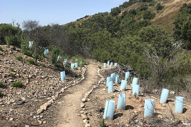
The blue cones in a restoration area are used to protect the newly-planted native plants along a rock-lined path
Chollas Creek runs through urban San Diego and is part of the Pueblo Watershed, running 32 miles from its headwaters in La Mesa and Lemon Grove to where it drains into San Diego Bay in Barrio Logan. The creek has four branches from its headwaters and runs through communities such as City Heights, Encanto, and Oak Park. The creek was a significant settlement for the Kumeyaay and provides multiple benefits to the region. Many nonprofits and organizations, including Groundwork San Diego-Chollas Creek and San Diego Canyonlands, have been working hard to restore and clean up the creek, improving trails and habitat.
This section of Chollas Creek runs through the community of Oak Park and is managed by the City of San Diego. There are trailheads at each end of this route, but the starting point for this hike is Euclid Avenue, taking the southern portion of the route, returning to the starting place, and then taking the northern portion of the route. Going south from Euclid Avenue is about a 1.75 mile out-and-back loop, and going north is about a 0.75 mile out-and-back loop.
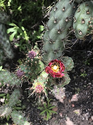
Look for coast cholla cactus along the trail
At the trailhead on the southern side of Euclid Avenue, a few tall eucalyptus trees provide shade. As you make your way down the trail, you will find a variety of native plants, including flat-top buckwheat (Eriogonum fasciculatum) and chaparral mallow (Malacothamnus fasciculatus) boasting pink to purple flowers when blooming. You will then pass by a large stand of yerba santa (Eriodictyon crassifolium), which has fuzzy whitish-green leaves and purple flowers when in bloom. Soon you will reach a restoration site with a rock-lined path. You can find coast live oak trees (Quercus agrifolia) and other native plants that have recently been planted in this area in an effort to bring back native habitats. Continuing on the trail, you will see a healthy patch of southern honeysuckle (Lonicera subspicata) vining through shrubs and then entering a covered area under a huge, tree-like laurel sumac (Malosma laurina). Farther down the trail, look to your right to see the hillsides of the canyon that the creek runs through, side canyons, and signs of cliff erosion over time. If you look closely, you can even spot some chalk dudleya (Dudleya pulverulenta) on the hillside. Continuing on, you will find mulefat plants (Baccharis salicifolia), an indicator of the riparian habitat along the creek. You will soon cross a white bridge and the trail will come to parallel Chollas Parkway. Farther on, you will see the orange strands of the parasitic plant dodder (Cuscuta californica) covering many plants. While dodder does live off its host plants, it does not kill them. Continue on the path as it veers right and turns away from the road and the fence. Go west on the path and you will see a trail on your right. Turn down the trail and it will take you back to the main path, which will take you back to the start. This path is lined with broom baccharis (Baccharis sarothroides), San Diego sunflower (Bahiopsis laciniate) and California sunflower (Encelia californica), making it very colorful when in bloom.
Once back to where you started on Euclid Avenue, if you’d like to continue on, cross the street and head west on Euclid Avenue, crossing over the creek and walking up the hill. On the right-hand side, there will be a trailhead that you will turn down. Depending on the time of year, this trail can be overgrown, but it is easy to follow and there is some great habitat to be found in this section. If you’d like a less wild experience, you can parallel the creek on the east side, following a combination of trail and street paths.
The northern section of the trail features many of the same plants as the southern section, but there are some new varieties as well. You will find a few spiny redberry bushes (Rhamnus crocea) and a mature hollyleaf cherry tree (Prunus ilicifolia) right along the trail. On the hillside to your left, you will see a huge growth of coast cholla cactus (Cylindropuntia prolifera) with a few Mojave yucca plants (Yucca schidigera) below. Fields of tarweed (Madia sativa) can be seen and wild cucumber (Marah macrocarpa) winds through many plants. You will turn around on this trail once it reaches Chollas Parkway North, just south of Salta Place.
Throughout the walk, you can find all sorts of wildlife as well. Many bird species can be seen enjoying their native habitat, including scrub jays, mourning doves and Anna’s hummingbirds. Ravens and hawks can be seen and heard soaring overhead. During the spring, bees and butterflies are abundant and during the summer, lizards can be seen sunning themselves on the trail.
This route can be lengthened by continuing on the trails in either direction. These trails can also be linked to the City Heights Canyons Loop Trail system by hopping on Euclid Avenue, going west for 3 blocks, then following Euclid as it turns north for a block. The trailhead into Olivia (47th Street) Canyon will be on the west side of the street. This system includes Manzanita Canyon, Hollywood Canyon, and Swan Canyon.
The best time of year to visit the trail is in the cooler months of spring when the native plants are in bloom. There is not much shade on the trail so it’s best to avoid hot days and it is important to wear sun protection and bring water.
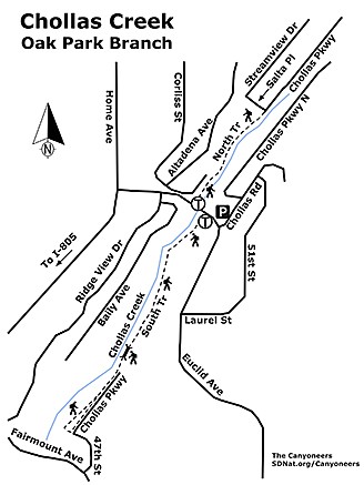
Chollas Creek map
CHOLLAS CREEK (OAK PARK BRANCH)
Enjoy a creekside walk in urban San Diego.
Driving directions: From I-805, take the Home Avenue exit, go northeast on Home Avenue, continue on Home Avenue, turn right on to Euclid Avenue, follow this 0.3 mile until you reach Chollas Road. Residential parking near this intersection. Hiking length: 2.5 miles out-and-back, options to continue farther on trails from both ends of the route, or to link into canyon trails in the City Heights Canyons Loop Trail system for a much longer hike. Allow 1-1.5 hours. Difficulty: Easy. There area few spots where the trail narrows, but mostly it is flat with minimal elevation gain. No facilities.
Here's something you might be interested in.
Chollas Creek: threading City Heights, Encanto, Oak Park and other communities
Enjoy a creekside walk in urban San Diego.
Chollas Creek: threading City Heights, Encanto, Oak Park and other communities
Enjoy a creekside walk in urban San Diego.
The blue cones in a restoration area are used to protect the newly-planted native plants along a rock-lined path
Chollas Creek runs through urban San Diego and is part of the Pueblo Watershed, running 32 miles from its headwaters in La Mesa and Lemon Grove to where it drains into San Diego Bay in Barrio Logan. The creek has four branches from its headwaters and runs through communities such as City Heights, Encanto, and Oak Park. The creek was a significant settlement for the Kumeyaay and provides multiple benefits to the region. Many nonprofits and organizations, including Groundwork San Diego-Chollas Creek and San Diego Canyonlands, have been working hard to restore and clean up the creek, improving trails and habitat.
This section of Chollas Creek runs through the community of Oak Park and is managed by the City of San Diego. There are trailheads at each end of this route, but the starting point for this hike is Euclid Avenue, taking the southern portion of the route, returning to the starting place, and then taking the northern portion of the route. Going south from Euclid Avenue is about a 1.75 mile out-and-back loop, and going north is about a 0.75 mile out-and-back loop.
Look for coast cholla cactus along the trail
At the trailhead on the southern side of Euclid Avenue, a few tall eucalyptus trees provide shade. As you make your way down the trail, you will find a variety of native plants, including flat-top buckwheat (Eriogonum fasciculatum) and chaparral mallow (Malacothamnus fasciculatus) boasting pink to purple flowers when blooming. You will then pass by a large stand of yerba santa (Eriodictyon crassifolium), which has fuzzy whitish-green leaves and purple flowers when in bloom. Soon you will reach a restoration site with a rock-lined path. You can find coast live oak trees (Quercus agrifolia) and other native plants that have recently been planted in this area in an effort to bring back native habitats. Continuing on the trail, you will see a healthy patch of southern honeysuckle (Lonicera subspicata) vining through shrubs and then entering a covered area under a huge, tree-like laurel sumac (Malosma laurina). Farther down the trail, look to your right to see the hillsides of the canyon that the creek runs through, side canyons, and signs of cliff erosion over time. If you look closely, you can even spot some chalk dudleya (Dudleya pulverulenta) on the hillside. Continuing on, you will find mulefat plants (Baccharis salicifolia), an indicator of the riparian habitat along the creek. You will soon cross a white bridge and the trail will come to parallel Chollas Parkway. Farther on, you will see the orange strands of the parasitic plant dodder (Cuscuta californica) covering many plants. While dodder does live off its host plants, it does not kill them. Continue on the path as it veers right and turns away from the road and the fence. Go west on the path and you will see a trail on your right. Turn down the trail and it will take you back to the main path, which will take you back to the start. This path is lined with broom baccharis (Baccharis sarothroides), San Diego sunflower (Bahiopsis laciniate) and California sunflower (Encelia californica), making it very colorful when in bloom.
Once back to where you started on Euclid Avenue, if you’d like to continue on, cross the street and head west on Euclid Avenue, crossing over the creek and walking up the hill. On the right-hand side, there will be a trailhead that you will turn down. Depending on the time of year, this trail can be overgrown, but it is easy to follow and there is some great habitat to be found in this section. If you’d like a less wild experience, you can parallel the creek on the east side, following a combination of trail and street paths.
The northern section of the trail features many of the same plants as the southern section, but there are some new varieties as well. You will find a few spiny redberry bushes (Rhamnus crocea) and a mature hollyleaf cherry tree (Prunus ilicifolia) right along the trail. On the hillside to your left, you will see a huge growth of coast cholla cactus (Cylindropuntia prolifera) with a few Mojave yucca plants (Yucca schidigera) below. Fields of tarweed (Madia sativa) can be seen and wild cucumber (Marah macrocarpa) winds through many plants. You will turn around on this trail once it reaches Chollas Parkway North, just south of Salta Place.
Throughout the walk, you can find all sorts of wildlife as well. Many bird species can be seen enjoying their native habitat, including scrub jays, mourning doves and Anna’s hummingbirds. Ravens and hawks can be seen and heard soaring overhead. During the spring, bees and butterflies are abundant and during the summer, lizards can be seen sunning themselves on the trail.
This route can be lengthened by continuing on the trails in either direction. These trails can also be linked to the City Heights Canyons Loop Trail system by hopping on Euclid Avenue, going west for 3 blocks, then following Euclid as it turns north for a block. The trailhead into Olivia (47th Street) Canyon will be on the west side of the street. This system includes Manzanita Canyon, Hollywood Canyon, and Swan Canyon.
The best time of year to visit the trail is in the cooler months of spring when the native plants are in bloom. There is not much shade on the trail so it’s best to avoid hot days and it is important to wear sun protection and bring water.
Chollas Creek map
CHOLLAS CREEK (OAK PARK BRANCH)
Enjoy a creekside walk in urban San Diego.
Driving directions: From I-805, take the Home Avenue exit, go northeast on Home Avenue, continue on Home Avenue, turn right on to Euclid Avenue, follow this 0.3 mile until you reach Chollas Road. Residential parking near this intersection. Hiking length: 2.5 miles out-and-back, options to continue farther on trails from both ends of the route, or to link into canyon trails in the City Heights Canyons Loop Trail system for a much longer hike. Allow 1-1.5 hours. Difficulty: Easy. There area few spots where the trail narrows, but mostly it is flat with minimal elevation gain. No facilities.
Comments