Here's something you might be interested in.
Ask a Hipster — Advice you didn't know you needed
Big Screen — Movie commentary
Blurt — Music's inside track
Booze News — San Diego spirits
Classical Music — Immortal beauty
Classifieds — Free and easy
Cover Stories — Front-page features
Drinks All Around — Bartenders' drink recipes
Excerpts — Literary and spiritual excerpts
Feast! — Food & drink reviews
Feature Stories — Local news & stories
Fishing Report — What’s getting hooked from ship and shore
From the Archives — Spotlight on the past
Golden Dreams — Talk of the town
The Gonzo Report — Making the musical scene, or at least reporting from it
Letters — Our inbox
Movies@Home — Local movie buffs share favorites
Movie Reviews — Our critics' picks and pans
Musician Interviews — Up close with local artists
Neighborhood News from Stringers — Hyperlocal news
News Ticker — News & politics
Obermeyer — San Diego politics illustrated
Outdoors — Weekly changes in flora and fauna
Overheard in San Diego — Eavesdropping illustrated
Poetry — The old and the new
Reader Travel — Travel section built by travelers
Reading — The hunt for intellectuals
Roam-O-Rama — SoCal's best hiking/biking trails
San Diego Beer — Inside San Diego suds
SD on the QT — Almost factual news
Sheep and Goats — Places of worship
Special Issues — The best of
Street Style — San Diego streets have style
Surf Diego — Real stories from those braving the waves
Theater — On stage in San Diego this week
Tin Fork — Silver spoon alternative
Under the Radar — Matt Potter's undercover work
Unforgettable — Long-ago San Diego
Unreal Estate — San Diego's priciest pads
Your Week — Daily event picks
A peak experience with spectacular desert views
Hiking Sombrero Peak from Indian Gorge, there is no official trail or even agreed-upon route to the top
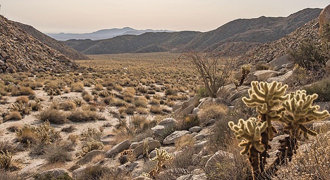
South Indian Valley view
Many reasons have been given for climbing Sombrero Peak, including its distinctive shape and the fact that it is quite prominent when viewed from Indian or Bow Willow Valleys. It is on the list of San Diego’s “Peak Baggers,” many of whom have “bagged” this iconic peak and left GPS tracks of the route they took, often reporting it is an easy climb with outstanding views off to the east. However, although it is only 4,229 feet in elevation, it is hard to find when approached from the west and not that easy of a climb.
Individuals whose primary interests are the beauty and natural history of the desert also will find much to enjoy, appreciate, and puzzle over in this ascent. The drive to the trailhead includes an unusual number of interesting things to see, such as the mini forest of smoke trees in Indian Gorge, elephant trees in Torote Canyon, and a thicket of desert willow at the entrance to the valley.
Keep in mind that there is no official trail or even agreed-upon route to the top. The ascent will require some route-finding experience, numerous places navigations around or over large boulders, encounters with cactus, catclaw, desert apricot, and other thorny shrubs, as well as steep climbs and descents.
The map included here shows three routes based on different GPS tracks. No matter which one you attempt, you will find stretches of marked use trail that can be followed, occasionally with ducks marking the way. The blue route is the fastest, taking you up a ridge straight to the top in a little over 1 mile, but it is a steep climb over and around boulders and cholla. The red route is about 1.25 miles long, one way, not quite as steep, and is marked with ducks most of the way. Our recommended route, shown here in green, is the longest at 1.46 miles, one way, but by far the most interesting.
All three routes start out hiking west up the canyon at the end of the road for about 0.2 mile. Here you will find a fairly well-defined use trail with many boot prints showing the way around the boulders to a ducked trail leading up the slope. This is where the three routes diverge.
To follow the green route, continue up the canyon through occasional thickets of desert apricot, cholla, catclaw, shiny-leaf yerba santa, and lemonadeberry as well as huge boulders for another 0.2 mile. At this point, the canyon appears to branch, with one branch going north. Avoid it and instead continue up the southwest branch. After navigating around dry falls, you will see numerous palms and dense thickets of mesquite and catclaw along the canyon floor. The use trail is mostly on the south side of the canyon above most of the largest boulders and thickest brush. Pause here to look for black-tailed gnatcatchers. These little birds, a close relative of the endangered coastal California gnatcatcher, are thriving here in the desert and are particularly at home in mesquite bosques.
At a little over 1 mile from the trailhead, start south up the boulder-covered slope leading to the peak, which is now visible. Soon you will find the trail to the peak from the west. The benchmark is on one of the large boulders that crown this peak. The view to the east is far and wide looking over Bow Willow Valley, while that to the west is a gradual descent to McCain Valley, which offers another approach to Sombrero Peak that is less steep but longer. For your descent, you may want to consider the red route, which will make a nice loop.
Sombrero Peak from Indian Gorge
Have a peak experience with spectacular desert views.
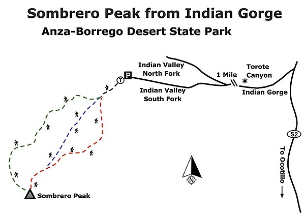
Sombrero Peak from Indian Gorge map
Driving Directions: (Ocotillo) Take I-8 E and exit onto County Route S-2 going north to milepost 46.1 (GPS N32.879541, W116.211285) and take the dirt road signed Indian Gorge on the west side of the highway. A 4WD vehicle is recommended for the 2-mile drive across the soft sandy, rocky road that passes through Indian Gorge and the bajada leading to it. Shortly after you come to the sign for Torote Canyon, on the right, the broad, flat Indian Valley opens up and the road improves. At 2.7 miles from the S-2, the road across Indian Valley splits into north and south forks. Take the south fork and continue another 3 miles to its end, the hike’s trailhead. Distance: 3+ miles, out-and-back. Allow 4 hours hiking time. Difficulty: Moderate. Elevation gain/loss, about 2,000 feet.
Here's something you might be interested in.
A peak experience with spectacular desert views
Hiking Sombrero Peak from Indian Gorge, there is no official trail or even agreed-upon route to the top
A peak experience with spectacular desert views
Hiking Sombrero Peak from Indian Gorge, there is no official trail or even agreed-upon route to the top
South Indian Valley view
Many reasons have been given for climbing Sombrero Peak, including its distinctive shape and the fact that it is quite prominent when viewed from Indian or Bow Willow Valleys. It is on the list of San Diego’s “Peak Baggers,” many of whom have “bagged” this iconic peak and left GPS tracks of the route they took, often reporting it is an easy climb with outstanding views off to the east. However, although it is only 4,229 feet in elevation, it is hard to find when approached from the west and not that easy of a climb.
Individuals whose primary interests are the beauty and natural history of the desert also will find much to enjoy, appreciate, and puzzle over in this ascent. The drive to the trailhead includes an unusual number of interesting things to see, such as the mini forest of smoke trees in Indian Gorge, elephant trees in Torote Canyon, and a thicket of desert willow at the entrance to the valley.
Keep in mind that there is no official trail or even agreed-upon route to the top. The ascent will require some route-finding experience, numerous places navigations around or over large boulders, encounters with cactus, catclaw, desert apricot, and other thorny shrubs, as well as steep climbs and descents.
The map included here shows three routes based on different GPS tracks. No matter which one you attempt, you will find stretches of marked use trail that can be followed, occasionally with ducks marking the way. The blue route is the fastest, taking you up a ridge straight to the top in a little over 1 mile, but it is a steep climb over and around boulders and cholla. The red route is about 1.25 miles long, one way, not quite as steep, and is marked with ducks most of the way. Our recommended route, shown here in green, is the longest at 1.46 miles, one way, but by far the most interesting.
All three routes start out hiking west up the canyon at the end of the road for about 0.2 mile. Here you will find a fairly well-defined use trail with many boot prints showing the way around the boulders to a ducked trail leading up the slope. This is where the three routes diverge.
To follow the green route, continue up the canyon through occasional thickets of desert apricot, cholla, catclaw, shiny-leaf yerba santa, and lemonadeberry as well as huge boulders for another 0.2 mile. At this point, the canyon appears to branch, with one branch going north. Avoid it and instead continue up the southwest branch. After navigating around dry falls, you will see numerous palms and dense thickets of mesquite and catclaw along the canyon floor. The use trail is mostly on the south side of the canyon above most of the largest boulders and thickest brush. Pause here to look for black-tailed gnatcatchers. These little birds, a close relative of the endangered coastal California gnatcatcher, are thriving here in the desert and are particularly at home in mesquite bosques.
At a little over 1 mile from the trailhead, start south up the boulder-covered slope leading to the peak, which is now visible. Soon you will find the trail to the peak from the west. The benchmark is on one of the large boulders that crown this peak. The view to the east is far and wide looking over Bow Willow Valley, while that to the west is a gradual descent to McCain Valley, which offers another approach to Sombrero Peak that is less steep but longer. For your descent, you may want to consider the red route, which will make a nice loop.
Sombrero Peak from Indian Gorge
Have a peak experience with spectacular desert views.
Sombrero Peak from Indian Gorge map
Driving Directions: (Ocotillo) Take I-8 E and exit onto County Route S-2 going north to milepost 46.1 (GPS N32.879541, W116.211285) and take the dirt road signed Indian Gorge on the west side of the highway. A 4WD vehicle is recommended for the 2-mile drive across the soft sandy, rocky road that passes through Indian Gorge and the bajada leading to it. Shortly after you come to the sign for Torote Canyon, on the right, the broad, flat Indian Valley opens up and the road improves. At 2.7 miles from the S-2, the road across Indian Valley splits into north and south forks. Take the south fork and continue another 3 miles to its end, the hike’s trailhead. Distance: 3+ miles, out-and-back. Allow 4 hours hiking time. Difficulty: Moderate. Elevation gain/loss, about 2,000 feet.
Comments